earth online
  • Explore Missions
    • Earth Explorers
    • Heritage Missions
    • Third Party Missions
  • Explore Data
    • All Data
    • Open Data
    • Announcement of Opportunity
    • Project Proposal
    • Sample Data
    • Dashboard
  • Explore Tools
    • Analysis Tools
    • Processing Tools
    • Visualisation Tools
    • Catalogues
    • Apps
  • Explore News & Events
    • All News
    • Data Release News
    • Maintenance News
    • Operational News
    • All Events
    • Events Updates
    • Workshop
    • Conference
  • Explore Learn & Discover
    • Data Application Articles
    • Spotlight on EO Community
    • Gallery
    • FAQ
    • Success Stories
    • Infographics
    • Quality Reports Advanced Search
  • SEE ALL
  • ALOS-1
  • ALOS-1
  • Mission
    • ALOS-1 Overview
    • ALOS-1 Objectives
  • Instruments
    • AVNIR-2
      • Explore AVNIR-2
      • AVNIR-2 Overview
      • AVNIR-2 Cal/Val
      • AVNIR-2 Products Information
      • AVNIR-2 Processor Releases
    • PALSAR
      • Explore PALSAR
      • PALSAR Overview
      • PALSAR Cal/Val
      • PALSAR Quality Control Reports
      • PALSAR Products Information
      • PALSAR Processor Releases
    • PRISM
      • Explore PRISM
      • PRISM Overview
      • PRISM Cal/Val
      • PRISM Products information
      • PRISM Processor Releases
  • ALOS-1
  • Mission
    • ALOS-1 Overview
    • ALOS-1 Objectives
  • Instruments
    • AVNIR-2
      • Explore AVNIR-2
      • AVNIR-2 Overview
      • AVNIR-2 Cal/Val
      • AVNIR-2 Products Information
      • AVNIR-2 Processor Releases
    • PALSAR
      • Explore PALSAR
      • PALSAR Overview
      • PALSAR Cal/Val
      • PALSAR Quality Control Reports
      • PALSAR Products Information
      • PALSAR Processor Releases
    • PRISM
      • Explore PRISM
      • PRISM Overview
      • PRISM Cal/Val
      • PRISM Products information
      • PRISM Processor Releases
More

    ALOS-1 INSTRUMENTS

    Explore instruments used in ALOS-1 mission.

    EXPLORE INSTRUMENTS

    ALOS-1 DATA

    Discover how to access ALOS-1 data.

    ACCESS MISSION DATA

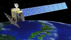
    The Advanced Land Observing Satellite (ALOS-1) was a Japanese Earth-imaging satellite from JAXA

    Featured

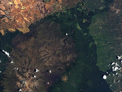
    Mafia Island, Tanzania As seen by ALOS-1

    Mafia Island, Tanzania As seen by ALOS-1

    This ALOS-1 satellite image from the AVNIR instrument, acquired on 7 September 2008, depicts the Mafia Archipelago, a cluster of islands in the Indian Ocean belonging to Tanzania.

    Urla, Türkiye: As seen by ALOS-1

    Urla, Türkiye: As seen by ALOS-1

    This ALOS-1 PRISM image, taken on 2 October 2011, shows part of the Urla Peninsula in Izmir Province, on the west coast of Türkiye.

    Gambia River, The Gambia: As seen by ALOS-1

    Gambia River, The Gambia: As seen by ALOS-1

    This ALOS-1 PRISM panchromatic image, acquired on 4 December 2006, shows a section of the Gambia River in West Africa

    Fiheranana and Manandana Rivers, Madagascar: As seen by ALOS-1

    Fiheranana and Manandana Rivers, Madagascar: As seen by ALOS-1

    This ALOS-1 PRISM panchromatic image, acquired on 24 December 2006, shows the Fiheranana and Manandona Rivers in southwestern Madagascar.

    Corsica, France: As seen by ALOS-1

    Corsica, France: As seen by ALOS-1

    This ALOS-1 PRISM panchromatic image, acquired on 4 May 2009, covers southern Corsica and its surrounding areas.

    About ALOS-1

    ALOS Satellite Image
    ALOS-1 mission

    The Advanced Land Observing Satellite (ALOS-1) was a Japanese Earth-imaging satellite from the Japan Aerospace Exploration Agency (JAXA) that launched on 24 January 2006 and completed its operational phase on 12 May 2011 after failing due to a power anomaly.

    ALOS-1 is part of ESA's Third Party Missions Programme, in which ESA has an agreement with JAXA to distribute data products from the mission.

    ALOS-1 Objectives

    The ALOS-1 mission objectives were:

    • Providing its user community with data of sufficient resolution to be able to generate 1:25,000 scale maps
    • Developing Digital Elevation Models and related geographic data products
    • Performing regional observation to aid sustainable development goals
    • Surveying natural resources
    • Develop sensor and satellite technology for future Earth-observation missions
    • Disaster monitoring around the world.

    ALOS-1 Instruments
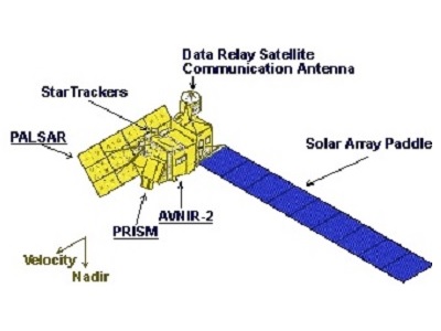
    PRISM instrument
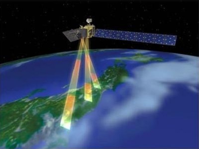
    The Panchromatic Remote-sensing Instrument for Stereo Mapping (PRISM) was a panchromatic radiometer with 2.5 m spatial resolution at nadir. Its extracted data was designed to provide highly accurate digital surface models (DSM).
    Find out more
    PALSAR instrument
    The Phased Array L-band Synthetic Aperture Radar (PALSAR) was a successor sensor to the SAR on-board JERS-1 with more advanced functions such as higher spatial resolution and ScanSAR mode.

    Find out more
    AVNIR-2
    The Advanced Visible and Near-Infrared Radiometer-2 (AVNIR-2) was a four band (visible and near-infrared) radiometer with a resolution of 10 m, designed for observing land and coastal zones.

    Find out more

    The ALOS-1 instruments were capable of observing the entire surface of the Earth:

    • Any place within two days
    • Around the equator: about 60% of the area within one day
    • At latitudes of 35°: about 70% of the area within one day
    • At latitudes above 55°: any place every day (provided there is no cloud cover for the optical instruments)

    Night-time observation modes: PALSAR (Note: AVNIR-2 and PALSAR are able to operate simultaneously).

    PALSAR calibration is provided with PARC (Polarimetric Active Radar Calibrator) as well as by other means.


    Non-scientific measuring instruments:

    • AOCS (Attitude Orbit and Control System)
    • RRA (RetroReflector Array)
    • SST (Star Tracker)

    ALOS-1 Data

    DATA COLLECTIONS

    Through the Online Dissemination server, ESA offers registered users access to the following data collections:

    • ALOS PALSAR Products
    • ALOS PALSAR International Polar Year Antarctica
    • ALOS PRISM L1B
    • ALOS PRISM L1C
    • ALOS PRISM L1C European Coverage Cloud Free
    • ALOS African Coverage ESA archive
    • TropForest - ALOS, Deimos-1 & KOMPSAT-2 optical coverages over tropical forests
    • ALOS AVNIR-2 L1C
    Tweet
    Share

    People also search for

    DataNewsMissionsEventsTools and toolboxesActivitiesCampaignsLearn & Discover
    European Space Agency
    Terms and conditionsCookie NoticePrivacy NoticeContact UsFAQComplaintsLeave feedback