- Data
- TropForest - ALOS, GEOSAT-1 & ...
TropForest - ALOS, GEOSAT-1 & KOMPSAT-2 optical coverages over tropical forests
Navigate To
How to Access Data
EO Sign In Authentication (Open)
- Go to the Dissemination Service
- Find the product you want via a map
- Register or log in to EO Sign In
- Download.
In ESA's Third Party Missions (TPM) dissemination service and catalogue the data is collection based and allows data browse and download through the treeview as well as via geographical search using a static map.
The data can also be discovered through ESA's EO Catalogue (EO CAT), which allows users to browse and download products among the available datasets from ESA and Third Party Missions and instruments, using various criteria (spatial, temporal).
New users can register an account on EO Sign In. For further information about the EO Sign In Service you can visit TellUs.
ESA internal users can use their ESAAD account.
Should you need support to access the data, please contact EOHelp.
Collection Description
The objective of the ESA TropForest project was to create a harmonised geo-database of ready-to-use satellite imagery to support 2010 global forest assessment performed by the Joint Research Centre (JRC) of the European Commission and by the Food and Agriculture Organization (FAO). Assessments for year 2010 were essential for building realistic deforestation benchmark rates at global to regional levels.
To reach this objective, the project aimed to create a harmonised ortho-rectified/pre-processed imagery geo-database based on satellite data acquisitions (ALOS AVNIR-2, GEOSAT-1 SLIM6, KOMPSAT-2 MSC) performed during year 2009 and 2010, for the Tropical Latin America (excluding Mexico) and for the Tropical South and Southeast Asia (excluding China), resulting in 1971 sites located at 1° x 1° geographical lat/long intersections. The project finally delivered 1866 sites (94.7% of target) due to cloud coverages too high for missing sites.
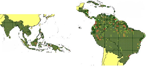
Spatial coverage: Check the spatial coverage of the collection on a map available on the Third Party Missions Dissemination Service.
Technical Details
DATA SET SPECIFICATIONS
- European Space Agency, 2016, ESA TropForest Archive. Version 1.0.https://doi.org/10.5270/esa-qoe849q
PROCESSING LEVEL
APPLICABLE TERMS & CONDITIONS
DATA CITATION
Having Problems Accessing Data?
Resources
Available products in TropForest dataset map
Available products in TropForest dataset (dark green, light green and blue circles)
Discover Latest Data
Announcement of Opportunity for Spire data
ESA is launching an Announcement of Opportunity for the international scientific community to access data from the Spire mission for science...
ERS ATSR L1B Brightness Temperature/Radiance [ER1_AT_1_RBT / ER2_AT_1_RBT]
Band measurements with associated uncertainty estimates. The ERS-1/2 ATSR Level 1B Brightness Temperature/Radiance products (RBT) contain to...
TomoSense
The TomoSense experiment was conceived to provide the scientific community with unprecedented data to study the features of radar scattering...
WIVERNex-UK
This campaign was designed to extend the Chilbolton ground measurement record that involved analysis of radar observations made by the 94 GH...