AVNIR-2 Overview

AVNIR-2 was a four band (visible and near-infrared) radiometer with a resolution of 10 m, designed for observing land and coastal zones. The images provide the basis for land coverage and land-use classification maps for monitoring regional environments. In addition, the instrument had a cross track pointing capability useful for quick response applications including disaster monitoring.
AVNIR-2 was programmed for repetitive, global-scale observations, and like PRISM and PALSAR, the observation strategy implemented aimed to maintain both spatial and temporal consistency over regional scales. The timing of the regional observations had been determined based on cloud statistics, seasonality and sun elevation, although cloud cover inevitably limited the amount of useful data acquired.
The default mode for AVNIR-2 was nadir view.
For any given region, AVNIR-2 was typically scheduled for "one acquisition during two consecutive cycles", meaning that if an acquisition was successfully programmed the first of the two cycles in question, it was not included in the plan during the second (regardless of cloud cover).
Instrument Design
Technical characteristics of AVNIR-2:
- Accuracy: 8 bits
- Spatial Resolution: 10 m (at NADIR)
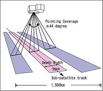
- Swath Width: 70 km (at NADIR)
- Waveband: 1: 0.42-0.50 microns 2: 0.52-0.60 microns, 3: 0.61-0.69 microns, 4: 0.76-0.89 microns
Sensor Modes
The only mode for AVNIR-2 is the observation mode which has the identification code OBS and is the nadir view mode: