ATSR Overview
Applications

The ATSR onboard the ERS missions had several applications spanning the disciplines of natural disasters, oceans & coast, snow & ice, atmosphere and land.
Forest Fires
A useful application of ATSR data was the detection of forest fires and other hotspots on Earth's surface.
Volcanoes
With such a huge number of potentially active volcanoes, traditional monitoring techniques such as seismic and microgravity require assistance if all these targets are to be kept under surveillance. Spaceborne remote monitoring is one method by which this may be achieved and the ATSR was well placed to assist in the development of such techniques. This was because it could view all of Earth's terrestrial volcanoes once every three days under nighttime conditions (the ideal time for such measurements to be made). ATSR measured the amount of thermal energy being emitted from Earth's surface, and these volcanic measurements could be related to the amount of high temperature activity occurring at centres of known active volcanoes.
Measure of Radiance
During night-time observations ATSR measured the amount of thermal radiation arriving at the instrument in four different wavebands (1.6, 3.7, 11 and 12 µm), making measurements on a 1 x 1 km grid over the entire Earth surface. Whilst ATSR's longer wavelength channels were good for looking at energy emitted from ambient temperature surfaces such as the ocean, ATSR's short wavelength channel (1.6 µm) could be used to observe the significant amounts of energy emitted from very hot surfaces such as those found at active volcanoes. Since surfaces at temperatures less than around 300 °C do not emit significantly at 1.6 µm, any nighttime signal at this wavelength was evidence of high temperature activity at the location of interest. By monitoring this volcanic signal over time these measurements could be used to deduce changes in the nature of the high temperature activity and these inferences used to assist monitoring of the eruptive and pre-eruptive phenomena.
Oceans and Coast
The Earth's climate is subject to natural variability. Climatic conditions have ranged from the extensive continental glaciation characteristic of the Pleistocene Epoch, to the warm, humid conditions prevalent in the Carboniferous Period. Possibly the most serious change is the increase in atmospheric carbon dioxide (CO2) caused by the burning of fossil fuels. Climate models are united in predicting that this will cause an increase in global temperature, although the scale of this warming remains uncertain. The situation is complicated by the possibility that a short-term cooling trend, such as that due to volcanic dust or industrial aerosols, may mask any underlying increase in global temperature. Detection of such a warming trend therefore requires accurate measurement of the climate system for at least several decades.
Sea-surface temperature
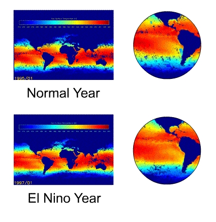
The temperature of the oceans is a particularly useful diagnostic of climate change because of its relative stability, and because it is among the more reliable parameters predicted by climate models. Detection of global patterns of change in sea-surface temperature requires global coverage, accuracy, and consistency of measurement.

El Niño is a quasi-periodic phenomenon involving various changes in oceanic and atmospheric conditions, notably a warming of water in the tropical Pacific. The time-scale for its reappearance varies from two to nine years. Typically starting around Christmas time and persisting for several months, an El Niño event is associated with significant changes in weather throughout the Southern Hemisphere. As an example of this, the massive 1982-3 El Niño caused severe drought in Australia, Indonesia, the Philippines, India, Central America and Southern Africa. Other effects included a significant increase in the frequency and severity of tropical cyclones, with a rare hurricane hitting Hawaii. In total, more than a thousand human lives were lost and damage in excess of five billion dollars was caused.
Although the origin of this natural phenomenon is not well understood, there are various indications of an approaching El Niño. Observations of developing ocean conditions have been used to successfully predict the onset and severity of several El Niños, such as the 1992 event.
Iceberg Studies
The ATSR instrument provided frequent observations of the Antarctic region, coverage of a large proportion of the coastline on a daily basis, and total coverage of the region every three days. Large icebergs, with a dimension of several kilometre's across or greater, are identified in the images and their dimensions determined. These data provided the basic information to allow an assessment to be made of their spatial distribution, of their calving, breakage and melt rates, and of their movement. The icebergs represented a major component of the mass discharge from the Antarctic ice sheet, and hence of the overall mass budget of the ice sheet. The other large, but poorly known, component of the mass discharge occurs through melting from the base of the floating ice.
Deforestation
Earth's forests play an important role in absorbing carbon dioxide from the planet's atmosphere, and their destruction contributes to the Greenhouse Effect. On a local scale, deforestation has had dramatic effects on the climate with the combination of reduced rainfall and soil erosion compromising attempts at agricultural use of the cleared land.
Clear evidence of the anthropogenic origin of this destruction is the regularity and linearity of the inroads that have been made into the forest. Many remarkably straight tracks are several hundreds of kilometre's long, and were clearly apparent from ATSR's vantage point 780 km in space. Ground-based estimates of the scale and rate of deforestation are notoriously inaccurate. However, satellite images provide a reliable and convenient method for long-term global monitoring of this phenomenon.
Design

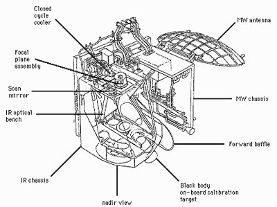
The ATSR instrument was designed for exceptional sensitivity and stability of calibration which was achieved through the incorporation of several innovative features in the instrument design:
- use of low-noise infrared detectors, cooled to near-optimum temperatures (i.e., less than 95K) by a Stirling cycle mechanical cooler
- continuous on-board radiometric calibration of the infrared channels against two stable, high-accuracy blackbody calibration targets
- use of the multichannel approach to SST retrieval previously demonstrated by the AVHRR instruments
- use of the "along-track scanning" technique to provide two views of the surface and thus an improved correction for atmospheric effects
Along-Track Scanning
Application of the along-track scanning technique was the ATSR instrument's most innovative development. This worked by making two observations of the same point on Earth's surface through differing amounts of atmosphere; the along-track view passed through a longer atmospheric path and so was more affected by the atmosphere than the nadir view.
First, the ATSR viewed the surface along the direction of the orbit track at an incidence angle of 55 degrees as it flew toward the scene. Then, some 150 seconds later, ATSR recorded a second observation of the scene at an angle close to the nadir. By combining the data from these two views a direct measurement of the effect of the atmosphere was obtained, and this yielded an atmospheric correction for the surface data set which was an improvement on that obtained from a single measurement.
ATSR-1 was the test-bed for the along-track scanning concept. It carried infrared channels at 1.6 µm, 3.7 µm, 10.8 µm and 12.0 µm, and had no visible channels. ATSR-2 continued the concept with added visible channels at 0.55 µm, 0.67 µm and 0.87 µm.
ATSR's field of view comprised two 500 km-wide curved swaths, with 555 pixels across the nadir swath and 371 pixels across the forward swath. The nominal instantaneous field of view (IFOV) pixel size was 1 km2 at the centre of the nadir swath and 1.6-µm processing.
- Accuracy: Sea surface temperature to < 0.5K over 0.5° x 0.5° (lat/long) area with 80% cloud cover, Land surface temperature: 0.1 K
- Spatial Resolution: IR ocean channels: 1 km x 1 km, Microwave near-nadir viewing: 20-km instantaneous field of view
- Waveband:
| ATSR-1 | |
| Wavelength (μm) | Bandwidth (μm) |
| 1.6 | 0.3 |
| 3.7 | 0.3 |
| 10.8 | 1.3 |
| 12.0 | 1.3 |
| ATSR-2 | |
| Wavelength (μm) | Bandwidth (μm) |
| 0.55 | 20 nm |
| 0.67 | 20 nm |
| 0.87 | 20 nm |
| 1.6 | 0.3μm |
| 3.7 | 0.3μm |
| 10.8 | 1.3μm |
| 12.0 | 1.3μm |
- The ATSR-2 was developed from the original experimental ATSR-1 instrument which, in addition to the ATSR-1's infrared channels, carry extra visible channels at 0.55μm, 0.67μm and 0.87μm for vegetation remote sensing. The evolution of ATSR-2 was constrained by the requirement to maintain the ATSR-1 precision measurement of global SST.
- Microwave: 23.8 GHz, 36.5 GHz (bandwidth of 400 MHz)
Mission Operations
The operations anomaly log for the ATSR instrument is available:
Note that any products generated during outgassings, blackbody crossover tests, and satellite manoeuvres should be used with caution; the fourth reprocessing L1B products have their quality designated as DEGRADED in the manifest file for these times. Other information regarding product quality is provided in the ATSR-1/-2 Product Notice readme file:
ATSR Resources
- ATSR Sensors website (ATSR Exploitation Board)
- ATSR Project website (Rutherford Appleton Laboratory)
- ATSR Reprocessing for Climate Dataset of Sea Surface Temperature Retrievals
- Group for High Resolution Sea Surface Temperature
- ESA Sea Surface Temperature project Climate Change Initiative (ESA SSI CCI)
- ESA Land Surface Temperature project Climate Change Initiative (ESA SSI CCI)
- ATSR Technical Documents
- ATSR User Guide
- ATSR L1B Product Specification
- User Documentation for (A)ATSR 4th Reprocessing Level 1B Products
- REAPER : ERS-1 and ERS-2 Orbit Validation Report