- All Categories (42692)
- Data (124)
- News (286)
- Missions (32)
- Events (81)
- Tools (27)
- Activities (22)
- Campaigns (40)
- Documents (42080)
DATA
Discover and download the Earth observation data you need from the broad catalogue of missions the European Space Agency operate and support.
Data - Campaigns (Open)

SEN2FLEX
SENtinel-2 and FLuorescence EXperiment (SEN2FLEX) campaign combines different activities in support of initiatives related both to fluorescence experiments and Sentinel-2 initiative for prototyping of resolutions to meet mission requirements.
Data - Campaigns (Open)

PolarGap
The primary objective of the PolarGap campaign was to carry out an airborne gravity survey covering the southern polar gap of the gravity field mission GOCE, beyond the coverage of the GOCE orbit.
Data - Campaigns (Open)
PhotoProxy 2019
The Photosynthetic-Proxy Experiment campaign address relevant open aspects that are related to the quantitative assessment of vegetation photosynthesis and vegetation stress from space.
Data - Campaigns (Open)
LOSAC
The L-band Ocean Salinity Airborne Campaign (LOSAC) objective is to understand the nature of the wind driven signatures in order to evaluate if corrections are necessary prior to salinity estimations based on the radiometer signals.
Data - Campaigns (Open)

LaRA
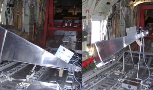
To improve our knowledge of how best to measure ice thickness, the airborne Laser and Radar Altimeter campaign (LaRA) was carried out over the frozen expanses of northern Greenland.
Data - Campaigns (Open)

BACCHUS-DOC
The BACCHUS-DOC Radar and Optical Campaign was an area mapping project of vineyards near Frascati (Italy). ESA required high resolution geo-referenced airborne SAR data of different wavelength and polarisation (preferably polarimetric).
Data - Campaigns (Open)

Sentinel-3 OLCI Tandem 2018
In 2018, a tandem campaign was conducted between the Sentinel-3A and 3B satellites to help test the future FLEX mission.
Data - Campaigns (Open)
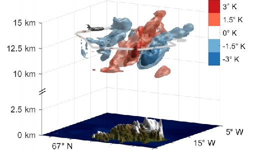
GWEX
The aim of this study was to perform Gravity Wave (GW) observations with the airborne IRLI GLORIA on board of HALO. In this way for a first time 3-D tomographic reconstructions of mesoscale GW events in the lower stratosphere were taken.
Data - Campaigns (Open)

WISE
The objective of WInd and Salinity Experiment 2001 (WISE 2001) was to get more data points and better wind speed (WS) measurements so as to reduce the sensitivity to WS uncertainty.
Data - Campaigns (Open)
WaddenSAR
The “WaddenSAR – Airborne bistatic C-band SAR experiment to demonstrate different acquisition geometries” was initiated to support the development of the Earth Explorer 10 Harmony mission.
Data - Campaigns (Open)

AfriScat
AfriScat campaign, a follow on to TropiSCAT campaign, was to acquire long-term P-Band radar data in an African tropical forest.
Data - Campaigns (Open)

AirScatterGNSS
In this project an Airborne Wind Vector Scatterometer (AWVS) system was designed and built for measurements of sea surface backscattering from an aircraft.
Data - Campaigns (Open)

AlpTomoExp
The AlpTomoSAR experiment has been conceived to support studies related to SAOCOMCS tomography for mapping the 3D internal structure of glaciers.
Data - Campaigns (Open)

CIMREx
CIMREx airborne campaign aimed to sample the sea ice microwave emissions from various sea ice regimes around Svalbard and Greenland.
Data - Fast Registration with approval (Restrained)
ERS-1/2 ATSR Averaged Surface Temperature [AT1/AT2_AR__2P]
The Averaged Surface Temperature Product (AST) contains averaged geophysical data at two different resolutions, and with respect to two different averaging schemes: measurement data sets at resolutions of 0.5 by 0.5 degrees and 10 by 10 arcmin with respect to a latitude/longitude grid; other data sets contain data averaged over equal area cells of 50 by 50 km and 17 by 17 km aligned with the satellite ground track. Both top-of-atmosphere and surface data sets are provided. The surface temperature data sets provide, for sea cells, nadir and dual view sea surface temperatures, and for land cells, land surface temperature (currently 11 micron BT) and NDVI. Cloud data is also included. No ADS are included in the AST product; auxiliary data is contained within the MDS. The data sets of the AST product are arranged by surface type and resolution. The 3rd reprocessing of ATSR data was performed in 2013; the processing updates that have been put in place and the scientific improvements are outlined in full in the User Summary Note for the Third ERS ATSR Reprocessing.
Data - External Data (Restrained)
ERS-1/2 ATSR ARC Level 3 products [AT1/AT2_AVG_3PAARC]
The recommended ATSR Level 3 products for Sea Surface Temperature (SST) applications are the ARC (ATSR Re-processing for Climate) Level 3 products. ARC reprocesses the ATSR multi-mission archive using new cloud detection and SST retrievals to produce a homogenous record of sea surface temperature. The main ARC objective is to reduce regional biases in retrieved SST to less than 0.1 K for all global oceans while creating a very homogenous record with a stability (lack of drift in the observing system and analysis) of 0.05 K per decade. ARC products are available for ATSR-1, ATSR-2 and AATSR. ARC products are provided in netCDF format and contain data for both the skin SST and the SST estimated for depths of 0.2 and 1.0 m (corresponding approximately to drifter and moored buoy depths). The AATSR estimated depth SSTs are adjusted to a local equatorial crossing time of 10:30 (approximately half an hour after observation), to provide continuity with ATSR-1 and ATSR-2 data. The ARC project was led by Chris Merchant (University of Reading, formerly of the University of Edinburgh) and funded by NERC and the UK Government.
Data - Fast Registration with approval (Restrained)
ERS-1/2 ATSR Gridded Brightness Temperature/Reflectance [AT1/AT2_TOA_1P]
The Gridded Brightness Temperature/Reflectance (GBTR) product contains top of atmosphere (TOA) brightness temperature (BT) values for the infra-red channels and reflectance values for the visible channels. Values for each channel and for the nadir and forward views occupy separate measurement data sets. Additional MDS contain cloud and land/sea flags and confidence flags for each image pixel. The 3rd reprocessing of ATSR data was performed in 2013; the processing updates that have been put in place and the scientific improvements are outlined in full in the User Summary Note for the Third ERS ATSR Reprocessing.
Data - Fast Registration with approval (Restrained)
ERS-1/2 ATSR Gridded Surface Temperature [AT1/AT2_NR__2P]
The Gridded Surface Temperature (GST) Product is the Level 2 full resolution geophysical product. The product contains gridded sea-surface temperature images using both nadir and dual view retrieval algorithms. The product includes pixel latitude/longitude positions, X/Y offset and the results of the cloud-clearing/land-flagging. It contains a single measurement data set the content of which is switchable, that is to say, the content of each pixel field will depend on the surface type. Specifically, the contents of the data fields will depend on the setting of the forward and nadir cloud flags and the land flag. The 3rd reprocessing of ATSR data was performed in 2013; the processing updates that have been put in place and the scientific improvements are outlined in full in the User Summary Note for the Third ERS ATSR Reprocessing.
Data - Data Description
ERS-1/2 ATSR Meteo Product [AT1/AT2_MET_2P]
The data is a fast delivery Meteo product designed for use by meteorological offices, and contains averaged BT and SST at 10 arc minute resolution. The single MDS comprises the fields of MDS#3 (SST record, 10 arc min cell) of the AST product, with the addition of Average Brightness Temperature (ABT) fields (BT/TOA sea record, 10 arc min cell) to make it more self-contained. The 3rd reprocessing of ATSR data was performed in 2013; the processing updates that have been put in place and the scientific improvements are outlined in full in the User Summary Note for the Third ERS ATSR Reprocessing.
Data - Fast Registration with approval (Restrained)
ALOS PALSAR International Polar Year Antarctica
International Polar Year (IPY), focusing on the north and south polar regions, aimed to investigate the impact of how changes to the ice sheets affect ocean and climate change to the habitats in these regions. IPY was a collaborative project involving over sixty countries for two years from March 2007 to March 2009. To meet the project goal, world space agencies observed these regions intensively using their own Earth observation satellites. One of these satellites, ALOS - with the PALSAR (Phased Array type L-band Synthetic Aperture Radar) sensor - observed these regions independently from day-night conditions or weather conditions. Carrying on this initiative, ESA is providing the ALOS PALSAR IPY Antarctica dataset, which consists of full resolution ALOS PALSAR ScanSAR WB1 products (100 m spatial resolution) over Antarctica from July 2008 (cycle 21) to December 2008 (Cycle 24) and from May 2009 (cycle 27) to March 2010 (cycle 31). Missing products between the two periods above is due to L0 data over Antarctica not being available in ADEN archives and not processed to L1. Spatial coverage: Check the spatial coverage of the collection on a map available on the Third Party Missions Dissemination Service.