- Campaigns
- AirScatterGNSS
AirScatterGNSS
Overview
What was the purpose of AirScatterGNSS?
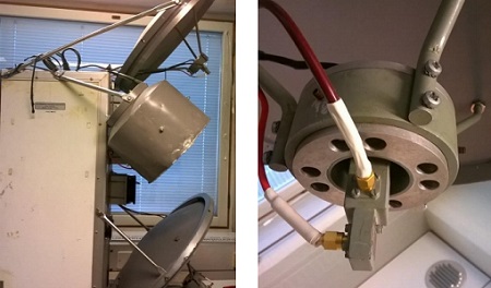
In this project an Airborne Wind Vector Scatterometer (AWVS) system was designed and built for measurements of sea surface backscattering from an aircraft. The instrument design was based on a mechanical framework and antennas already existing in the aircraft.
In the frame of this project the radar transmission/receiving electronics was designed, tested and build. Backend for the radar was compiled using a commercial data acquisition unit loaned for the project.
What was the outcome of AirScatterGNSS?
In the end, the developed AWVS scatterometer fulfilled the aims of this project.
In use, the developed scatterometer has shown great stability, which is probably due to careful component selection and good functionality of the thermal stabilisation system of HUTRAD. However, it was confronted during the project that the initalisation of the thermal control, which is done using 30 year old soft and hardware, has poor reliability.
Download the AirScatterGNSS final report
| Data Coverage (Year) | 2015 |
| Geographic Site | Gulf of Finland |
| Field of Application | Scatterometer wind data |
| Data Size | 35.3 Mb |
Digital Object Identifier: https://doi.org/10.5270/esa-1s4gfye - AirScatterGNSS: "Campaign based on Airborne Wind Vector Scatterometer to support validation of satellite GNSS-R measurements"
Data
The campaign data is available online via FTPS upon submission of a data access request. An active EO Sign In account is required to submit the request.
The data can be downloaded via an FTP client (e.g., FileZilla or WinSCP) using the option "Implicit FTP over TLS".
For further information about the EO Sign In Service you can visit TellUs
Should you need support please contact EOHelp