- All Categories (22)
- Data (9)
- News (5)
- Missions (6)
- Tools (2)
Data - Sample Data (Open)
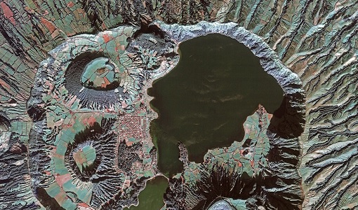
IRS-P5 (Cartosat-1) Sample Data
Download free IRS-P5 (Cartosat-1) sample datasets to preview products available for this mission.
Data - Sample Data (Open)
GEOSAT-2 Sample Data
Download free GEOSAT-2 sample datasets to preview products available for this mission.
News - Data Release news
GEOSAT-2 Spain Coverage 2022 collection open to users
ESA’s Earthnet Third Party Missions Programme presents the latest addition to its collection: the GEOSAT-2 Spain Coverage 2022.
News - General News
GEOSAT collaborates with ESA to boost understanding of the planet
Researchers around the world are exploring innovative scientific applications of high quality satellite data from commercial provider GEOSAT, thanks to a successful collaboration between the firm and ESA’s Third Party Missions (TPM) programme.
News - Data Release news
GEOSAT-2 Spain coverage new collection open for users
In the framework of ESA’s Earthnet Third Party Missions programme, we are glad to announce that there is a new collection open for users: the GEOSAT-2 Spain Coverage collection.
Data - Fast Registration with approval (Restrained)
GEOSAT-2 Spain Coverage
The GEOSAT-2 Spain Coverage collection consists of two separate coverages of Spain, including the Balearic and Canary islands, acquired by GEOSAT-2 between March and November of 2021 and 2022, respectively. The available imagery have a geolocation accuracy of < 4 m RMSE, a cloud cover percentage of < 10 %, and were acquired at an off-nadir angle from -30° to 30°. Spatial coverage of the 2021 collection. The following product types are available: Pan-sharpened: A four-band image, resulting from adding the information of each multispectral band to the panchromatic band. The fusion does not preserves all spectral features of the multispectral bands, so it should not be used for radiometric purposes. Resolution 1 m; Bands: All. Bundle: Panchromatic (1 m resolution) + Multispectral bands (4 m resolution): five-band image containing the panchromatic and multispectral products packaged together, with band co-registration. The available processing level is L1C orthorectified: a calibrated and radiometrically corrected product, manually orthorectified and resampled to a map grid. Property Spatial Resolution Pan-sharpened 1.0 m Bundle (PAN + MS) 1.0 m (PAN), 4.0 m (MS)
News - Data Release news
New data available: GEOSAT-2 Portugal Coverage 2021
A new collection is available to the public through ESA’s Earthnet Third Party Missions Programme: the GEOSAT-2 Portugal Coverage 2021.
Data - Project Proposal (Restrained)
GEOSAT-2 Portugal Coverage 2021
GEOSAT-2 Portugal coverage is a collection of 2021 data over the Portugal area, including islands. The available dataset has a cloud cover less than 10%, and is acquired up to 1m resolution with Geometric accuracy <6m CE90 based on Copernicus DEM @10m. GEOSAT-2 Portugal 2021 - Spatial Coverage of the Dataset The following product types are available: Pan-sharpened (4 bands, 321 Natural Colours or 432 False Colours): A four-band image, resulting from adding the information of each multispectral band to the panchromatic band. The fusion does not preserves all spectral features of the multispectral bands, so it should not be used for radiometric purposes. Resolution 1m; Bands: All, R-G-B or Ni-R-G Bundle: Panchromatic (1m resolution) + Multispectral bands (4m resolution): five-band image containing the panchromatic and multispectral products packaged together, with band co-registration. The available processing level is L1C orthorectified: a calibrated and radiometrically corrected product, manually orthorectified and resampled to a map grid. Product Type Processing Level and Spatial Resolution L1B (native) L1C (ortho) Pan-sharpened 1.0m 1.0m Bundle (PAN+MS) 1.0m (P), 4.0m (MS) 1.0m (P), 4.0m(MS)
Tools - Catalogues

FedEO
FedEO is a data catalogue that provides a unique entry point to a number of scientific catalogues and services for, but not limited to, European and Canadian missions.
Tools - Catalogues

EO CAT
EO CAT is a data catalogue, offering a Next Generation Earth Observation system designed to manage end-user Earth Observation services.
Data - Fast Registration with approval (Restrained)
GEOSAT-1 and 2 ESA archive
GEOSAT-1 and 2 dataset is composed of products acquired by the GEOSAT-1 and GEOSAT-2 Spanish satellites. The dataset regularly grows as ESA collects new products. GEOSAT-1 standard products offered are: SL6_22P: SLIM6, 22m spatial resolution, from bank P SL6_22S: SLIM6, 22m spatial resolution, from bank S SL6_22T: SLIM6, 22m spatial resolution, 2 banks merged together. GEOSAT-1 products are available in two different processing levels: Level 1R: All 3 Spectral channels combined into a band-registered image using L0R data. Geopositioned product based on rigorous sensor model. Coefficients derived from internal and external satellite orientation parameters coming from telemetry and appended to metadata. Level 1T: Data orthorectified to sub-pixel accuracy (10 metres RMS error approximately) with respect to Landsat ETM+ reference data and hole-filled seamless SRTM DEM data V3, 2006 (90 m). The use of the GCPs, it is not automatic, as it is done manually, which gives greater precision. (GCPs by human operators). GEOSAT-2 standard products offered are: Pan-sharpened (HRA_PSH four-band image, HRA_PS3 321 Natural Colours, HRA_PS4 432 False Colours): a four-band image, resulting from adding the information of each multispectral band to the panchromatic band. The fusion does not preserve all spectral features of the multispectral bands, so it should not be used for radiometric purposes. Panchromatic (HRA_PAN): a single-band image acquired by the panchromatic sensor. Multispectral (HRA_MS4): a four-band image acquired by the multispectral sensor, with band co-registration. Bundle (HRA_PM4): a five-band image contains the panchromatic and multispectral products packaged together, with band co-registration. Stereo Pair (HRA_STP): The image products obtained from two acquisitions of the same target performed from different viewpoints in the same pass by using the agility feature of the platform. It can be provided as a pair of pan sharpened or panchromatic images. GEOSAT-2 products are available in two different processing levels: Level 1B: A calibrated and radiometrically corrected product, but not resampled. The product includes the Rational Polynomial Coefficients (RPC), the metadata with gain and bias values for each band, needed to convert the digital numbers into radiances at pixel level, and information about geographic projection (EPGS), corners geolocation, etc. Level 1C: A calibrated and radiometrically corrected product, manually orthorectified and resampled to a map grid. The geometric information is contained in the GeoTIFF tags. Spatial coverage: Check the spatial coverage of the collection on a map available on the Third Party Missions Dissemination Service. As per ESA policy, very high-resolution imagery of conflict areas cannot be provided.
News - Infographics

An overview of the GEOSAT-2 high-resolution mission
The GEOSAT series consists of two very high-resolution satellites, capable of acquiring sub-metric multispectral images. The missions are part of ESA's Third Party Missions programme, and GEOSAT-2 is summarised in our latest infographic.
Data - Project Proposal (Restrained)
GEOSAT-2 full archive and tasking
GEOSAT-2 full archive and new tasking products are available in different bands combinations: Pan-sharpened (4 bands, 321 Natural Colours or 432 False Colours): A four-band image, resulting from adding the information of each multispectral band to the panchromatic band. The fusion does not preserves all spectral features of the multispectral bands, so it should not be used for radiometric purposes. Resolution 1m (L1B), 0.75m (L1C) or 0.40m (L1D); Bands: All, R-G-B or Ni-R-G Panchromatic: Single-band image coming from the panchromatic sensor. Resolution 1m (L1B) or 0.75m (L1C) Multispectral: Four-band image coming for the multispectral sensor, with band co-registration. Resolution 4m (L1B) or 3m (L1C) Bundle: Panchromatic + Multispectral bands: five-band image containing the panchromatic and multispectral products packaged together, with band co-registration. Resolution 1m+4m (L1B), 0.75m+3m (L1C) or 0.40m+1.6m (L1D); And in addition: Stereo Pair: Obtained from two acquisitions of the same target performed from different viewpoints in the same pass by using the agility feature of the platform. It can be provided as a pair of pan-sharpened or panchromatic images. The image products are delivered in GeoTIFF image format by default. JPEG-2000 format is also available on demand. Available processing levels are ortho-ready L1B (not resampled) and ortho L1C (orthorectified and resampled ). In addition, for Pan-sharpened and Bundle, also L1D (enhanced ortho) super-resolution products are available: based on artificial intelligence, this technology increases the original resolution and detail of an image without losing quality with respect to the original product. Product Type Processing Level and Spatial Resolution Spectral Bands L1B (orthoready) L1C (ortho) L1D (Enhanced Ortho) Pan-sharpened 1.0 m 0.75 m 0.4 m All R, G, B NI, R, G Pan 1.0 m 0.75 m Only Pan band MS 4.0 m 3.00 m Only MS band Bundle (PAN+MS) 1.0 m (P), 4.0 m (MS) 0.75 m (P), 3.0 m (MS) 0.4 m (P), 1.6 m (MS) All As per ESA policy, very high-resolution imagery of conflict areas cannot be provided.
Data - EO Sign In Authentication (Open)
IRS-1C/1D European coverage
IRS-1C/1D dataset is composed of products generated by the Indian Remote Sensing (IRS) Satellites 1C/1D PAN sensor. The products, acquired from 1996 to 2004 over Europe, are radiometrically and ortho corrected level 1 black and white images at 5 metre resolution and cover an area of up to 70 x 70 km. Sensor Type Resolution (m) Coverage (km x km) System or radiometrically corrected Ortho corrected (DN) Acquisition in Neustrelitz PAN Panchromatic 5 70 x 70 X X 1996 - 2004 IRS-1C/1D PAN data coverage of Europe acquired between 1996 to 1998. Copyright: 2015 GAF AG IRS-1C/1D PAN data coverage of Europe acquired between 1999 to 2001. Copyright: 2015 GAF AG IRS-1C/1D PAN data coverage of Europe acquired between 2002 to 2004. Copyright: 2015 GAF AG Spatial coverage: Check the spatial coverage of the collection on a map available on the Third Party Missions Dissemination Service.
Data - Project Proposal (Restrained)
IRS-1C/1D Full archive
The following products are available: PAN: Panchromatic, resolution 5 m, Coverage 70 km x 70 km, radiometrically and ortho (DN) corrected, LISS-III: Multi-spectral, resolution 25 m, Coverage 140 km x 140 km, radiometrically and ortho (DN) corrected (ortho delivered without Band 5) WiFS: Multi-spectral, resolution 180 m, Coverage 800 km x 800 km, radiometrically and ortho (DN) corrected. Sensor Type Resolution (m) Coverage (km x km) System or radiometrically corrected Ortho corrected (DN) Global archive PAN Panchromatic 5 70 x 70 X X 1996 – 2007 (IRS-1C) 1998 – 2009 (IRS-1D) LISS-III Multi-spectral 25 140 x 140 X X (without band 5) WiFS Multi-spectral 180 800 km x 800 km X X Note: Whether system corrected or radiometrically corrected products are available depends on sensor and processing centre For PAN and LISS-III ortho corrected: If unavailable, user has to supply ground control information and DEM in suitable quality For WiFS ortho corrected: service based on in house available ground control information and DEM.
Data - Project Proposal (Restrained)
CartoSat-1 archive and Euro-Maps 3D Digital Surface Model
CartoSat-1 (also known as IRS-P5) archive products are available as PAN-Aft (backward), PAN-Fore (forward) and Stereo (PAN-Aft and PAN-Fore). Sensor Products Type Resolution (m) Coverage (km x km) System or radiometrically corrected Ortho corrected (DN) Neustralitz archive Global archive PAN PAN-Aft (backward) PAN-Fore (forward) Stereo (PAN-Aft+PAN-Fore) Panchromatic 2.5 27 x 27 X X 2007 - 2016 2005 - 2019 Note: Resolution 2.5 m. - Coverage 27 km x 27 km System or radiometrically corrected. For Ortho corrected products, if unavailable, user has to supply ground control information and DEM in suitable quality For Stereo ortho corrected: only one of the datasets will be ortho corrected. Euro-Maps 3D is a homogeneous, 5 m spaced digital surface model (DSM) semi-automatically derived from 2.5 m in-flight stereo data provided by IRS-P5 CartoSat-1 and developed in cooperation with the German Aerospace Center, DLR. The very detailed and accurate representation of the surface is achieved by using a sophisticated and well adapted algorithm implemented on the basis of the Semi-Global Matching approach. In addition, the final product includes detailed flanking information consisting of several pixel-based quality and traceability layers also including an ortho layer. Product Overview Post spacing 5 m Spatial reference system DD, UTM or other projections on WGS84 Height reference system EGM96 Absolute vertical accuracy LE90 5-10 m Absolute Horizontal Accuracy CE90 5-10 m Relative vertical accuracy LE90 2.5 m File format GeoTIFF, 16 bit Tiling 0.5° x 0.5° Ortho Layer Pixel Size 2.5 m The CartoSat-1 products and Euro-Maps 3D are available as part of the GAF Imagery products from the Indian missions: IRS-1C, IRS-1D, CartoSat-1 (IRS-P5), ResourceSat-1 (IRS-P6) and ResourceSat-2 (IRS-R2) missions. Euro-Maps 3D available data map
Mission - Heritage Missions

IRS-1C and IRS-1D
The Indian Remote Sensing satellites IRS-1C and IRS-1D were identical Earth-imaging satellites operated by the Indian Space Research Organisation.
Mission - Heritage Missions
GEOSAT
The GEOSAT series consists of GEOSAT-1 and GEOSAT-2 missions. They are Earth imaging satellites. GEOSAT-2, a high resolution satellite, became the first European fully-private satellite capable of providing sub-metric multi-spectral imagery.
Mission - Third Party Missions

IRS-P5 (Cartosat-1)
IRS-P5 (Cartosat-1) was a stereoscopic Earth observation satellite that generated Digital Elevation Models (DEMs) and other value-added products.
Mission - Heritage Missions

IRS-1D
IRS-1D was part of the IRS (Indian Remote Sensing) satellites, a large family of Earth observation satellites operated by ISRO.