- Data
- CartoSat-1 archive and Euro-Ma...
CartoSat-1 archive and Euro-Maps 3D Digital Surface Model
Navigate To
How to Access Data
Project Proposal (Restrained)
- Go to the ESA User Services Portal
- Register or log in to EO Sign In
- After logging in, complete and submit the form with your proposed use of the data
- The proposal will be evaluated by ESA, which normally takes between 4 and 6 weeks
- Upon successful evaluation, you will receive a confirmation email, which describes the amount of data to be provided, and details of how to order the data.
The collection is open for research and application development projects only to users located in the territory of ESA Member States (including Canada), in the European Commission Member States.
Data are available to order on demand upon submission of a Project Proposal subject to evaluation and acceptance by ESA.
ESA will support as many high-quality and innovative projects as possible within the quota limit available, therefore only a limited amount of products can be allowed to each project.
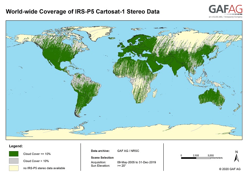
'Cartosat-1 archive' collection has worldwide coverage: for data acquired over Neustrelitz footprint, the users can browse the EOWEB GeoPortal catalogue to search archived products; worldwide data (out the Neustrelitz footprint) as well as Euro-Maps 3D DSM products can be requested by contacting GAF user support to check the readiness since no catalogue is not available.
All details about data provision and availability, data access conditions, usage restrictions and the quota assignment procedure are described in the Terms of Applicability document available in the Resources section.
If you need help with the proposal form, consult this guide on how to access data requiring a project proposal.
For further information about the EO Sign In Service you can visit TellUs.
Should you need support to prepare your proposal or access the data, please contact EOHelp.
Available to Residents of the Following Countries
Collection Description
CartoSat-1 (also known as IRS-P5) archive products are available as PAN-Aft (backward), PAN-Fore (forward) and Stereo (PAN-Aft and PAN-Fore).
| Sensor | Products | Type | Resolution (m) | Coverage (km x km) | System or radiometrically corrected | Ortho corrected (DN) | Neustralitz archive | Global archive |
| PAN | PAN-Aft (backward) PAN-Fore (forward) Stereo (PAN-Aft+PAN-Fore) | Panchromatic | 2.5 | 27 x 27 | X | X | 2007 - 2016 | 2005 - 2019 |
Note:
- Resolution 2.5 m. - Coverage 27 km x 27 km
- System or radiometrically corrected. For Ortho corrected products, if unavailable, user has to supply ground control information and DEM in suitable quality
- For Stereo ortho corrected: only one of the datasets will be ortho corrected.
Euro-Maps 3D is a homogeneous, 5 m spaced digital surface model (DSM) semi-automatically derived from 2.5 m in-flight stereo data provided by IRS-P5 CartoSat-1 and developed in cooperation with the German Aerospace Center, DLR.
The very detailed and accurate representation of the surface is achieved by using a sophisticated and well adapted algorithm implemented on the basis of the Semi-Global Matching approach. In addition, the final product includes detailed flanking information consisting of several pixel-based quality and traceability layers also including an ortho layer.
Product Overview
| Post spacing | 5 m |
| Spatial reference system | DD, UTM or other projections on WGS84 |
| Height reference system | EGM96 |
| Absolute vertical accuracy | LE90 5-10 m |
| Absolute Horizontal Accuracy | CE90 5-10 m |
| Relative vertical accuracy | LE90 2.5 m |
| File format | GeoTIFF, 16 bit |
| Tiling | 0.5° x 0.5° |
| Ortho Layer Pixel Size | 2.5 m |
The CartoSat-1 products and Euro-Maps 3D are available as part of the GAF Imagery products from the Indian missions: IRS-1C, IRS-1D, CartoSat-1 (IRS-P5), ResourceSat-1 (IRS-P6) and ResourceSat-2 (IRS-R2) missions.
Technical Details
DATA SET SPECIFICATIONS
PROCESSING LEVEL
APPLICABLE TERMS & CONDITIONS
Having Problems Accessing Data?
Resources
Discover Latest Data
Announcement of Opportunity for Spire data
ESA is launching an Announcement of Opportunity for the international scientific community to access data from the Spire mission for science...
ERS ATSR L1B Brightness Temperature/Radiance [ER1_AT_1_RBT / ER2_AT_1_RBT]
Band measurements with associated uncertainty estimates. The ERS-1/2 ATSR Level 1B Brightness Temperature/Radiance products (RBT) contain to...
TomoSense
The TomoSense experiment was conceived to provide the scientific community with unprecedented data to study the features of radar scattering...
WIVERNex-UK
This campaign was designed to extend the Chilbolton ground measurement record that involved analysis of radar observations made by the 94 GH...