- News & Events
- GEOSAT collaborates with ESA t...
GEOSAT collaborates with ESA to boost understanding of the planet
11 Jan 2024
Researchers around the world are exploring innovative scientific applications of high quality satellite data from commercial provider GEOSAT, thanks to a successful collaboration between the firm and ESA’s Third Party Missions (TPM) programme.
Several GEOSAT datasets – including recently released collections covering Spain and Portugal – are currently being disseminated via the TPM programme and more GEOSAT data are expected to be made available in the coming months.
Enabling climate-related applications
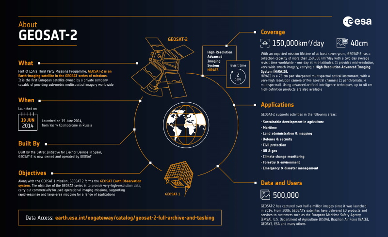
The recently published collections – based on optical data from the GEOSAT-2 mission – use artificial intelligence (AI) to deliver resolutions of up to 40 cm, revealing human-made infrastructure and the environment in exquisite detail.
These data are expected to enable research into climate trends, sustainable development in rural and urban areas, disaster monitoring and mitigation, and much more.
Several ongoing projects have already demonstrated the value GEOSAT data offer for these applications. Since 2021, for instance, Spanish institutions have been using GEOSAT-2 data to monitor coastal areas and inland waterbodies, as well as persistent snow and flooding, serving as a crucial asset for scientific applications that reveal long- and short-term environmental changes impacting Spanish territories.
In addition, GEOSAT-2 imagery offers a unique perspective on urban and rural settlements, as well as key natural resources. AI has been employed to transform these data into maps of fixed carbon to support agricultural productivity, and to develop models of urban areas in mountainous regions.
High data quality in the New Space era
Through its participation in the TPM programme, GEOSAT is contributing to ESA’s ambition to maintain excellent data standards as the number of New Space Earth observation missions continues to expand.
As with all TPM datasets, the recently released GEOSAT-2 collections over Spain and Portugal meet the most stringent requirements in terms of radiometric and geolocation accuracy, ensuring that data of the best possible quality is provided to scientists and application developers.
GEOSAT is also participating in an ESA-led initiative to establish a common framework for quality assessment by promoting and facilitating discussions between European space institutions and commercial New Space companies.
Within this activity, the company aims to draw on its Earth observation expertise to enable the development of further high-standard products designed to support a broad range of applications.
How to access the data
GEOSAT-2 collections over Portugal and Spain are disseminated via ESA’s TPM programme on a free basis for research and pre-operational application development purposes.
Users can request access using ESA’s Fast Registration with Approval process, which can take up to two days to be evaluated.
Two other GEOSAT collections are currently available under the TPM programme:
- GEOSAT-2 Full Archive and Tasking (available after the submission of a Project Proposal, which can take 4-6 weeks to be evaluated)
- GEOSAT-1 and 2 ESA Archive (available via Fast Registration with Approval)
Discover more TPM collections and how to navigate ESA’s data access processes online.