- CryoSat
- Data
- Data Description
CryoSat Data
Data Overview
CryoSat data is freely and openly available to everyone. CryoSat Level 0 data is acquired according to a geographic mode mask. This data is operationally processed using a number of processing chains to generate a suite of higher-level data products.
Go to the CryoSat products page to learn more about the products and how to access the data.
CryoSat Ice Products
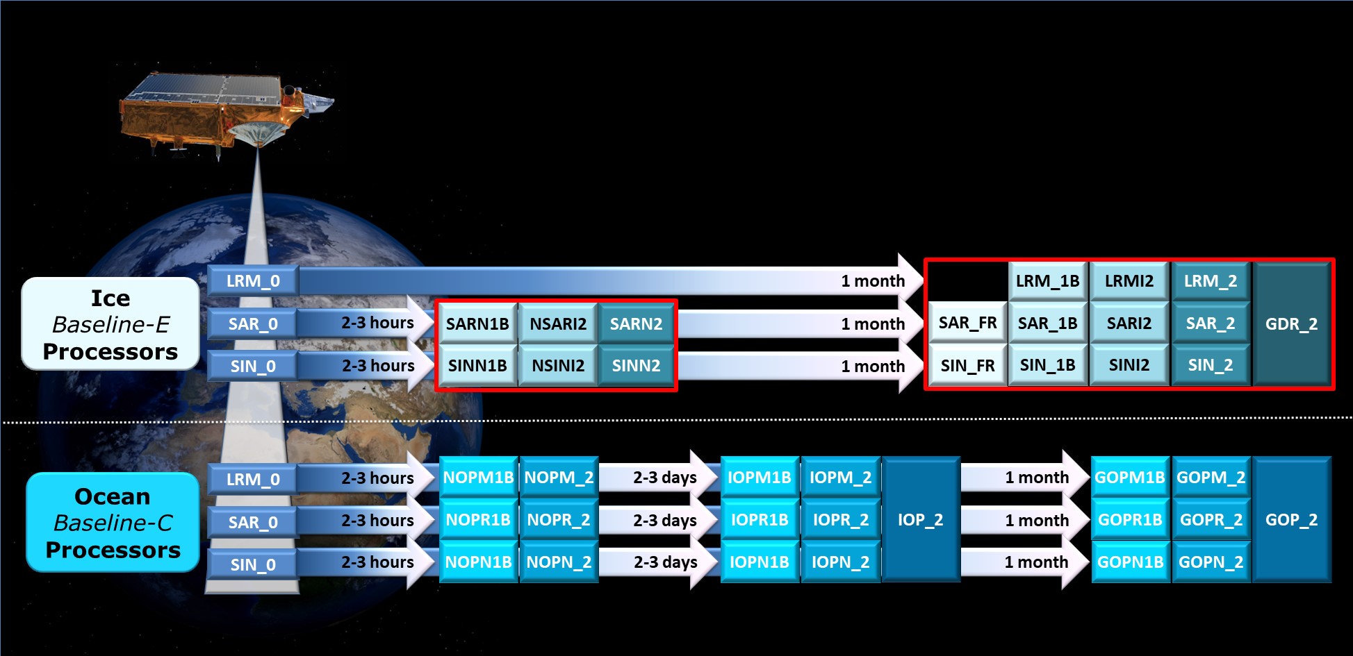
The CryoSat Ice Processor generates Ice products from L0 LRM, SAR and SARIn products. These products are primarily designed for the study of land ice and sea ice, although they are also relevant and useful to a wide range of additional applications. Products are generated at both Near-Real Time (NRT) and Offline latency.
NRT products are generated 2-3 hours after data sensing acquisition, using the DORIS Navigator Orbit with geophysical corrections computed from the Forecast meteorological Auxiliary Data Files (ADFs) where available. Previously NRT SAR and SARIn production was delayed awaiting the Refined Star Tracker File (ATTREF). At Baseline-D, in order to meet the expected near real time latency (2-3 hours after acquisition), the NRT chain was separated from the Offline Baseline-D IPFs. This allows processing to use the L0 Star Tracker products instead of the Star Tracker ATTREF products without delay.
Following the implementation of Near Real Time Ocean Products (NOP), FDM production was discontinued in February 2021, however NRT SAR and SARIn products will continue to be generated operationally.
Offline products are generated typically 30 days after data sensing acquisition using consolidated DORIS precise orbits (CNES Precise Orbit Ephemeris) and processed with geophysical corrections computed from the Analysis meteorological ADFs.
Level 1B Products
Level 1B (L1B) data consist, essentially, of an echo for each point along the ground track of the satellite. In all three modes, the data consist of multi-looked echoes at a rate of approximately 20 Hz.
In LRM, the contents of the L1B data are the same as that of the Full Bit Rate (FBR) data. These data are similar to the "WAP" data of the ERS-1 and ERS-2 altimeters. In SARIn mode, the multi-looked echo is complex, consisting of the echo power and interferometer phase. As with the FBR data, the data will have instrument and geophysical corrections appended and, in addition, the precise orbit. An important source of geophysical information is the variation in echo power as a function of the incidence angle of each Doppler beam. This information may also help determine Doppler beam ambiguity. This information is parameterised prior to multi-looking and included as part of the L1B data. In addition, in SARIn mode, the coherence of the interferometer phase is also estimated as part of the phase multi-looking and added to the L1B waveform.
Level 2 Products
Level 2 (L2) products are again generated at both Near-Real Time (NRT) and Offline. L2 data consists of individual estimates of the surface elevation and other surface parameters, such as the radar backscattering coefficient, determined from each echo in the Level 1B data. In LRM, these data are similar to the "OPR" data of the ERS altimeters. For elevations over ice sheets, the correction will be obtained from a Digital Elevation Model (DEM). In SAR mode, over sea-ice covered water, data will also include an estimate of ice thickness and other information derived from the echo power and its behaviour as a function of delay time and incidence angle. Over land ice, the data will be "slope-corrected". Where the data are derived from SARIn mode echoes, the correction will be determined from the interferometer phase.
L2 products are considered to be most suitable for users, as they contain surface height measurements fully corrected for instrumental effects, propagation delays, measurement geometry and additional geophysical effects such as atmospheric and tidal effects. In the Offline L2 products, the value of each geophysical correction provided is the value applied to the corrected Surface Height.
Level 2 In-depth Products
In-depth L2 (L2I) products are also available to users and can be identified with the 'I' in the file type (LRMI2, SARI2, SINI2). These products provide access to many low level parameters originating from the L1B, which are not available in the L2 product. The in-depth format is required as the input to the second pass of the L2 SAR processing chain for Sea Ice areas, and it is also useful for detailed analysis.
The L2I Measurement Dataset has a single format which is independent of mode. However the meaning of some fields is mode dependent, whilst other fields are entirely unused in some modes. The L2I format has been designed with the goal of ease of use rather than reduction of data volume. This means that there is repetition of some information that varies slowly. Geophysical corrections are interpolated at 1Hz and will therefore nominally be the same for 20 consecutive records. The corrections are interpolated at the latitude/longitude position given in the first of those 20 records.
Level 2 Global Data Record (GDR) Products
L2 GDR products are the outcome of the second step of L2 processing and are generated from the L2 mode dependent products collected over an entire orbit, specifically from ANX to ANX. This second step does not imply any specific processing, but simply a concatenation of input L2 files in chronological order.
Level 1 Full Bit Rate (FBR) Products
The main purpose of this Full Bit Rate (FBR) dataset is to allow independent investigation of the synthetic aperture processor (beam-formation and direction, slant range correction and multi-looking). FBR data is only provided for SAR and SARIn modes. FBR products contain the raw echoes as they are acquired by the instrument and need to be corrected for instrument calibration corrections by on-ground processing. Data is raw time-ordered provided prior to the application of the synthetic aperture, interferometric or accumulation processing.
Links
For more information on the format specification of Ice Baseline-E products, please consult:
General information about the Baseline-E Ice Processor is available in the following documents:
- L1B Product Specification and L2 Product Specification
- CryoSat Baseline E Ice Product Handbook
- CryoSat Baseline-E Evolutions
- CryoSat FBR Technical Note
For users still working with Baseline-D products, information about the Baseline-D Ice Processor is available in the following documents:
- L1B Product Specification and L2 Product Specification
- CryoSat Baseline D Ice Product Handbook
- CryoSat Baseline-D Evolutions
- CryoSat L2 Design Summary Document
For users still working with the Baseline-C Earth Explorer Format products (i.e. .DBL), please see the previous L1B Product Specification and L2 Product Specification.
CryoSat Ocean Products
The CryoSat Ocean Processor (COP) generates Ocean products from L0 LRM, SAR and SARIn products. These products are dedicated to the study of ocean surfaces, and provided specifically for the needs of the oceanographic community.
The COP provides three classes of products, which vary according to their delivery latency. These products are further classified according to the acquisition mode (LRM, SAR and SARIn). The processing applied to generate these products is the same in all cases and the only difference lies in the use of different input auxiliary files. This refers to the use of different orbit files, and different corrections included and applied.
- Near-Real Time Ocean Products (NOP) – LRM, SAR and SARIn mode products generated in near-real time, 2-3 hours after data acquisition. They are generated using the DORIS Navigator Orbit with geophysical corrections computed from the Forecast meteorological Auxiliary Data Files (ADFs) where available. This NRT processing is a new feature of the Baseline-C processors, and replaced FDM products in February 2021.
- Intermediate Ocean Products (IOP) – LRM, SAR and SARIn mode products generated 2-3 days after data acquisition for medium-range ocean forecasting. They are generated using the DORIS preliminary orbits (CNES Medium Orbit Ephemeris) with geophysical corrections computed from Analysis metrological ADFs, and when these are not available in time, the Forecast metrological ADFs.
- Geophysical Ocean Products (GOP) - LRM, SAR and SARIn mode products generated 30 days after data acquisition using consolidated DORIS precise orbits (CNES Precise Orbit Ephemeris) and processed with geophysical corrections computed from the Analysis meteorological ADFs.
Level 1B Products
The CryoSat Ocean products are designed to contain LRM/ Pseudo-LRM and SAR/ SARIn altimeter data together in the same product file. The formats of the L1B products are the same whatever the operating mode, and therefore the SAR/ SARIn-derived parameters are redundant in LRM/ Pseudo-LRM. L1B NOP, IOP and GOP contain all the engineering parameters needed to generate the Level 2 products, together with corrections to be applied for range and tidal effects.
Level 2 Products
The L2 NOP, IOP and GOP contain all the information necessary for the correct usage of the altimeter parameters over ocean surfaces, and therefore are considered to be more suitable for users. Geophysical corrections are provided in the L2 NOP, IOP and GOP however following the oceanographic convention the corrections are not applied to the range. The corrections are provided in the products to allow the user to apply them as required.
L2 NOP include geophysical corrections computed from the Forecast meteorological Auxiliary Data Files (ADFs) where available. L2 IOP include geophysical corrections computed from Analysis metrological ADFs, and when these are not available in time, the Forecast metrological ADFs. L2 GOP should always include geophysical corrections computed from the Analysis meteorological ADFs.
Pole-to-Pole Products
Global Pole-to-Pole (P2P) products are concatenated multi-mode L2 products generated for IOP and GOP. The products have half-orbit coverage, and therefore two P2P products are generated per orbit, spanning between the North and South poles and combining successive L2 IOP and GOP products respectively. These P2P products are delivered with the same latency as the input IOP and GOP products, i.e. 2-3 days and 30 days respectively.
It should be noted that the Baseline-C P2P products have been given the same product name as the Baseline-B L2 IOP and GOP but do not have the same content, frequency or size. NOP P2P products do not exist due to the 3-hour latency constraint.
Links
For more information on the format specification of the NetCDF Ocean Products, please consult the Ocean Product Format Specification.
General information about the Baseline-C Ocean Processors is available in the following documents and article:
Cryo-TEMPO Products
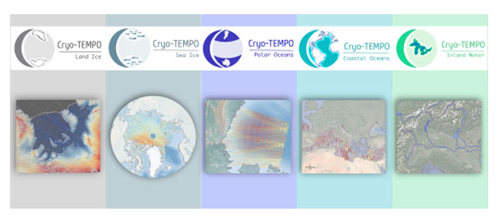
As of January 2022, ESA has started releasing new CryoSat-2 ThEMatic PrOducts (Cryo-TEMPO), dedicated to five distinct areas: Winter Sea Ice, Summer Sea Ice, Land Ice, Polar Oceans, Coastal Oceans and Inland Waters.
Developed within the frame of the Cryo-TEMPO activity, these products benefit from agile and state-of-the-art altimetry processing workflows, which utilise dedicated processing for each domain and optimise data fidelity across each thematic surface.
The simplified format and inclusion of fully traceable uncertainties are designed to make CryoSat-2 datasets accessible to new communities of scientific and service users, who traditionally may have lacked the technical expertise required to utilise previous products. To ensure this, a group of thematic non-altimetry experts has been integral in testing and providing feedback on the prototype datasets during the product design stage. Throughout the project, the products will be constantly evolved, and validated by the thematic experts, thus ensuring optimal relevance and impact for the intended target communities.
The products are developed by the Cryo-TEMPO consortium led by the UK Centre for Polar Observation & Modelling (CPOM), and the Lancaster University-UKCEH Centre of Excellence in Environmental Data Science (CEEDS).
The new Cryo-TEMPO product files cover the full duration of the CryoSat-2 mission, from 2010 to the present day. For information on how to access the data, see the CryoSat Products Download Page. Download the Cryo-TEMPO product handbook for a guide to these products. Further information can also be found on the project website.
CryoTEMPO EOLIS

The CryoTEMPO-EOLIS (Elevation Over Land Ice from Swath) is the first of the CryoTEMPO products and has been generated operationally since 7 May 2020.
The EOLIS products exploit CryoSat's SARIn mode and the novel Swath processing technique to deliver increased spatial and temporal coverage of time-dependent elevation over land ice, a critical metric for tracking ice mass trends. The dataset consists of systematic reprocessing of the entire CryoSat archive to generate new L2-Swath products, increasing data sampling by 1 to 2 orders of magnitude compared with the operational L2 Ice products. In addition, the EOLIS dataset is joined with the ESA L2 Point-Of-Closest-Approach to generate monthly Digital Elevation Model (DEM) products.
This dataset will further the ability of the community to analyse and understand trends across the Greenland Ice Sheet margin.
Two types of products are generated by CryoTEMPO EOLIS:
- CryoTEMPO EOLIS Point Products: Contain a dense set of elevation measurements for individual observations. Due to the high volume of data, the data has been split into tiles of 100 x 100 km in size.
- CryoTEMPO EOLIS Gridded Products: Contain monthly 2 km resolution DEM with the data sourced from a rolling three month window.
For more information on the format specification of EOLIS products, uncertainty indicators and data content, please download the EOLIS product handbook.
For more information about the project please visit the EOLIS website.
CryoSat Quaternions Product
The CryoSat Quaternions Product contains the attitude quaternions in the Geocentric Mean of 2000 Inertial Coordinate Frame for the CryoSat-2 mission. It is obtained starting from the corrected mispointing angles measured by the platform star trackers with regard to the nominal satellite reference frame.
Spacecraft attitude information can be used by the Precise Orbit Determination (POD) community to improve satellite orbit modelling and can serve as a reference to analyse platform deviations from the nominal theoretical orbit. More information on the product can be found in the Algorithm Description and Product Format Specification documents.
The Quaternions Product is generated operationally and is available for each day since July 2010. It is accessible through the CryoSat CalVal FTPS server via an FTPS client, and located in the “AUX_PROQUA” folder with an approximately 24-hour latency. Users wishing to access the quaternions products should request a personal account to be created by emailing the CryoSat Mission Geophysicist, Dr. Alessandro Di Bella (alessandro.di.bella@ext.esa.int).
The CryoSat-2 Quaternions Product complements the existing ESA GNSS & POD portfolio available at the Copernicus POD Hub.