- All Categories (263)
- Data (3)
- News (29)
- Missions (2)
- Events (10)
- Tools (4)
- Activities (6)
- Documents (209)
NEWS
Discover the latest news on the European Space Agency's Earth Observation activities. Learn all about new data availability and how ESA's missions are performing.
News - Data Release news
 5 Mar 2018
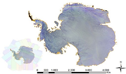
PROBA-V data available over Antarctica
Due to a huge amount of interest, it was decided to acquire PROBA-V data over Antarctica from November 2017 to February 2018.
News - Data Release news
 7 Mar 2019
PROBA-V 2018-2019 Antarctica data now available
For the second consecutive austral summer season, PROBA-V observed Antarctica and its ongoing changes.
News - Operational News
 15 May 2019
PROBA-V global land cover maps released
Copernicus Global Land Service team have released their new set of global land cover layers for the year 2015.
News - General News
 29 July 2019
Three new Third Party Missions under evaluation
ICEYE, PlanetScope and Spire under evaluation. Interested users can investigate suitability of the data for scientific and R&D activities.
News - Infographics
21 Apr 2020PROBA-V - ESA's vegetation monitoring mission
ESA's vegetation-monitoring mission - Proba-V - will end operations in June 2020 after seven years.
News - Operational News
 10 Aug 2020
New experimental phase for PROBA-V
PROBA-V has begun a new experimental phase that will continue through to October 2021.
News - Data Release news
 28 Sept 2020
Spire data now open to users
Following the submission of a project proposal, data from the Spire mission are now available.
News - General News
 29 Sept 2020
ESA’s Earth Observation Catalogue and its services
EO-CAT is the EO Catalogue tool allowing users to search ESA and Third Party Mission collections.
News - General News
 29 Sept 2020
ESA's new DataCube service is now available
ESA is pleased to announce the deployment of a new service, called ESA PDGS-DataCube, enabling multi-temporal and pixel-based access to a subset of the data available in the European Space Agency dissemination services.
News - Success Stories
 15 Mar 2021
1 km resolution aerosol optical thickness retrieved from PROBA-V
The ESA SPAR@MEP project aims to deliver a long-term data record (LTDR) of aerosol optical properties and surface reflectance from SPOT-VGT and PROBA-V observations.
News - General News
 29 Apr 2021
Quality Reports Advanced Search Portal takes off
The Quality Reports Advanced Search (QRAS) Portal is a system that provides a set of functionalities for searching, filtering, visualising and downloading of Earth Observation reports data, from multiple missions.
News - General News
21 June 2021Full version of QRAS Portal released
The new, full version, of the Quality Reports Advanced Search (QRAS) Portal launched today, adding new features to support users looking for Quality Control Reports on ESA and Third Party Missions.
News - Infographics
 23 Sept 2021
ESA Third Party Missions timeline
We've released a new timeline to illustrate the history of the ESA Third Party Missions.
News - General News
 26 Oct 2021
PROBA-V, ready to close its green eyes
While the operational lifetime of the global PROBA-V mission already ended on 30 June 2020 after more than 7 years in orbit, its vegetation instrument remained capturing the European and African land mass in experimental mode ever since.
News - Infographics
 8 Nov 2021
An overview of ESA's Third Party Missions programme
ESA’s Third Party Missions programme consists of almost 50 satellite missions, which are owned by organisations around the world. ESA has agreements with these organisations to acquire, process, and distribute data from their missions
News - Success Stories
10 Nov 2021Long-live PROBA-V
After eight years in space, the PROBA-V satellite ended its vegetation mission last 31 October, having gone well beyond expectations for global vegetation monitoring.
News - Success Stories
 13 Dec 2021
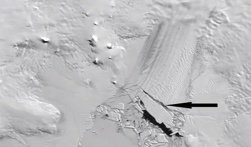
Ship trails in the Bay of Biscay observed using PROBA-V imagery
Ship trails have been perceived as convincing evidence of aerosol-cloud interaction. Ship emissions have been proven to contribute by about 1.9% and 2.9% to the increase in the global total and fine-mode aerosol optical thickness (AOT) respectively over a five year period (Peters et al. 20212).
News - Thematic area articles
 2 Feb 2022
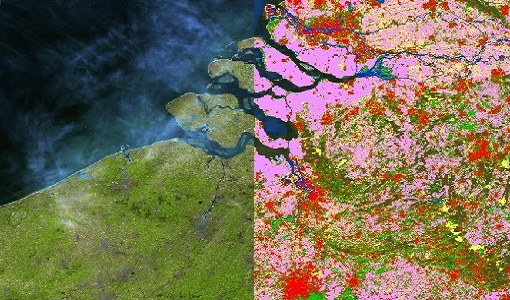
Satellite data boost global understanding of land surface
Understanding our changing land surface is essential in the study of climate change. Satellites are used to monitor changes to the material that covers Earth’s surface, so-called land cover, such as vegetation and water.
News - General News
14 July 2022Campaign using surface reflectance data to support validation of Earth observation products
Scientists from around the world are set to take part in a drone monitoring campaign and inter-comparison exercise that will deliver surface reflectance data to support the validation of Earth observation products.
News - Thematic area articles
9 Dec 2022Global understanding of Earth's land surfaces greatly boosted by satellite data
ESA perform land surface monitoring with a range of instruments onboard satellites acquiring optical and radar data. Collections of data from these missions are freely available for research purposes.