- Learn & Discover
- Ship trails in the Bay of Bisc...
Ship trails in the Bay of Biscay observed using PROBA-V imagery
13 Dec 2021
Ship trails have been perceived as convincing evidence of aerosol-cloud interaction. Ship emissions have been proven to contribute by about 1.9% and 2.9% to the increase in the global total and fine-mode aerosol optical thickness (AOT) respectively over a five year period (Peters et al. 2012).
The increased presence of the fine particles translates into the generation of Cloud Condensation Nuceleii (CCN), which produce smaller cloud droplets and affect the cloud albedo (Twomey effect, Twomey 1974). This effect known as the first indirect effect, increases the cloud albedo, resulting ultimately in a cooling effect. The area of the Bay of Biscay, being subject to heavy maritime traffic, has been studied in this regard using satellite data and model simulations. (Possner et al. 2015.)
In the framework of the ESA funded SPAR@MEP project, PROBA-V acquisitions over this region during 2019 at 1 km resolution have been processed with CISAR, an innovative algorithm for the consistent retrieval of surface reflectance, aerosol, and cloud single scattering properties.
4 April 2019 was a particularly clear day and the trails left by the ships in the Bay of Biscay are clearly visible from satellite images. CISAR retrieves the AOT and correctly identifies the high aerosol load as fine particles, as can be seen in the image below.
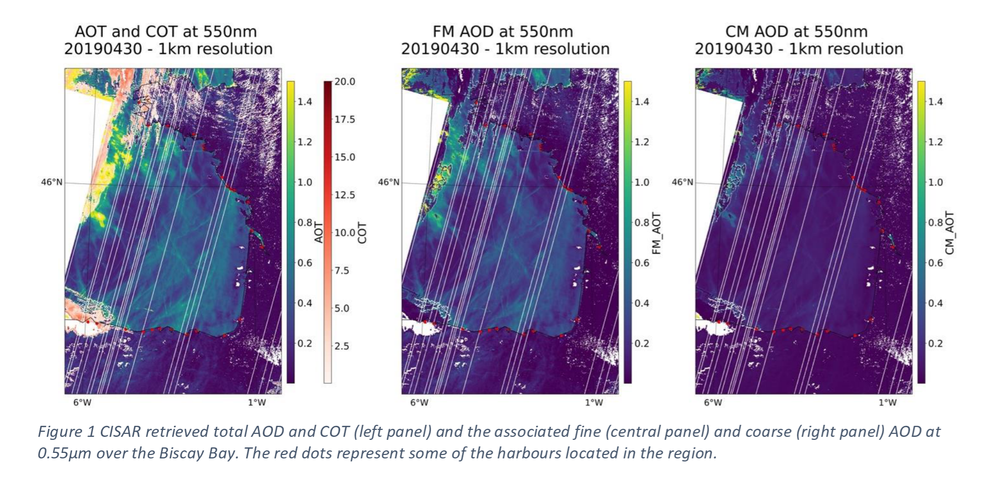
CISAR retrieved total AOD and COT (left panel) and the associated fine (central panel and coarse (right panel) AOD at 0.55 µm over the Bay of Biscay. The red dots represent some of the harbours located in the region.
This interesting case study demonstrates the capability of the CISAR algorithm to correctly differentiate between fine and coarse mode. Also, processing both aerosols and clouds, the CISAR algorithm could represent a powerful tool to study aerosol-cloud interactions, such as the Twomey effect, using high resolution satellite imagery.
References
- Peters et al. 2012. "Aerosol indirect effects from shipping emissions: sensitivity studies with the global aerosol-climate model ECHAM-HAM". Atmos. Chem. Phys., 12, 5985–6007, 2012 https://doi.org/10.5194/acp-12-5985-2012
- S. Twomey 1974. "Pollution and the planetary albedo". Atmospheric Environment Volume 8, Issue 12, December 1974, Pages 1251-1256 https://doi.org/10.1016/0004-6981(74)90004-3
- Possner et al. 2015. "Real-case simulations of aerosol–cloud interactions in ship tracks over the Bay of Biscay". Atmos. Chem. Phys., 15, 2185–2201, 2015 https://doi.org/10.5194/acp-15-2185-2015