- All Categories (72)
- Data (3)
- News (10)
- Missions (2)
- Events (12)
- Tools (5)
- Activities (2)
- Campaigns (1)
- Documents (37)
Event - Workshop

2nd CHRIS PROBA Workshop
This 2004 workshop was on the treatment of Compact High Resolution Images Spectrometer (CHRIS) data.
Event - Training

3rd Advanced Training Course on Land Remote Sensing 2011
This 2011 advanced ESA training course focused on land remote sensing theory and applications.
Event - Workshop
3rd CHRIS PROBA Workshop
This 2005 workshop was on the treatment of Compact High Resolution Images Spectrometer (CHRIS) data.
Event - Workshop
4th CHRIS PROBA Workshop
Workshop on the treatment of Compact High Resolution Images Spectrometer (CHRIS) data.
News - Success Stories
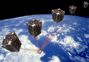
A long way for a little satellite
The PROBA-1 satellite, a technology demonstrator later turned into an Earth observation mission – and just a cubic metre in volume – is reaching 20 years of continuity, making it a huge success.
News - Infographics

A summary of ESA Third Party Mission collections
A new summary is available, showcasing the ESA archives for Third Party Mission collections.
Document - Technical Note

A-comparison-of-superresolution-reconstruction-methods-for-multiangle-CHRIS-Proba-images.pdf
This paper presents the results of three superresolution methods applied to multiangular CHRIS/Proba data: three methods, namely non-uniform interpolation and de-convolution, iterative back-projection, and total variation are examined.
Event - Training
Advanced Training Course in Land Remote Sensing 2012
The 2012 advanced training course focused on land remote sensing theory and applications.
Document - Proceedings

Advances-in-Atmospheric-Science-and-Applications.pdf
Proceedings in Advances in Atmospheric Science and Applications held in 18-22 June 2012 in Bruges, Belgium.
Document - Publication - Paper

Assessment of Canopy Structure and Heterogeneity from Multi-Angular CHRIS-PROBA Data
The spaceborne ESA-mission CHRIS-PROBA (Compact High Resolution Imaging Spectrometer-Project for On-board Autonomy) provides hyperspectral and multi-angular data of selected terrestrial targets (Barnsley et al. 2004). For vegetated surfaces, the spectral information content of CHRIS data may yield the biochemical and biophysical properties of a vegetation canopy, while the directional component may deliever additional information on its canopy structure. Here, the multi-angular CHRIS observations are investigated and related to surface structure using the parametric RahmanPinty-Verstraete (RPV) model.
Event - Conference

Atmospheric Science Conference 2006
The 2006 conference was dedicated the theme atmosphere to provide scientists and data users with the opportunity to present first-hand and up-to-date results from their ongoing research activities ESA Mission instruments.
Tools - Processing
Atmospheric Toolbox
The Atmospheric Toolbox (previously known as BEAT) is a collection of executable tools and API, developed to facilitate the utilisation, viewing and processing of e.g. GOMOS, MIPAS, SCIAMACHY and GOME data.
Mission - Third Party Missions

Aura
NASA's Aura mission studies the chemistry and dynamics of Earth's atmosphere from the ground through the mesosphere.
Data - External Data (Restrained)
Aura OMI complete NASA dataset
The OMI observations provide the following capabilities and features: A mapping of ozone columns at 13 km x 24 km and profiles at 13 km x 48 km A measurement of key air quality components: NO2, SO2, BrO, HCHO, and aerosol The ability to distinguish between aerosol types, such as smoke, dust and sulfates The ability to measure aerosol absorption capacity in terms of aerosol absorption optical depth or single scattering albedo A measurement of cloud pressure and coverage A mapping of the global distribution and trends in UV-B radiation. The OMI data are available in the following four levels: Level 0, Level 1B, Level 2, and Level 3. Level 0 products are raw sensor counts. Level 0 data are packaged into two-hour "chunks" of observations in the life of the spacecraft (and the OMI aboard it) irrespective of orbital boundaries. They contain orbital swath data. Level 1B processing takes Level 0 data and calibrates, geo-locates and packages the data into orbits. They contain orbital swath data. Level 2 products contain orbital swath data. Level 3 products contain global data that are composited over time (daily or monthly) or over space for small equal angle (latitude longitude) grids covering the whole globe.
Document - General Reference

Autonomy-in-action-Ten-years-of-Proba-1.pdf
This is an article extracted from the ESA Bulletin Nr.148.
Document - General Reference
Big-year-for-small-satellite-ESAs-second-in-orbit-technology-demonstration-mission-Proba-2.pdf
This is an article extracted from the ESA Bulletin Nr.144.
Document - General Reference
BIOMASS-Report-for-Mission-Selection-An-Earth-Explorer-to-observe-forest-biomass.pdf
The objective of the BIOMASS Mission is to determine the global distribution of forest biomass by reducing the uncertainty in the calculation of carbon stock and fluxes associated with the terrestrial biosphere.
News - Events and Proceedings
Celebrating ESA’s first small satellite with science success
Scientists and data users gathered at a special workshop to celebrate the end of PROBA-1’s CHRIS sensor and discuss the results of this overachieving mission.
Event - Workshop
CEOS-IVOS Workshop on Inter-comparison of Large Scale Optical and Infrared Sensors
The 2004 workshop was an opportunity to present and exchange experiences and knowledge from work on inter-comparing large scale optical sensors at different product levels.
Data - Announcement of Opportunity (Restrained)

Closed ESA announcement of opportunities
Find out about closed ESA announcement of opportunities and what these opportunities involved, for historical reference.