- All Categories (41368)
- Data (49)
- News (153)
- Missions (21)
- Events (50)
- Tools (6)
- Activities (10)
- Campaigns (11)
- Documents (41068)
News - Events and Proceedings

Φ-Week Triumphs
In its fourth edition, Φ-Week presented the scientific community with amazing opportunities and projects—thus running alongside innovation at 360 degrees.
News - Success Stories
Young scientists bid farewell to ESA's wind mission
Students and early career researchers are saying an emotional goodbye to Aeolus ahead of its upcoming reentry.
News - Success Stories
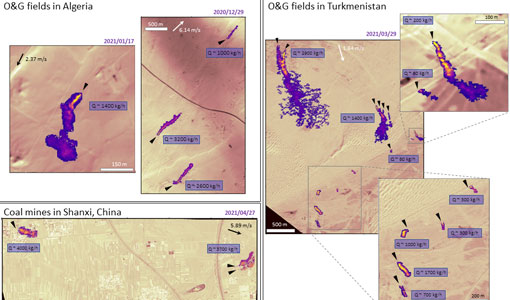
WorldView-3 satellite maps methane plumes at very high spatial resolution
Substantial advances have been made in the last years towards the detection and quantification of methane emissions from space- very high spatial resolution data from the WorldView-3 satellite can fill an important observational gap in the remote sensing of methane point emissions.
News - Success Stories

WorldView-3 helps to track offshore methane plumes from oil and gas
Scientists have used Earth observation data to reveal enormous methane plumes spilling out from an offshore oil and gas production rig in the Gulf of Mexico. This represents a significant breakthrough in the monitoring of industrial methane emissions from space.
Data - Project Proposal (Restrained)

WorldView-2 European Cities
ESA, in collaboration with European Space Imaging, has collected this WorldView-2 dataset covering the most populated areas in Europe at 40 cm resolution. The products have been acquired between July 2010 and July 2015. Spatial coverage: Check the spatial coverage of the collection on a map available on the Third Party Missions Dissemination Service.
Event - Conference

World Soils 2019 User Consultation Meeting
The World Soils 2019 User Consultation Meeting focussed on space-based EO tools for mapping and monitoring soils. The meeting brought together stakeholders and remote sensing experts.
Event - Meeting

World Ocean Circulation User Consultation Meeting 2019
The World Ocean Circulation User Consultation Meeting took place in 2019 with the aim to prepare a roadmap for new initiatives on ocean circulation research and applications.
News - Success Stories
Vision-1 to enable cutting-edge science and spur innovation
Vision-1 – which is the result of a collaboration between Airbus Defence and Space and Surrey Satellite Technology Ltd. (SSTL) – provides sub-metric imagery to support activities across many industries, including urban planning, agricultural monitoring, land classification, natural resource management and disaster monitoring.
Data - Project Proposal (Restrained)
Vision-1 full archive and tasking
Vision-1 provides very high resolution optical products, with 87cm resolution in Panchromatic mode and 3.48m in Multispectral Mode. Products are in DIMAP format; the image is in GeoTiff format with 16 bit encoding; the applied geographical projection is WGS84 UTM. Spectral band combination options: Panchromatic (PAN): includes data contained within a single high resolution black and white band, with product pixel size of 0.87m Multispectral (MS4): includes four multispectral (colour) bands: Blue, Green, Red and Near Infrared. The product pixel size is 3.48m Bundle (BUN): provides both the 4-band multispectral, and the panchromatic data from the same acquisition in a single, non-merged product. Data is provided as 16-bit GeoTiffs with pixel sizes of 3.48m and 0.87m for MS and PAN data respectively Pansharpened (PSH): single higher resolution 0.87 colour product obtained by the combination of the visual coloured information of the multispectral data with the details provided in the panchromatic data. Two different geometric processing levels are: Projected (level 2): The product is mapped onto the Earth cartographic system using a standard reference datum and projection system at a constant terrestrial altitude, relative to the reference ellipsoid. By default, the map projection system is WGS84/UTM. The image is georeferenced without the application of a Digital Elevation Model (DEM) and supplied with the RPC model file. Pansharpened are not available as projected product Standard Ortho (level 3): georeferenced image in Earth geometry, including the application of a Airbus World DEM for Ortho and GCPs (using Airbus Intelligence One Atlas BaseMap as reference). The orthorectification procedure eliminates the perspective effect on the ground (excluding buildings) to restore the geometry of a vertical shot. Only the basic radiometric processing is available providing the radiance value. As per ESA policy, very high-resolution imagery of conflict areas cannot be provided.
News - Data Release news
Vision-1 data now open to users
In the framework of the Third Party Missions programme, ESA is offering, for scientific research and application development, access to archive and new tasking data from the Vision-1 mission upon submission and acceptance of a project proposal.
Mission - Third Party Missions
Vision-1
Launched on 16 September 2018, Vision-1 offers orthorectified products with resolution up to 87 cm in panchromatic mode and 3.48 in multispectral mode as standard.
Document - User Guide

User's Guide to NASDA's SAR products
This document summarises the algorithms to obtain geometric and radiometric information from NASDA's JERS SAR products. It includes a list of the physical information to be derived from the JERS SAR products. Not applicable for JERS SAR data generated by ESA (only for NASDA data).
Document - User Guide
User Guide for JERS-1 SAR data format
This document describes the Computer Compatible Tape (CCT) format and the film format for JERS-1's Synthetic Aperture Radar (SAR) data process in EOC. The EOC's CCT product conforms to the CEOS SAR data products format Standard.
Event - Workshop
URBIS24
URBan Insights from Space (URBIS24) Workshop will offer an insightful exploration of urban challenges and innovative EO-integrated solutions.
News - Data Release news

Updated Precise Orbit data (POD) for the full ERS-1 and ERS-2 mission available
The Precise Orbit files (ERS.ORB.POD) for the entire ERS-1 and ERS-2 mission periods have been reprocessed with up-to-date standards.
News - Data Release news

Updated CryoSat magnetometer data now available with new baseline 0201
An improved version of the CryoSat magnetic field data is now available on the Swarm Dissemination Server with new baseline 0201.
News - Operational News

Update on Swarm Field-Aligned Current Dual (FAC_AC) data missing from 7 November 2021
As a follow-up of the news published on 23 November 2021, we want to update Swarm users about the missing Field-Aligned Current Dual (FAC_TMS_2F) data since 7 November 2021.
Event - Workshop

Understanding the Carbon and Water Cycles using SMOS Data and Models
The workshop aimed to bring together the EO, SMOS, Earth system science and modelling communities involved in the observation, characterisation and forecasting of land surface processes and their impacts.
Document - General Reference

Understanding climate change from space
This document describes ESA's Climate Change Initiative, and how it is intended to contribute towards monitoring and understanding the Earth's climate.
News - Thematic area articles

Transforming space data into climate action
ESA’s Earth observation activities are playing a key role in the revitalised global drive to combat climate change.