- News
- Vision-1 to enable cutting-edg...
Vision-1 to enable cutting-edge science and spur innovation
17 May 2022
Remote sensing scientists are set to use an archive of very detailed Earth observation imagery to complete a new series of innovative research and development projects, thanks to ESA’s drive to distribute high-quality data delivered by numerous international missions.
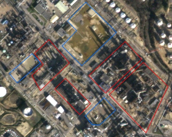
Vision-1 – which is the result of a collaboration between Airbus Defence and Space and Surrey Satellite Technology Ltd. (SSTL) – provides sub-metric imagery to support activities across many industries, including urban planning, agricultural monitoring, land classification, natural resource management and disaster monitoring.
Its archives have been added to ESA’s Third Party Missions programme an initiative that fosters international collaborations to promote the delivery of accessible Earth observation data, supporting cutting-edge science and the development of a wide range of operational applications.
Vision-1 imagery is collected by SSTL’s S1-4 satellite, which launched in September 2018, onboard the Polar Satellite Launch Vehicle from the Satish Dhawan Space Centre in India. The portion of S1-4 imaging capacity that is dedicated to Vision-1 is owned by Airbus and operated in partnership with SSTL.
It uses several imaging modes to provide highly detailed imagery in the panchromatic band (87 cm resolution) and multispectral bands (3.48 m resolution), with a swath width of 20.8 km and a global revisit time of 1 to 8 days.
These high-resolution data combined with the satellite’s rapid revisit capability make Vision-1 highly suited to the remote monitoring of key industrial and environmental sites, where in-situ tracking may be impractical.
Vision-1 can reveal in detail how these areas are changing, helping to guide environmental management efforts, as well as supporting supply chain analysis and facilitating market intelligence in a number of industries.
First, a base map of the area of interest can be generated from plans or local knowledge, then historic imagery of the area is used to train predictive models of activity levels. The site can then be monitored on a regular basis, with advanced analytics algorithms helping to detail changes in activity over time.
In addition, the ability of Vision-1 to provide very detailed imagery at high-frequency intervals is playing an important role in efforts to tackle urgent global challenges.
Along with a number of Earth observation missions, Vision-1 makes active contributions to the International Charter for Space and Major Disasters, which delivers free and timely satellite data to accelerate humanitarian responses to natural and human-induced catastrophes.
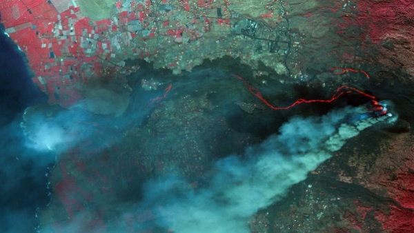
In autumn 2021, for instance, Vision-1 helped to monitor the impacts of a volcanic eruption on the Spanish island of La Palma, in the Canary Islands. Lasting from 19 September to 13 December 2021, the eruption emanated from the Cumbre Vieja volcanic ridge, comprising the southern half of the land mass.
Other crises that have been tracked by Vision-1 include an oil spill that occurred off the coast of Peru in January 2022, a tropical cyclone that severely impacted Timor-Leste in Southeast Asia in April 2022, and the eruption of the Semeru volcano in Indonesia that took place last year.
Apply for Vision-1 data by submitting a Project Proposal. Find out more.