- Learn & Discover
- WorldView-3 satellite maps met...
WorldView-3 satellite maps methane plumes at very high spatial resolution
23 Jun 2021
Substantial advances have been made in the last years towards the detection and quantification of methane emissions from space— very high spatial resolution data from the WorldView-3 satellite can fill an important observational gap in the remote sensing of methane point emissions.
Recent work by the Land and Atmosphere Remote Sensing (LARS) group at the Universitat Politècnica de València (UPV) has led to the latest breakthrough in this quickly developing field.
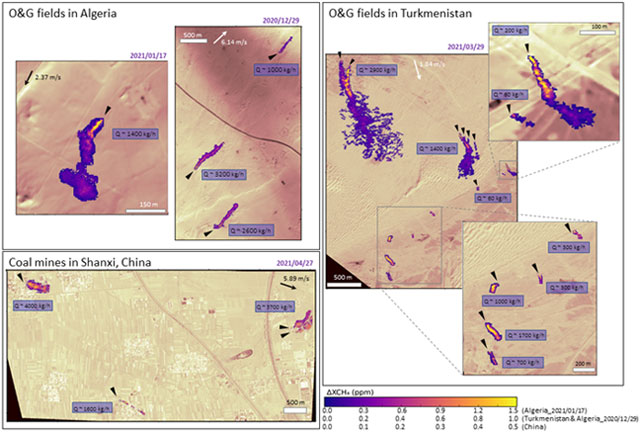
Using very high spatial resolution shortwave infrared (SWIR) images from the WorldView-3 satellite, they have mapped methane plumes from a number of locations around Earth at a spatial resolution up to 3.7 m. Positive plume detections were achieved in oil and gas extraction fields in Algeria and Turkmenistan, and in the Shanxi coal mining region in China.
An ESA Third Party Mission, WorldView-3 is an imaging and environment-monitoring satellite from DigitalGlobe of the United States, which launched on 13 August 2014 and remains operational.
It covers a ground swath of 13.1 km, supporting multiple swath imaging for mosaic image creation and stereo imaging. With its high agility, WorldView-3 delivers a revisit time of under one day for any given location on Earth, with a 3.7 m ground resolution for nadir SWIR images. The high spatial and temporal resolution of WorldView-3 SWIR observations are complemented with a high signal-to-noise ratio and a good spectral coverage of the strong methane absorption around 2300 nm, which make it a powerful mission for methane mapping.
Until now, methane retrievals at such high resolution were only possible for airborne instruments, like the AVIRIS-NG spectrometer operated by NASA’s Jet Propulsion Laboratory. WorldView-3's very high resolution SWIR images are thus an important complement to the current set of satellite missions capable of methane plume mapping, which share a spatial sampling in the 20-30 m range.
These include the GHGSat satellite constellation, which enables the detection of a large number of anthropogenic methane emissions around the world, the so-called imaging spectrometers (also known as hyperspectral imagers), and multispectral missions such as Copernicus Sentinel-2 and Landsat.
These high resolution imagers greatly benefit from the synergistic use of the TROpospheric Monitoring Instrument (TROPOMI) onboard the Copernicus Sentinel-5 Precursor satellite, to identify regions with strong methane concentration enhancements on which the high resolution missions can focus for the detection of single emitters.
Mapping methane emissions with WorldView-3’s very high spatial resolution has a ground-breaking potential. For instance, methane concentration maps from WorldView-3 allow a substantial improvement of emission detection thresholds, as smaller emissions can be unveiled and precisely located.
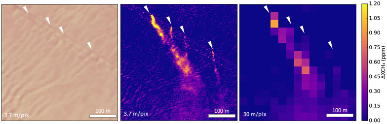
A more precise quantification of emission rates and the accurate identification of the particular infrastructure elements responsible for the emissions also benefit strongly from the unprecedented spatial resolution improvement enabled by WorldView-3. On the other hand, further work is needed to reduce the impact of the surface background on the methane concentration enhancement maps derived from WorldView-3.
This problem is common to other missions, but it becomes critical in this case because of the higher variability of the surface at WorldView-3’s 3.7 m sampling.
Luis Guanter, Head of the LARS group at UPV’s Research Institute of Water and Environmental Engineering, affirms, “Detecting and fixing fugitive methane emissions from fossil fuel production activities worldwide has been identified as a key climate change mitigation strategy. Satellite observations are becoming an essential means for this endeavour”.
Elena Sánchez-García, also from LARS group, adds, “From now on, WorldView-3 will greatly contribute to this task, by enabling methane plume mapping at the highest spatial resolution of all available methane-sensitive satellite systems to date.”