- Learn & Discover
- How satellite data help to sha...
How satellite data help to shape society
29 Sep 2022
Data from ESA’s Earth observation archives are improving understanding of the interactions between human activities and the environment, helping to power green economic development and boosting prosperity in Europe and beyond.
Scientists and researchers are putting this information to work across society, promoting food security, the responsible use of natural resources, sustainable urban growth, and much more.
These applications are accelerating a green transition for the European economy, as the international community rejuvenates its efforts to tackle the climate crisis.
What are human dimensions?
The impact of human activities – such as the cultivation of agricultural land, the consumption of natural resources, and the development of infrastructure – are monitored by a range of space-borne sensors carried by remote sensing missions. The human dimensions of Earth observation refer to how these data are used to inform the decisions of governments, communities and industry, for the benefit of society and the environment.
Data for human dimensions
ESA has been tracking the impact of human activities on the planet for decades, thanks to a succession of remote sensing missions.
These consist of several Heritage Missions, including ESA’s European Remote Sensing satellite (ERS) programme – which was active between 1991 and 2011 – and the agency’s Envisat satellite, which was launched in 2002 and delivered 10 years of data.
Following missions such as ERS and Envisat, ESA is continuing to advance understanding of how Earth works as a system through a family of research missions, called the Earth Explorers.
As part of ESA’s Third Party Missions Programme, the agency also disseminates high-quality Earth observation data delivered by partner missions from around the world.
Data from Heritage, Earth Explorer, and Third Party missions – which are available for free for research purposes – are contributing strongly to the human dimensions of Earth observation, supporting decision making in many industries, for the benefit of society and the environment.
Reinforcing food security
Space data are playing a key role in helping farmers cope with the dual challenges of climate and population increase.
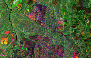
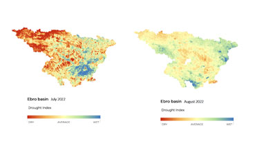
In a recent activity, for example, scientists developed a drought monitor that was used to investigate wheat production in Europe. The research drew on data delivered by ESA’s SMOS satellite, which is part of the Earth Explorers programme.
Focusing on farms in Spain during the most recent growing season, the monitor showed that a period of drought – which coincided with a critical crop growth stage – was an important indicator of reduced yields at harvest.
As climate change fuels an increase in the severity and frequency of droughts, results from the monitor will help farmers and agribusinesses develop anticipation and adaption measures.
In a separate activity, researchers used high-resolution data from the PlanetScope constellation – which is part of ESA’s Third Party Missions programme – to predict crop yields of small farms in sub-Saharan Africa, helping to promote food security in the region.
The results from the research – which also drew on imagery from Copernicus Sentinel-2 – were impressive, forecasting yields with a high level of confidence. This information could help the government target support to regions experiencing low yields.
Sustainable urban development
As cities around the world continue to expand to accommodate the rising global population, city planners are using satellite data to promote sustainable urban expansion.
In recent research, optical imagery and synthetic aperture radar data helped scientists investigate how urban footprints change over decades. This is essential to ensure infrastructure development doesn’t negatively impact the environment or create urban sprawl.
As part of the research – which focused on Limassol in Cyprus, Rotterdam in the Netherlands, and Liège in Belgium – Heritage data collected by ERS-1 and ERS-2, as well as data from other missions, were used to train a neural model that revealed how cities expanded over long periods.
In addition, several Third Party Missions deliver data to support urban planning and development, including Vision-1, ICEYE, and Pléiades Neo.
Tracking natural resources
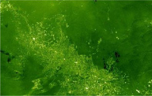
Data from remote sensing missions are being used to monitor key natural resources, such as the world’s forests.
Early ESA Heritage missions helped to shape understanding of the changes impacting the planet’s forests, with Envisat and ERS delivering valuable data on deforestation in the Amazon basin in the 1990s and 2000s.
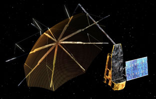
An upcoming Earth Explorer mission called Biomass – which is expected to launch in 2023 – is set to provide further insight into the state of forests and how they are changing, using a novel P-band synthetic aperture radar instrument.
The use of other environmental resources – such as natural gas – is also being tracked using Earth observation data.
Research published this year that drew on remote sensing data revealed enormous methane plumes spilling out from an offshore oil and gas production rig in the Gulf of Mexico, representing a significant breakthrough in the tracking of industrial methane emissions from space.
The analysis used data from the WorldView-3 satellite, which were delivered on a free basis via ESA’s Third Party Missions programme. It also drew on imagery collected by the US-led Landsat-8 mission.
The project demonstrated how satellite data can be used to produce actionable information about methane plumes from offshore infrastructure. This could help to inform strategies to reduce these emissions, contributing to global efforts to address the climate crisis.
How can we detect deforestation?
Thanks to their unique vantage point, numerous remote sensing satellites have been tracking deforestation around the world for decades. These missions collect a range of data, including optical imagery as well as synthetic aperture radar data, which have the advantage of penetrating cloud cover. Forest-monitoring satellites are playing an important role in slowing deforestation, by raising public awareness and providing actionable information to governments and businesses.
Accelerating recoveries
Satellite data are also supporting society in its efforts to adapt to the impacts of a changing climate.
As the frequency and severity of extreme weather events increase, Earth observation missions are helping communities recover from these crises by providing timely information to the insurance industry.
The Spanish PAZ satellite – also a Third Party Mission – collects synthetic aperture radar data with a ground resolution up to 25 cm at a rate of around 100 images per day.
By contrasting images of affected areas before and after a disaster, scientists can determine its impact on infrastructure and the environment – this information benefits many industries, including insurance and civil protection.
Other Third Party Missions to provide data to the insurance industry include the PlanetScope constellation, the RapidEye constellation, and the WorldView constellation.