- Learn & Discover
- Predicting crop yield using Pl...
Predicting crop yield using Planet data
05 May 2022
The world’s population continues to grow, while the climate crisis is raising Earth’s temperatures and increasing the likelihood of extreme weather events – all of which affect food security.
Smallholder farms, such as those in drylands of sub-Saharan Africa, are at particular risk of losing cropland productivity. In order to support more sustainable agriculture policies, accurate, high resolution satellite data are essential.
Researchers have leveraged high spatial resolution data from Planet to help predict cropland yields in smallholder farming in Malawi to support food security policy.
Planet Labs PBC (NYSE: PL), has recently announced that Planet’s PlanetScope and SkySat data have joined ESA’s (European Space Agency) Third Party Missions programme. Through ESA’s Earthnet Programme, European researchers, scientists and companies can access Planet’s high-frequency, high-resolution satellite data for non-commercial use.
ESA is offering, for scientific research and application development, access to data from the full archive of the Planet missions upon submission and acceptance of a project proposal. These products are available as part of the Planet imagery offering.
One research group from the University of Southampton led the BRECcIA project, funded through the UK’s Global challenge Research Fund, to use the high resolution data from Planet to study the capacity for sustainable water and food security in the drylands of sub-Saharan Africa.
The researchers at Southampton wanted to get a better understanding of the current state of croplands and their spatial variation in Malawi. At present, such information is either unavailable or available at a very coarse spatial detail.
The goal was to monitor smallholder farming systems by utilising crop and hydrology models to estimate yields. This information would be used to help locals and policymakers identify underperforming fields – i.e. fields that have lower yields than expected.
“Agriculture policymakers need accurate information on crop yield, so once we have a framework in place, this will feed into the agriculture monitoring in Malawi and support intervention programmes to increase productivity, ” says Dr Jadu Dash, Professor of Remote Sensing, Geography and Environmental Science, at the University of Southampton.
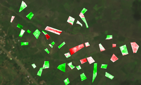
To accurately estimate crop productivity, the researchers leveraged near-daily PlanetScope Third Party Mission data in addition to Copernicus Sentinel-2 data, to create a statistical model of crop yield estimates. They also used on-the-ground field teams to verify the accuracy of the data collected by the satellites. The PlanetScope data bridged the scale gap between field measurements and satellite data observations from Copernicus Sentinel-2.
The team needed high-frequency, high-resolution data to study the smaller parcels of agricultural land in Malawi during a cloudy growing season. For this study, they specifically focused on maize crops. Their approach required many data points over time for a more comprehensive look at the crop growing season on the ground. They also needed higher-resolution data to gather more detailed field data, such as size, biomass and harvest index to create a statistical model to estimate maize crop yields. “Originally, we used Copernicus Sentinel-2 data, but some of the fields were quite small and there was a lot of inter-crop area. This is why we used PlanetScope data with a higher resolution as an intermediate data layer, in order to improve our prediction of crop yields,” explains Professor Dash.
“The temporal coverage of PlanetScope is another benefit. Since we wanted to study the phenology of the crops, we needed a lot of monitoring points across time.”
The results from the research were impressive, showing up to 60% level of confidence in the accuracy of predicting crop yields across smallholder farms in Malawi. The research also demonstrated how Planet and Copernicus Sentinel-2 data can support the identification of low-yield crop fields, which need governmental support.
In turn, this would aid the development of agricultural policies, which can improve food security in vulnerable regions such as Malawi.