 Asset Publisher
Borneo Deforestation 2012Borneo is one of the largest islands in the world, only Greenland and New Guinea have a greater land mass. The images featured in this article showcase Sabah State which is located in the northern part of the island. 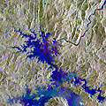
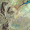
Serra de Mesa Dam, BrazilThis image, created with a merge of ERS-2 and Envisat satellite images, shows the Serra da Mesa Dam, in Brazil. The Serra da Mesa Dam was built to serve a hydroelectric power plant and forms the largest reservoir in Brazil. Construction of the dam and power station began in 1986, and on 24 October 1996 the dam began to inundate with water from the Tocantins River. 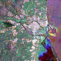
Valencia, SpainThis multi-temporal image, acquired over the city of Valencia (one of the largest cities in Spain), shows the urban development over a period of seven years along the Tura River. The image is a result of a merge of three separate acquisitions performed by the Envisat satellite (07 Aug 2010 in red, 18 Oct 2003 in green) and by ERS-2 (04 Nov 2011 in blue). 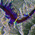
Three Gorges Dam, ChinaThis multi-temporal image, created by merging three separate images acquired by the Envisat and ERS-2 satellites, shows the Three Gorges Dam. It is a hydroelectric dam built along the Yangtze River near the town of Sandouping, located in the Yiling District of Yichang, in Hubei province, China. 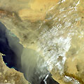
Sandstorm in Yemen and Saudi ArabiaA powerful sandstorm blew over the Persian Gulf in March 2012. The storm caused hundreds of people to go to the hospital for respiratory problems, and air traffic was disrupted for the duration of the storm. 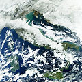
Italy covered with snow - February 2012This series of Envisat images, acquired by the MERIS instrument, show the heavy snow that fell over Italy in February 2012. 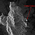
Giglio Island, Italy (Cruise ship accident) - January 2012This series of Envisat radar images examine Giglio Island, where the Costa Concordia cruise ship ran aground on 13 January 2012. 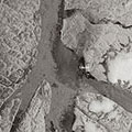
Petermann Glacier, GreenlandThese Envisat images, acquired by the ASAR and MERIS instruments, show the progression of the giant iceberg calved along the Nares Strait from the Petermann glacier in northern Greenland, one of the largest of the country's glaciers. 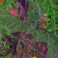
Brazil deforestation - August 2006These two Envisat images examine an area of deforestation in the Mato Grosso region of Brazil, utilising multi-layer compositions to track changes over time. 
B-15A iceberg monitoring - Antarctica (2004-2006)This series of Envisat images monitor iceberg B-15A from November 2004 to February 2006. B-15A was a fragment of the largest iceberg in recorded history and broke apart during 2005. |
||