 Asset Publisher
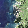
Saemangeum Dam - South KoreaThis series of images from the ERS-1/2, Envisat and Landsat satellites features Saemangeum Dam on the coast of the Yellow Sea in South Korea. The images follow the development of the area from 1987 to 2013. 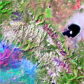
Yosemite National Park (California, USA) - Fire, September 2013These multispectral images acquired by the Landsat 8 satellite over the Yosemite National Park in California, show the large fire that broke out in the park on 20 August 2013. 
Dubai grows on the seaDubai is a city in the United Arab Emirates, located within the emirate. The emirate of Dubai is located on the southeast coast of the Persian Gulf and is one of the seven emirates that make up the country. It has the largest population in the UAE (2,106,177) and the second-largest land territory by area (4,114 km2) after Abu Dhabi, the national capital. 
Kansai and Kobe International Airport (Osaka Bay, Japan)Kansai International Airport is located on an artificial island in the middle of Osaka Bay, 38 km southwest of Osaka Station, located within three municipalities, including Izumisano (north), Sennan (south) and Tajiri (central) in Osaka Prefecture, Japan. 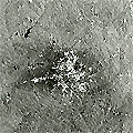
Kumasi, Ashanti Region (Ghana)Kumasi is the capital city of the Ashanti region, a very important and historical centre for Ghana. Kumasi is located near Lake Bosumtwi, in a rainforest region, and is the commercial, industrial and cultural capital of Asanteman. Kumasi is approximately 480 km north of the Equator and 60 km north of the Gulf of Guinea. Kumasi is alternatively known as "The Garden City" because of its many beautiful species of flowers and plants. 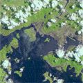
Hong Kong International AirportHong Kong International Airport is the main airport in Hong Kong. It is colloquially known as Chek Lap Kok Airport, being built on the island of Chek Lap Kok by land reclamation, and also to distinguish it from its predecessor, the closed Kai Tak Airport. 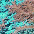
Lhonak Glacier (Sikkim Region, India)This series of images from the ERS and Envisat satellites, as well as Landsat 5 and 7, and ALOS, show a glacial lake that has formed atop the Himalayas in India. 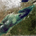
Algal blooms in Lake Erie (North America)The green scum shown in these images is the worst algae bloom Lake Erie has experienced in decades. Such blooms were common in the lake's shallow western basin in the 1950s and 60s. Phosphorus from farms, sewage, and industry fertilised the waters so that huge algae blooms developed year after year. 
Algal blooms phenomenon (Baltic Sea)These satellite images, acquired from Envisat's MERIS_FR sensor, show a vast algal bloom that could pose a risk to marine life in the Baltic Sea. The blue-green bloom, which stretches from Finland to parts of Germany and Poland, is the largest scientists have seen in the Baltic in recent years. They believe a prolonged stretch of warm sea temperatures and a lack of wind, coupled with fertiliser from regional agriculture washing into the Baltic, have caused the bloom. 
Athabasca Oil Sands (Alberta State, Canada)The Athabasca Oil Sands are large deposits of bitumen, or extremely heavy crude oil, located in north-eastern Alberta, Canada roughly cantered around the boomtown of Fort McMurray. These oil sands, hosted in the McMurray Formation, consist of a mixture of crude bitumen (a semi-solid form of crude oil), silica sand, clay minerals, and water. |
||