Hong Kong International Airport is the main airport in Hong Kong. It is colloquially known as Chek Lap Kok Airport, being built on the island of Chek Lap Kok by land reclamation, and also to distinguish it from its predecessor, the closed Kai Tak Airport. The airport opened for commercial operations in 1998, replacing Kai Tak, and is an important regional trans-shipment centre, passenger hub and gateway for destinations in Mainland China (with over 40 destinations) and the rest of Asia. HKIA also operates one of the world's largest passenger terminal buildings (the largest when opened in 1998) and operates 24 hours a day. The airport is operated by the Airport Authority Hong Kong and is the primary hub for Cathay Pacific, Dragonair, Hong Kong Airlines, Hong Kong Express Airways and Air Hong Kong (cargo). The airport is also one of the Asian-Pacific cargo hubs for UPS Airlines. It is a focus city for many airlines, including China Airlines and China Eastern Airlines, which serves 18 flights to Hong Kong per day (one direction) from 15 cities. Virgin Atlantic, United and Air India use Hong Kong as a stopover point for flights respectively from London to Sydney, from Tokyo to Singapore and Ho Chi Minh City as well as from India to Osaka and Seoul. HKIA is an important contributor to the Hong Kong economy, employing approximately 60,000 people. About 90 airlines operate flights from the airport to over 150 cities across the globe. In 2011 HKIA handled 53,314,213 passengers, making it the 10th busiest airport worldwide by passenger traffic.It also surpassed Memphis International Airport to become the world's busiest airport by cargo traffic.
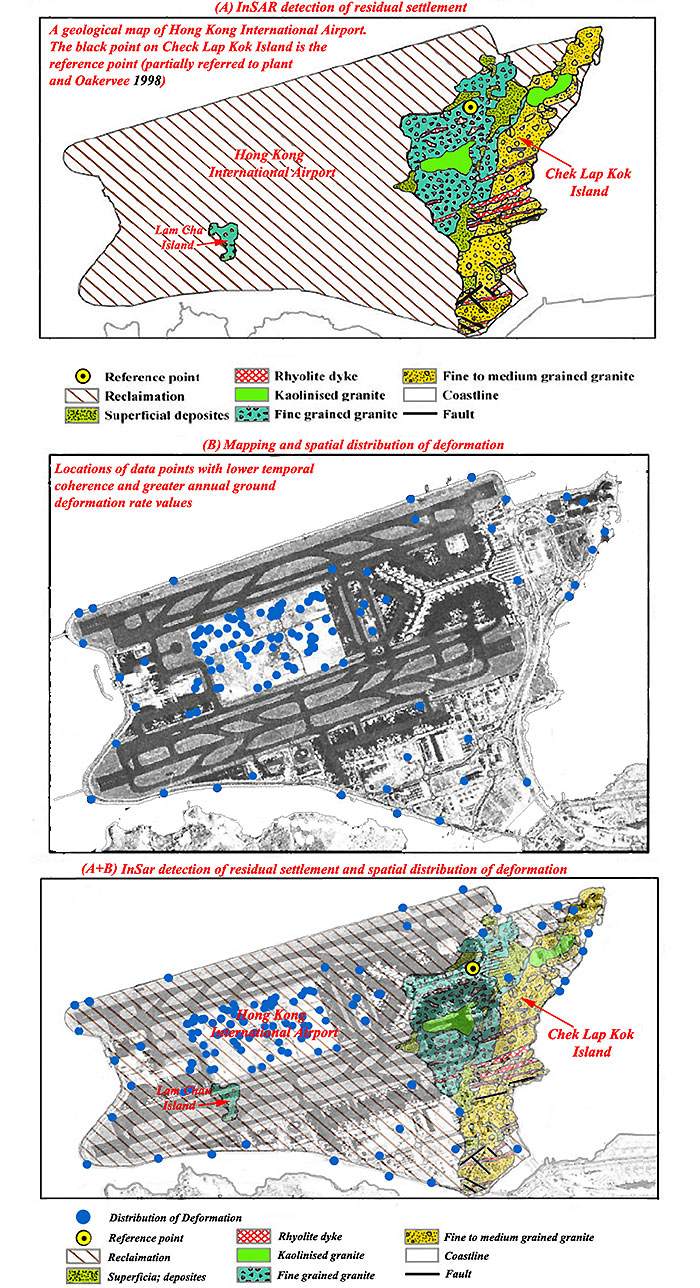
ISAR detection of residual settlement of an ocean reclamation engineering project: A case study of Hong Kong International Airport (by Q. Zhao, H. Lin, W. Gao, Howard A. Zebker, A. Chen, K. Yeung)
For more information, view the report (PDF)
|
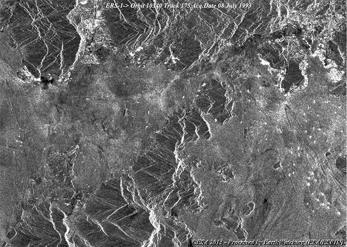
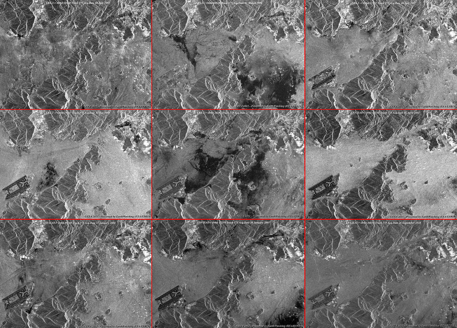
ERS-1/2 and Envisat swath2 animation |
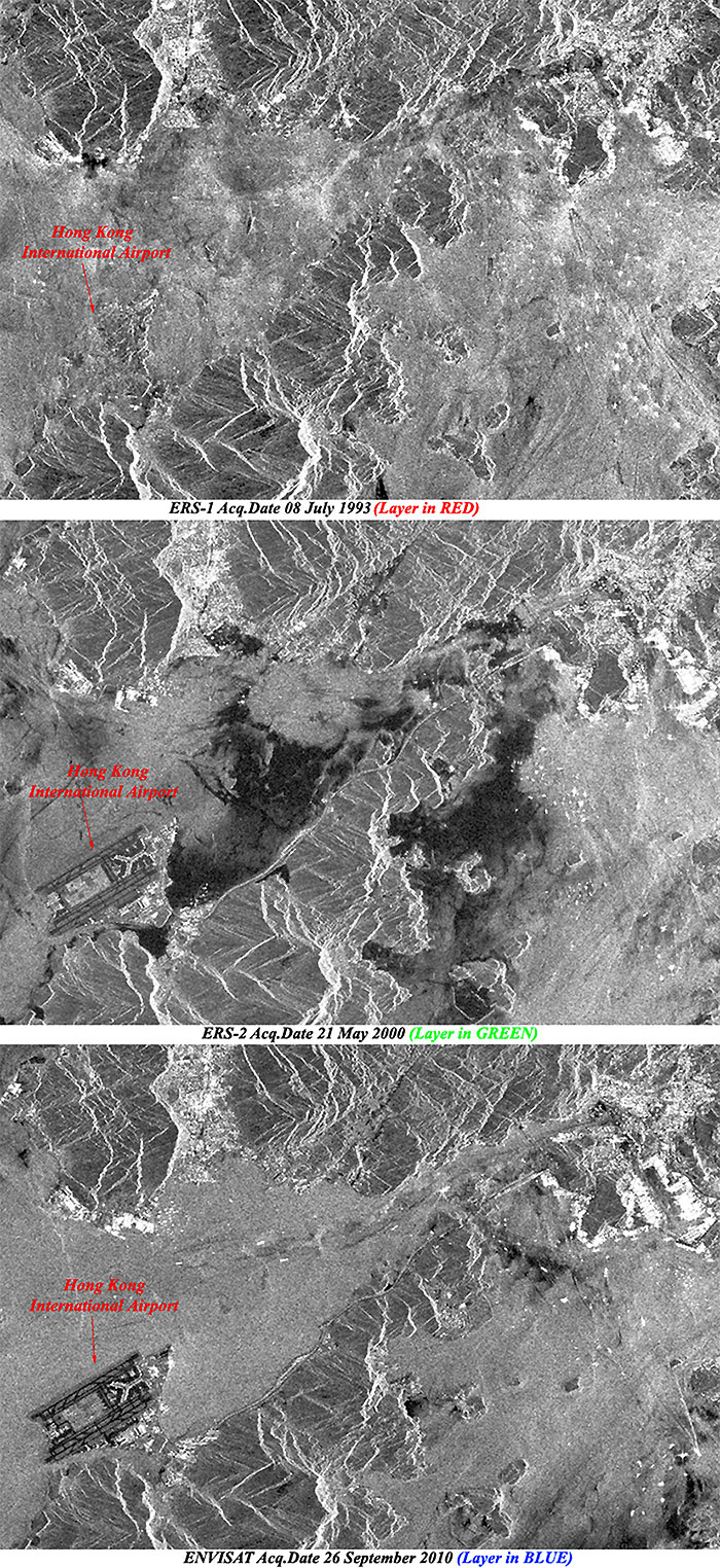
The full resolution images taken by ERS and Envisat, show the details of the area using different images acquired during these missions. The animation shows the phases of the different levels of airport construction starting from July 1993 to September 2010.
|
Images used to create the animation |
|
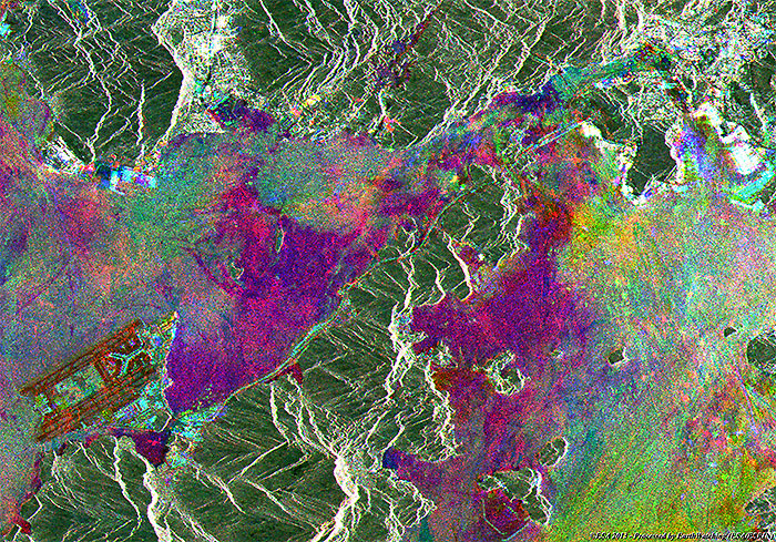
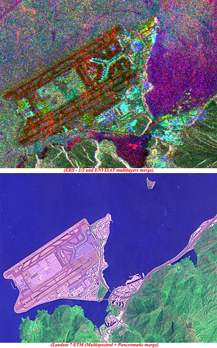
ASAR_IMP multi-layer image of the area |
This multi-layer image is a merge between different images from the ERS-1/2 and Envisat satellites utilising the SAR/ASAR instruments. The image shows the different acquisitions in green (ERS-2 - acquired May 2000) and blue (Envisat - acquired September 2010).
|
Technical Information |
|
Satellite: |
ERS-1/2 and Envisat |
|
Instrument: |
Synthetic Aperture Radar (SAR) / (ASAR) (30 metre resolution) |
|
Product: |
ASA_ASAR (level 1b full resolution) |
|
Date of acquisition: |
25 Aug 2010, 18 Aug 1999, 04 Oct 1992 |
|
Coverage: |
100 km along track |
|
Band combination: |
Merge layer ENVI - ERS1/2 (R-G-B) |
|
Magnified view of the airport |
|
Images used to create the multi-colour merge |
|
Landsat 5 and 7 animation from May 1988 to September 2000 |
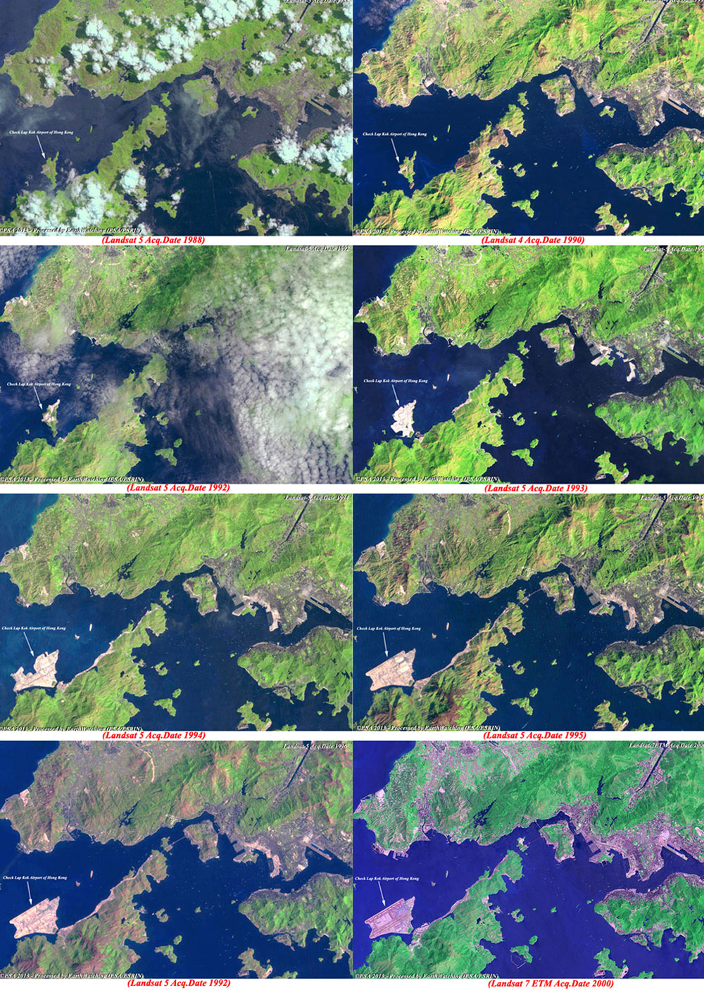
This animation created from a series of images acquired with the Landsat 5 and 7 satellites, shows the phases of construction relative to the new airport. Starting from 1988 the animation shows the two islands where the infrastructure was realised. In 1990 the island of Chek Lap Kok is visible as the first changes for the construction of the airport. From 1992 to 2000 the images show the state of work on the island.
|
Images used to create the animation |
|
Technical Information |
|
Satellite: |
Landsat 5 and 7 |
|
Instrument: |
TM (30 metre resolution) |
|
Product: |
TM/ETM (full resolution) |
|
Date of acquisition: |
May 1988 to Sep 2000 |
|
Coverage: |
185 km x 185 km |
|
Band combination: |
7, 4, 2 (R-G-B) |
This image taken from Landsat 7, is a merge between multi-spectral (30 metre) and panchromatic (15 metre) bands. The image shows the large area where the new Hong Kong Airport is built along with the infrastructures constructed along the coast to make for an easier connection to the city.
|
Technical Information |
|
Satellite: |
Landsat 7 |
|
Instrument: |
ETM (30 and 15 metre resolution) |
|
Product: |
ETM (full resolution) |
|
Date of acquisition: |
14 Sep 2000 |
|
Coverage: |
185 km x 185 km |
|
Band combination: |
7, 4, 2 (R-G-B) |
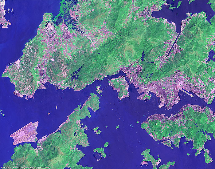
The Hong Kong International Airport occupies a 12.48 square km site on an artificial island built from two smaller islands and reclaimed land. It's the second busiest airport in terms of cargo traffic and the world's 13th busiest in passenger traffic.
Back to top
 Browse SAR Events by Year