- All Categories (31)
- News (10)
- Missions (2)
- Events (4)
- Tools (2)
- Activities (2)
- Documents (11)
News - Infographics
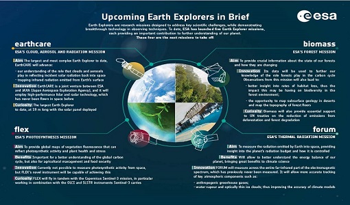
What are the next Earth Explorers?
Four more missions are currently planned - EarthCARE, Biomass, FLEX, and FORUM - which will further our understanding of
Event - Meeting
VH-RODA and CEOS SAR workshop
The workshop provided an open forum for the presentation and discussion of current status and future developments related
News - Thematic area articles
Tracking the world’s forests from space
Deforestation in Brazil Scientist’s understanding of the health of the world’s forests is being further improved through current
Mission - Third Party Missions
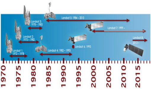
Thematic Mapper (TM) Processor Releases
GCP displacement B TM radiometric calibration Update to radiometric calibration strategy for TM reflective bands (Dark Current
Document - Technical Note
Technical Note on Quality Assessment for Landsat 1-7
Technical Note on Quality Assessment for Landsat 1-7
News - Thematic area articles
Space helps monitor Earth’s changing biosphere
Ocean chlorophyll concentrations can change when ocean currents shift, or sea temperature rises - all impacts of climate
News - Thematic area articles
Space data support Earth’s ecosystems
Currently, it is not possible to measure photosynthetic activity from space, but the forthcoming FLuorescence EXplorer (FLEX
Event - Workshop
Space and the Arctic 2009 Workshop
possibilities for the future : Volker Liebig, Director of ESA EO Programme Observations of the Arctic - EUMETSAT's Contribution to Current
Activity - Quality
SLAP
Currently, in excess of 701,000 Level 1 TM and 84,000 Level 1 ETM+ products have been reprocessed and released under the
News - Thematic area articles
Satellite data central to ocean monitoring
microwave monitoring instruments, optical imagers, and infrared radiometers, which can map ocean variables related to ocean currents
Document - General Reference
PolInSAR-2013-session-summaries-recommendations.pdf
This document provides the session summaries and recommendations from the PolInSAR 2013 workshop.
Event - Workshop
POLinSAR 2013
Snow, Land Ice and Sea Ice Monitoring Hazards: Fire Monitoring, Volcanoes, Flooding, Earthquake Other applications Past, current
Mission - Third Party Missions
Multi Spectral Scanner (MSS) Processor Releases
GCP displacement B TM radiometric calibration Update to radiometric calibration strategy for TM reflective bands (Dark Current
Document - Product Document
LANDSAT_Products_Description_Document.pdf
This document acts as a User Guide to the Landsat MSS, TM and ETM+ archives, focussing more specifically on the Landsat TM and ETM+ products from the Kiruna, Maspalomas and Matera archives (including from the Matera, Fucino, Neustralitz, O’Higgins, Malindi, Libreville and Bishkek ground stations) that have been generated as part of the ESA archive bulk-reprocessing project.
News - Thematic area articles
How space data are transforming the global food system
ICEYE, for example, is a constellation currently consisting of 11 X-band Synthetic Aperture Radar satellites – with seven
News - Thematic area articles
How satellite data help to shape society
Title: Current drought situation in Ebro basin Description: The SMOS soil-moisture-based drought monitor is updated monthly
News - Thematic area articles
How satellite data empower sustainable urban growth
Some 56% of the world's population currently reside in cities and the number of urban inhabitants is expected to double by
Document - General Reference
Heritage Missions brochure
This brochure describes ESA's Heritage Space Programme and includes infographics describing some of the missions in the programme.
News - Success Stories
Heritage data trains neural networks to detect urban sprawl
Since they’ve been trained identically, they can help monitor both current and past urban changes.
