- Learn & Discover
- Space helps monitor Earth's ch...
Space helps monitor Earth’s changing biosphere
21 Jul 2022
Earth is a living planet. Living organisms on Earth’s surface interact with the hydrosphere, atmosphere, cryosphere and lithosphere, together forming Earth’s biosphere – a zone of life.
Earth’s biosphere is continually changing. Through its pioneering Earth observation missions, ESA is making critical contributions to monitor these changes and their impacts on Earth’s water and carbon cycles.
Satellites provide consistent measurements of both natural changes (e.g. fires, insect plagues) and anthropogenic disturbances (e.g. deforestation, urbanisation). Time series satellite data provide ways to better understand Earth’s biosphere, and aid efforts to leverage biosphere processes as carbon sinks.
Ultimately, all life on Earth depends on water and green plants. Tracking changes in Earth’s vegetation, in the form of chlorophyll or biomass, is the aim of several of ESA’s remote sensing missions. For scientific purposes, ESA enable free access to this remote sensing data.
Biomass, ESA’s next Earth Explorer mission, will measure global forest carbon to help us understand the role of forests in the carbon cycle.
What are the 3 parts of the biosphere?
The biosphere refers to the zone of Earth containing life. It is made of three parts - lithosphere, atmosphere and hydrosphere. The biosphere refers only to regions where life is sustained, such as the lower atmosphere where birds can fly. While Earth’s lower mantle and core are part of the lithosphere, they do not contain life and are not part of the biosphere.
Radar penetrates dense forests
Sensitivity to the entire vertical forest structure will be achieved using a P-band synthetic aperture radar (SAR) instrument with a 435 MHz frequency and 6 MHz bandwidth. P-band is less common in space borne SAR systems, but can penetrate the vegetation layer, even in a dense tropical forest.
By monitoring where forest biomass is changing, the mission will for example estimate the deforestation flux and the emission of greenhouse gases from forest ecosystems.
Another Earth Explorer, the FLEX mission, will provide information about photosynthetic activity, to shed light on the functioning of Earth’s vegetation.
The mission aims to predict future trends in the global carbon cycle, by using plant fluorescence to monitor light absorption in vegetation and then translate this information into carbon assimilation data.
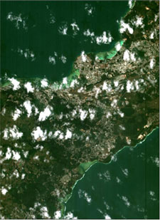
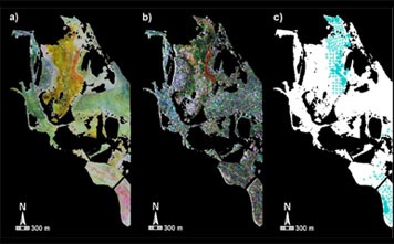
Mapping chlorophyll on land and water
The Compact High Resolution Imaging Spectrometer (CHRIS) onboard the agile PROBA-1 satellite provides atmospheric, land, agricultural and oceanic observations. CHRIS provides data on leaf area index (LAI) and chlorophyll, which is relevant for monitoring stress in forests.
CHRIS also provides high spatial resolution and multi-temporal 'ocean colour' imagery. Ocean chlorophyll concentrations can change when ocean currents shift, or sea temperature rises - all impacts of climate change.
As scientists accelerate their efforts to understand how we can combat global warming, it is important to examine long term changes in vegetation. Absorbing carbon through photosynthesis can help mitigate the excessive release of carbon as humans continue to burn fossil fuels.
Why is land important to biosphere?
The terrestrial biosphere - the region of Earth’s land surface containing life – provides shelter and food so that a huge variety of plants and organisms can thrive. Through the process of photosynthesis, plants store carbon, thus influencing the carbon dioxide concentration in the atmosphere. Vegetation at the land surface controls how solar radiation returns to the atmosphere.
Understanding interannual changes in vegetation conditions is possible with the Normalised Difference Vegetation Index (NDVI) product, which can be derived from a variety of sensors on many of ESA’s operational and non-operational missions.
Heritage data support land cover mapping
An example of this is the Advanced Very High Resolution Radiometer (AVHRR) sensor, first used onboard NOAA satellites starting 1981. As part of ESA’s Heritage Space Programme, AVHRR data are accessible free-of-charge for their entire 40-year lifetime.
Other non-operational heritage missions provide valuable data on our Biosphere. The many instruments on the ERS satellites, and its successor Envisat, provide measurements on sea and ice surfaces and atmospheric water content.
Optical imagery from the SPOT (Satellite pour l’Observation de la Terre) series has been utilised to achieve progress in science related to vegetation monitoring, agriculture, forestry, soils and urban planning.
ESA is also offering scientists free access to QuickBird-2 data archives, a mission whose global collection of panchromatic and multispectral imagery supports map creation and change detection in remote land types.
Similarly, the Japanese environmental JERS-1 satellite, which ceased operations in 1998, provides data on global land masses for land surveys, agriculture, forestry and fisheries.
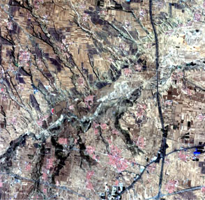
Rapid changes in vegetation
Commercial third party Earth observation satellites play a key role in monitoring our biosphere. Available as part of ESA’s Third Party Mission Programme (TPM), the WorldView satellites provide highly detailed imagery, designed to improve classification of land and aquatic features. Earth features can be geolocated to less than 5 m to create maps in remote areas.
Pléiades Neo has recently joined ESA’s TPM programme and provides continuity for the Pléiades mission, with enhanced performance in terms of accuracy, reactivity and frequency. Pléiades Neo plays an important role in monitoring vegetation thanks to its 30 cm resolution combined with the availability of the Red Edge band.
Detailed vegetation mapping and monitoring of rapid changes in vegetation and land use, is one of the strengths of Planet’s data, now also available free-of-charge for research purposes via ESA’s TPM programme.
Another TPM, RapidEye, was the first commercial satellite constellation to include the Red-Edge band, which is sensitive to changes in chlorophyll content.
In the wake of the United Nations climate change conference – COP26 – we have reached a pivotal junction in global climate action. Carbon dioxide build-up in our atmosphere is the primary cause of global warming.
Earth’s biosphere can help absorb this excess carbon, which is why monitoring life in our biosphere, be it on land or water, and understanding its function in climate action is more critical than ever.