- Learn & Discover
- Satellite data central to ocea...
Satellite data central to ocean monitoring
31 Mar 2022
Over 95% of Earth’s water is found in our oceans, and yet sadly, oceans are under stress from climate change and pollution. Monitoring our oceans is vital for Earth’s survival and satellites are the primary means of long-term and independent observation of our vast ocean bodies and their associated coastal zones.
As part of our Earth Online series on Thematic Areas, this article showcases the numerous ESA missions providing essential data to help keep watch on and protect our oceans.
How are satellites used in oceanography?
Satellites provide a variety of benefits for monitoring the oceans, with instruments able to measure depth (bathymetry), ocean colour and circulation, sea ice, sea surface height and temperature, and weather monitoring among many other applications. Satellites are essential in supporting these types of measurements as their high perspective offers an overview of the oceans that cannot be obtained from sea-borne vessels.
Both active and non-operational Earth observation satellites are equipped with various microwave monitoring instruments, optical imagers, and infrared radiometers, which can map ocean variables related to ocean currents, sea ice and sea surface.
The data acquired by these many missions also support maritime security and marine environmental monitoring and are a vital tool for tracking climate change.
Using pioneering space technologies, the Earth Explorer family of research missions have long provided crucial ocean data. The first Earth Explorer, the Gravity Field and Steady-State Ocean Circulation Explorer (GOCE), used a state-of-the-art gradiometer to open a window into the currents circulating within the depths of oceans.
Although GOCE is no longer operational, its data are provided through ESA’s Heritage Space Program and continue to improve our understanding of ocean circulation, heat transport by ocean currents, as well as ice-sheet surface topography from altimetry.
Earth Explorers boost climate research
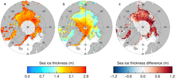
Sea ice is formed from freezing ocean water and the behaviour of polar sea ice has a significant impact on global climate change. The CryoSat mission uses advanced synthetic aperture radar and interferometry techniques, to accurately monitor sea ice in polar regions.
The Soil Moisture and Ocean Salinity (SMOS) mission contributes to climate research by mapping ocean salinity—a key variable used in oceanographic and climate change models. Meanwhile, one of the lesser-known applications of ESA's three-satellite Swarm mission, which measures Earth’s magnetic field, is identifying ocean circulation using its magnetic signature.
New possibilities with Third Party Missions
Through the Earthnet programme ESA facilitates data access from a plethora of Third Party Missions (TPM) many of which provide high resolution images, opening various possibilities for ocean water monitoring and maritime surveillance. For example, the spectral bands in mode 2 of the Compact High Resolution Imaging Spectrometer (CHRIS) onboard the PROBA-1 satellite, are designed for ocean water quality monitoring.
CHRIS reveals bountiful biophysical and biochemical data, essential for protecting valuable ocean resources and habitats.
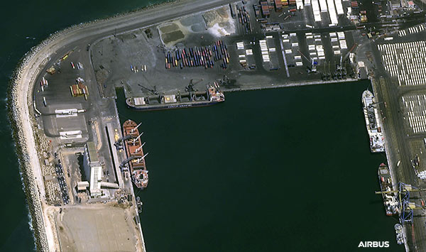
Pléiades and Pléiades Neo are TPMs providing a number of high-quality data products, which can be used extensively in marine security. Pléiades provides 50 cm resolution and Pléiades Neo provides 30 cm resolution. The Pléiades images are ideal for identifying maritime activities and navigation, oil spill monitoring and illegal fishing.
The maritime use-case applications of the ICEYE satellite constellation are plenty, ranging from vessel detection, wave height and wind estimation, to iceberg tracking.
The satellite data from another TPM, OceanSat-2, are applied to many ocean research areas, such as tornado trajectory prediction and coastal area mapping.
How long have satellites observed oceans?
Satellites have been used for oceanography for more than 40 years. Among the first dedicated oceanographic satellites was NASA’s SeaSat in 1978, data from which are still offered through ESA’s Third Party Missions programme. Since then, many other satellites have been launched by ESA and other agencies to gather information on our oceans.
Tracking ocean variables with Heritage Missions data series
There are also a multitude of examples where the long-term tracking of non-operational heritage missions facilitate ocean monitoring. Envisat data have been used by researchers to improve understanding of ocean systems using Doppler-based ocean surface velocity retrieval methods. There are future plans to optimise this method, so it can distinguish between ocean currents and waves.
ERS satellites also used a wind scatterometer to measure the direction and velocity of sea surface winds and a radar altimeter to accurately measure sea surface topography and elevation, as well as wave height. Tracking these variables over a long-time frame, can not only improve forecast accuracy, but also help us understand the impacts of anthropogenic greenhouse gases and global warming, since winds over the ocean help transfer heat, moisture and gases into and out of the ocean.
Ocean satellite data can contribute to protecting marine habitats, maritime safety and navigation, as well as supporting climate monitoring. Datasets from ESA’s satellites shed light on key ocean processes and activities –which, unfortunately, are alarmingly affected by the changes in our climate.