- All Categories (28)
- News (6)
- Missions (9)
- Events (7)
- Activities (4)
- Documents (2)
News - Thematic area articles

Transforming space data into climate action
By combining high-quality data from both current and previous missions, scientists are improving their understanding of the
News - Success Stories
Trailblazing ERS-2 mission enables climate change applications
Varied elevations of Bachu in western China InSAR is currently one of the most accurate methods to generate digital elevation
Event - Workshop

Space and the Arctic 2009 Workshop
possibilities for the future : Volker Liebig, Director of ESA EO Programme Observations of the Arctic - EUMETSAT's Contribution to Current
Activity - Quality
SLAP
Currently, in excess of 701,000 Level 1 TM and 84,000 Level 1 ETM+ products have been reprocessed and released under the
News - Infographics
Showcasing success stories from ESA's Heritage Missions
success stories showcased used data from ESA's ERS (European Remote Sensing) and Envisat satellites in combination with current
Activity - Quality
SEOM CAWA
The product validation and evolution of the algorithm are currently being performed.
Activity - Quality
SCIRoCCo
Author: The SCIRoCCo Team Abstract: The ERS Scatterometers in the Global Climate Observing System report describes the current
Mission - Heritage Missions

SAR (ERS) Processor Releases
It should be noted that for SAR, each product ordered is processed directly from the raw data, using the current version
Mission - Heritage Missions
SAR (ERS) Overview
Scientists are studying the radar backscatter from the ocean surface related to wind and current fronts, to eddies and to
Mission - Heritage Missions
SAR (ERS) Interferometry
addition, components of the interferometric signal such as anomalous signal path lengths introduced by atmospheric effects are currently
Mission - Heritage Missions
SAR (ERS)
Processor Releases It should be noted that for SAR, each product ordered is processed directly from the raw data, using the current
Mission - Third Party Missions

Multi Spectral Scanner (MSS) Processor Releases
GCP displacement B TM radiometric calibration Update to radiometric calibration strategy for TM reflective bands (Dark Current
News - Thematic area articles

How satellite data help to shape society
Title: Current drought situation in Ebro basin Description: The SMOS soil-moisture-based drought monitor is updated monthly
News - Success Stories

Heritage data trains neural networks to detect urban sprawl
Since they’ve been trained identically, they can help monitor both current and past urban changes.
News - General News

ESA's improved Earth system data records: what is in store for the future?
The current focus is on spectral windows in the Ultraviolet-Visible-Near Infrared regions for the retrieval of atmospheric
Document - Product Document

ERS-1-WSC-FDC-Product-CCT-Format.pdf
This document deals with the Product Specifications for the WSC Fast delivery copy. Valid for data processed up until end of July '95 when there was a switch in format from CEOS to CCSDS.
Mission - Heritage Missions

ERS Radar Course 3
Therefore, microwaves easily penetrate clouds, and images can be acquired independently of the current weather conditions
Mission - Heritage Missions
ERS Radar Course 2
Therefore, microwaves easily penetrate clouds, and images can be acquired independently of the current weather conditions
Mission - Heritage Missions
ERS Radar Course 1
Therefore, microwaves easily penetrate clouds, and images can be acquired independently of the current weather conditions
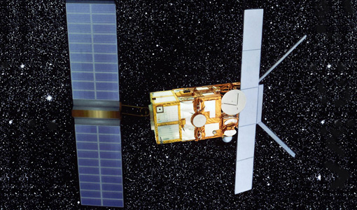
Mission - Heritage Missions

ERS Overview
global scale, the two ERS satellites expanded our understanding of the interaction between the oceans and atmosphere, ocean currents