- All Categories (863)
- Data (3)
- News (21)
- Missions (1)
- Events (4)
- Tools (2)
- Campaigns (1)
- Documents (831)
NEWS
Discover the latest news on the European Space Agency's Earth Observation activities. Learn all about new data availability and how ESA's missions are performing.
News - Thematic area articles
 30 June 2022
Transforming space data into climate action
ESA’s Earth observation activities are playing a key role in the revitalised global drive to combat climate change.
News - General News
 17 July 2023
SMOS Tools updates
Updates for two SMOS tools have been released, offering new features and improvements.
News - Data Release news
 18 Nov 2021
SMOS sea ice thickness Arctic winter season 2021/2022 data available
SMOS Sea Ice thickness level 3 and level 4 data products are now available for the Arctic winter season 2021/2022.
News - Data Release news
28 May 2021SMOS level 1 and level 2 products new baseline is now available
New versions of the SMOS processors for level 1 and 2 were deployed in the operational ground segment on 25 May 2021.
News - Data Release news
 24 Mar 2022
SMOS L2 Sea Surface Salinity products documentation updates
SMOS L2 Sea Surface Salinity product validation report is now available.
News - Success Stories
24 May 2023SMOS data reveal ecosystems' resistance to drought
Climate change is rapidly altering the world’s ecosystems, causing extreme weather conditions, such as droughts, to become increasingly frequent. Understanding the factors that contribute to ecosystem resilience to extreme events is vital to develop more effective strategies for climate adaptation and mitigation.
News - Thematic area articles
 16 Aug 2022
Satellites reveal changes to Earth’s icy zones
ESA’s Earth observation activities are helping scientists investigate the influence of climate change on widespread ice-losses across the planet.
News - Thematic area articles
 2 Nov 2022
Satellites investigate Earth’s terrestrial hydrosphere
ESA’s Earth observation satellites are playing a leading role in furthering our understanding of how Earth’s water cycle is being influenced by humankind.
News - Thematic area articles
 31 Mar 2022
Satellite data central to ocean monitoring
Over 95% of Earth’s water is found in our oceans, and yet sadly, oceans are under stress from climate change and pollution. Monitoring our oceans is vital for Earth’s survival and satellites are the primary means of long-term and independent observation of our vast ocean bodies and their associated coastal zones.
News - Thematic area articles
 2 Feb 2022
Satellite data boost global understanding of land surface
Understanding our changing land surface is essential in the study of climate change. Satellites are used to monitor changes to the material that covers Earth’s surface, so-called land cover, such as vegetation and water.
News - General News
 27 Mar 2023
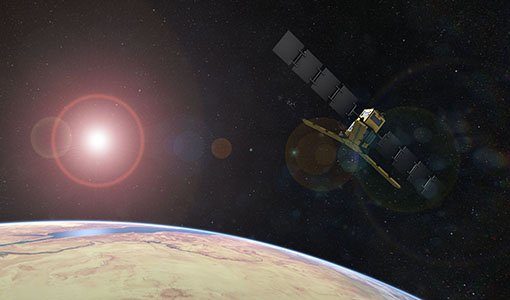
Overachieving SMOS mission primed for continued success
ESA’s Soil Moisture and Ocean Salinity mission (SMOS) was the second Earth Explorer launched in 2009. Over 13 years on, having already vastly exceeded its predicted lifetime and initial objectives, the mission has been further extended until at least the end of 2025.
News - Data Release news
30 Jan 2023New version of the SMOS-CryoSat level 4 sea ice thickness product is now available
The new version 205 of the merged SMOS-CryoSat level 4 sea ice thickness product is now available on the SMOS dissemination service
News - Data Release news
19 Feb 2024New reanalysis dataset impacts SMOS Level 3 and 4 sea ice thickness
On 24 January 2024 the JRA55 reanalysis dataset was terminated and updated with the Japanese Reanalysis for Three Quarters of a Century.
News - Success Stories
 14 May 2019
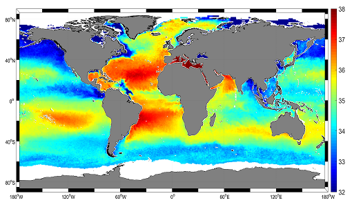
Mapping salty waters
The length and precision with which climate scientists can track the salinity, or saltiness, of the oceans is set to improve dramatically.
News - Infographics
 4 May 2023
Key facts about SMOS Level-1 and Level-2 science data
Learn about data products from the SMOS mission in our latest infographic.
News - Events and Proceedings
17 Jan 2024Highlighting the value of SMOS data in space weather applications
Data from ESA’s SMOS mission are driving many space weather applications, ranging from air navigation, characterisation of solar flares, space weather modelling and ionospheric electron content mapping.
News - Thematic area articles
9 Dec 2022Global understanding of Earth's land surfaces greatly boosted by satellite data
ESA perform land surface monitoring with a range of instruments onboard satellites acquiring optical and radar data. Collections of data from these missions are freely available for research purposes.
News - General News
21 Mar 2023ESA's excellent Earth Explorer missions extended to 2025
Since 2009, ESA’s Earth Explorer missions have pioneered breakthrough technologies and transformed our understanding of Earth’s system, from its core to the outer stretches of the atmosphere.
News - Events and Proceedings
14 Dec 2022ESA invites scientists to submit abstracts for EGU 2023
ESA is calling for researchers to submit abstracts for sessions at the next General Assembly of the European Geosciences Union (EGU 2023).
News - Data Release news
 16 May 2018
Eight years of SMOS Arctic sea ice thickness level now available from SMOS Data dissemination portal
Daily maps of sea ice thickness based on SMOS Observations, covering the winter seasons in the Arctic for the period of October-April from year 2010/2011 to year 2017/2018, are now available.