- News & Events
- ESA's excellent Earth Explorer...
ESA's excellent Earth Explorer missions extended to 2025
21 Mar 2023
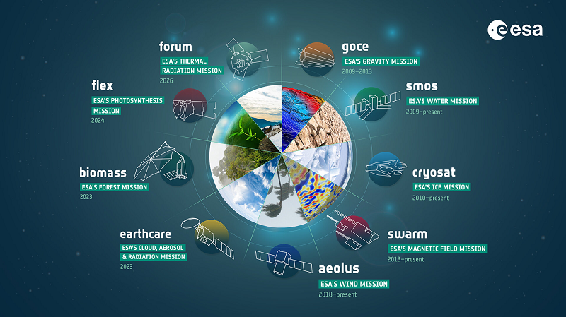
Since 2009, ESA’s Earth Explorer missions have pioneered breakthrough technologies and transformed our understanding of Earth’s system, from its core to the outer stretches of the atmosphere.
Though the first Earth Explorer, GOCE, was retired in 2013, ESA’s second, third and fourth - SMOS, CryoSat and Swarm - continue to soar. Each mission has been extended at least until the end of 2025.
Trailblazers when they were launched and cutting edge still to this day, ESA’s water, ice and magnetic field missions have seeded European competence in science and technology and set new paradigms for Earth Observation. Mission data are routinely used in operational services such as weather forecasting, and form key datasets informing all major climate reports.
Their successes have paved the way for critical operational missions, such as Copernicus Imaging Microwave Radiometer (CIMR) and Copernicus Polar Ice and Snow Topography Altimeter (CRISTAL).
In line with their goal of advancing Earth science, new scientific objectives ensure each Earth Explorer continues to refine and redefine how we monitor the pulse of our planet from space.
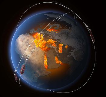
SMOS
ESA’s Soil Moisture and Ocean Salinity mission (SMOS) was the second Earth Explorer to be launched in 2009. Its novel microwave imaging radiometer (MIRAS) picks up faint microwave emissions from Earth’s surface and remains the only one of its kind in orbit. MIRAS primarily measures soil moisture, which is important for tracking droughts and flood risk, and sea surface salinity.
In its 13+ years in orbit SMOS has expanded its product portfolio to include sea ice thickness, soil freeze/thaw, and ocean extreme winds. All of these help to improve hydrological, oceanographic and atmospheric models. The mission continues to find new uses as varied as forest degradation, disease and pest monitoring, and space weather.
SMOS data are now used operationally by organisations such as ECMWF and hurricane forecasting centres worldwide, and are part of ESA’s Climate Change Initiative’s (CCI) Essential Climate Variables and Copernicus Climate Change Service (C3S). In the next extension phase, the mission’s ever-growing datasets will allow more in depth analyses of trends and climate extremes.
“Even after 13 years we see a steady increase in the number of users, and we’re constantly discovering new applications,” says SMOS Mission Manager, Klaus Scipal. “This extension ensures that continuous innovations directly feed back into the design of future Earth Observation systems such as Copernicus CIMR.”
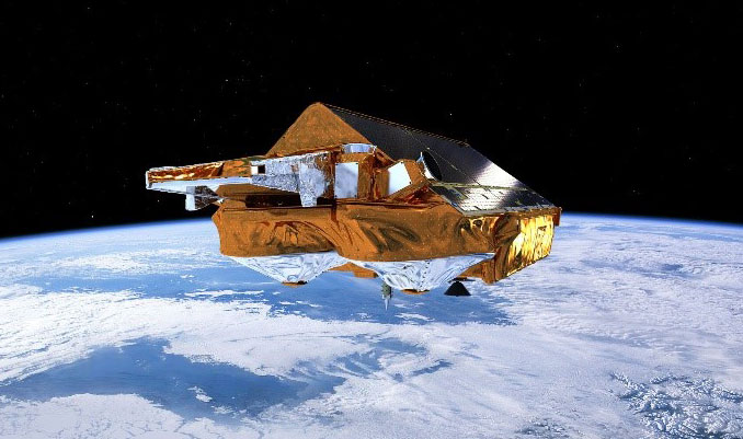
CryoSat
CryoSat launched in 2010, with the first spaceborne synthetic aperture interferometric radar altimeter (SIRAL). Designed to measure Earth’s polar land ice and sea ice, after more than 12 years in space ESA’s ice mission has far exceeded its initial objectives.
As the only radar altimeter providing measurements up to 88°, CryoSat is uniquely able to estimate sea levels at high latitudes. The mission set a new standard for how sea levels are estimated at the coast and has provided near-real time monitoring of polar oceans to aid shipping and other industries.
Further applications include improved mapping of the seafloor, better estimates of mountain glaciers using a novel swath processing technique, and measuring water height over rivers and lakes.
A major recent development has been a unique collaboration with NASA to align CryoSat’s orbit with that of ICESat-2. Coincident measurements over the poles combine radar and lidar altimetry to better estimate snow depth on ice. Known as CRYO2ICE, the collaboration is a key component of the next extension period and will provide vital information for the future CRISTAL mission set to launch in 2027.
“CryoSat has provided the longest ever continuous satellite record of our rapidly changing cryosphere,” says CryoSat Mission Manager, Tommaso Parrinello. “It’s critical for the maintenance of our long term records of global ice that the CryoSat mission can continue as long as possible until CRISTAL can take the baton.”
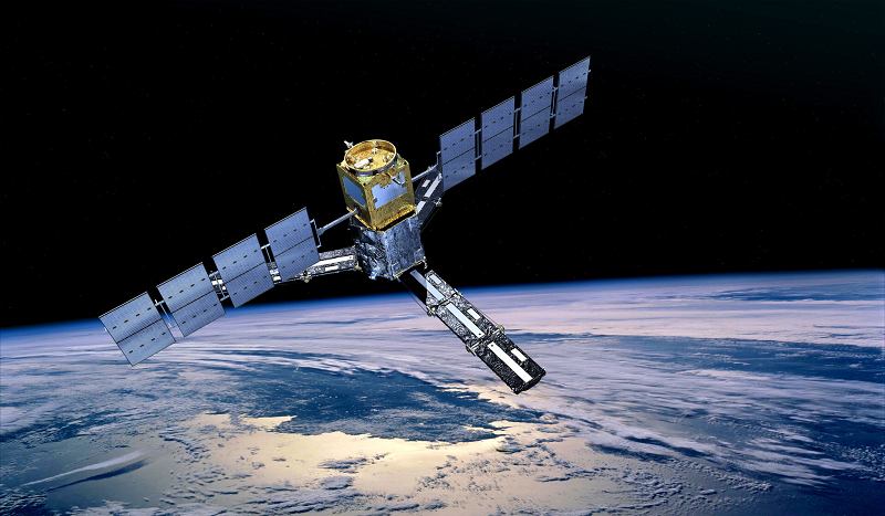
Swarm
Swarm mission, this year its tenth in orbit, is ESA’s first ever Earth Observation constellation. The identical trio consists of a pair of lower orbiting satellites Alpha and Charlie, with third sibling Bravo above. Each satellite carries a vector field magnetometer (VFM) as its primary instrument, providing highly precise measurements of the strength and direction of Earth’s magnetic field and its evolution over time.
“The best aspect of the Swarm mission is its huge diversity of applications,” says Swarm Mission Manager, Anja Strømme. “We are answering fundamental questions about Earth’s magnetic field, improving our understanding of processes from the Earth’s core all the way out to the solar wind.”
The unprecedented high resolution data offered by Swarm has enabled scientists to understand phenomena such as the South Atlantic Anomaly - a significant recent weakening of Earth’s magnetic field - in greater detail than ever before.
At the core, Swarm mission data have revealed a completely new type of magnetic wave. Moving closer to the surface, geologists have used it to piece together Antarctica’s tectonic past. Heading into the outer reaches of Earth’s atmosphere, diverse discoveries include ionospheric thunderstorms that cause satellite GPS to black out, supersonic plasma jets, and a new type of auroral feature known as Steve.
In the extension period, Swarm will continue its pioneering role in space by becoming the first ever mission to migrate to ESA’s new Ground Operation System Common Core - ushering in the next generation of space systems monitoring and control.
Synergy in space
The Earth Explorers are not just innovators in their own sphere. They are orbiting laboratories that nurture synergies in space, with primary and secondary instruments providing data that complement and enhance those of other missions.
CryoSat’s magnetometer, for example, provides such good data that a fully calibrated and processed product called CryoMAGNET is now used by scientists of the Swarm mission community.
Another example is the combination of SMOS and CryoSat sea ice thickness data into one product, making best use of both sensors and optimising their respective errors. In addition to operational applications such as ship route forecasting, thin sea ice thickness data - still a big challenge in cryosphere research - aid the climate modelling community.
“As more Earth Explorers are set to launch in the coming years and with extensions to the current crop there will be further opportunities to forge synergies in space, many that are as yet unpredicted,” says Head of the Earth Observation Mission Management Division, Henri Laur.
“It’s an exciting time for ESA and Earth Observation.”
This is the first article in a series that will celebrate the successes and explore the future objectives of the SMOS, CryoSat and Swarm missions as they continue their excellent data records through to 2025 and beyond.