- Learn & Discover
- Satellites investigate Earth’s...
Satellites investigate Earth’s terrestrial hydrosphere
02 Nov 2022
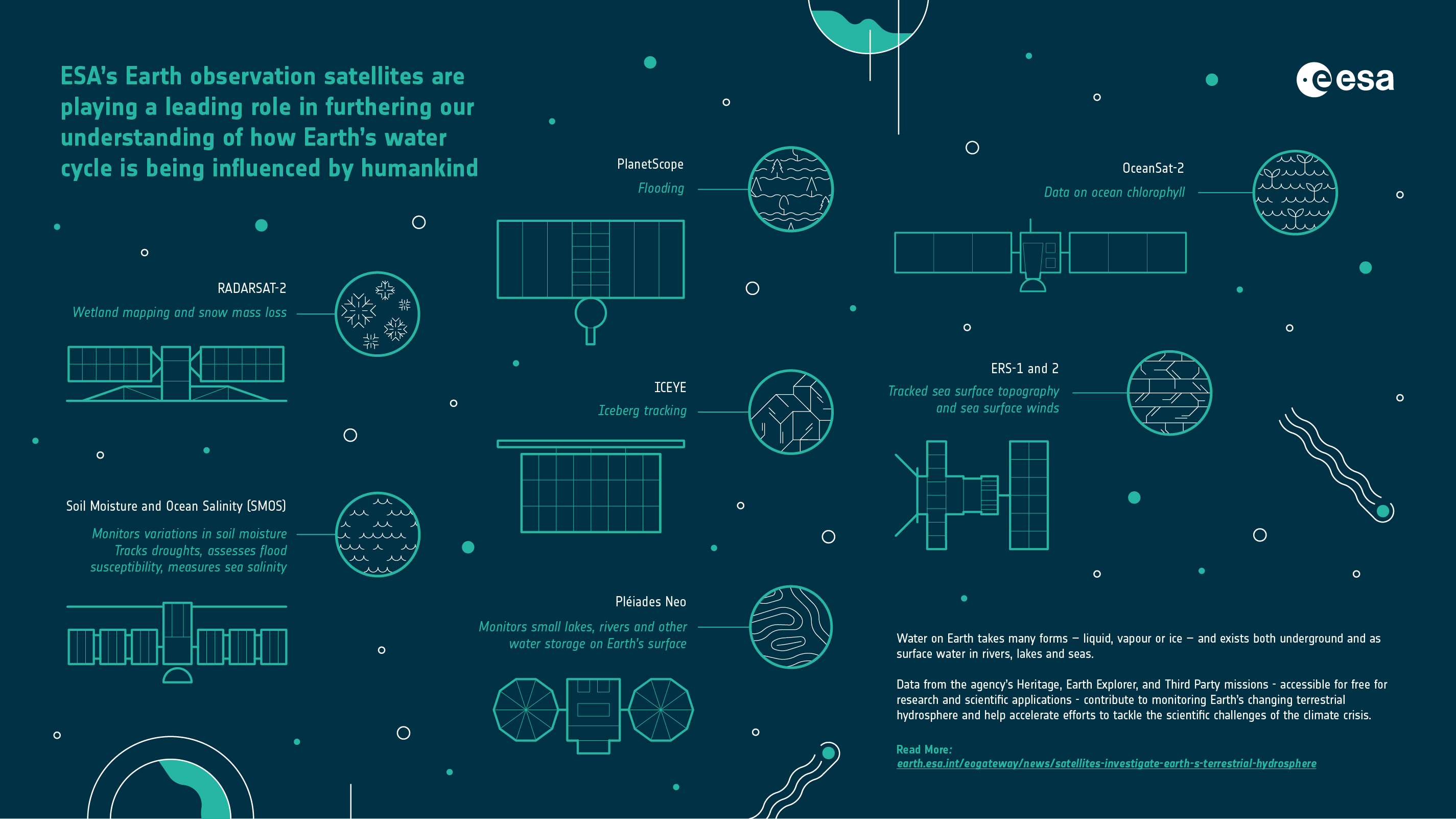
ESA’s Earth observation satellites are playing a leading role in furthering our understanding of how Earth’s water cycle is being influenced by humankind.
Water on Earth takes many forms – liquid, vapour or ice – and exists both underground and as surface water in rivers, lakes and seas.
Altogether, the total amount of water present on Earth’s surface and underground is known as the terrestrial hydrosphere.
Human activity directly impacts Earth’s water. Anthropogenic global warming influences extreme weather events such as flooding and drought, as well as coastal processes and sea level rise.
Where is most of the water in the terrestrial hydrosphere stored?
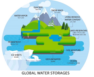
On Earth, liquid water exists in oceans, lakes, rivers, soil moisture, living biomass water content and groundwater. The frozen part of the hydrosphere includes ice sheets, permafrost, glaciers and snow mass. Of the world’s total water supply in the terrestrial hydrosphere, the most water is found in the ocean.
Wetland drainage and agricultural irrigation upset the natural balance of ecosystems, while fertilizers and sewage released into water storage areas cause water quality to deteriorate.
Data from the agency’s Heritage, Earth Explorer, and Third Party missions - accessible for free for research and scientific applications - contribute to monitoring Earth’s changing terrestrial hydrosphere and help accelerate efforts to tackle the scientific challenges of the climate crisis.
How can satellites be used to monitor the hydrosphere?
Satellites carry different types of instruments, which monitor the water in Earth’s hydrosphere. Scatterometers, radiometers, and altimeters measure a range of variables, such as precipitation, snow mass, glacial motion, sea ice extent, sea surface temperature, sea surface height, salinity and soil moisture. Optical sensors can detect changes in lakes, rivers and wetlands.
ESA’s dedicated water satellite
The Soil Moisture and Ocean Salinity (SMOS) mission completed its 13th year in orbit in November 2022. SMOS is one of ESA’s family of research missions – the Earth Explorers – and is ESA’s first mission dedicated to hydrology studies.
Soil moisture is a vital geophysical parameter for climate change studies. SMOS carries the microwave imaging radiometer with aperture synthesis (MIRAS) instrument, which monitors variations in soil moisture by tracking the microwave emissivity of soil.
SMOS images are used to derive global maps of soil moisture - at a spatial resolution of about 50 km – and aid understanding of hydrometeorological processes.
Soil moisture mapping has proven valuable for tracking droughts and in the framework of the European Flood Awareness System (EFAS), SMOS soil moisture products can be used to assess flood susceptibility.
Sea-surface salinity (SSS), or saltiness, plays an important role in density driven ocean circulation patterns and SMOS SSS products are vital for climate change models.
Measurement of sea salinity also have the potential to help understand important climate events, such as El Niño, and their feedback mechanisms.
What is the importance of the hydrosphere?
Water is a component of living cells and provides a habitat for a wide range of plants and animals, providing them with nutrients. Due to water’s high specific heat it contributes to heat regulation in Earth’s climate. The hydrosphere also fulfils many human needs – it provides drinking water as well as supporting agriculture, transportation, and hydropower.
Mapping ice thickness and movement
The solid form of Earth’s terrestrial hydrosphere is made of ice – glaciers, ice sheets, permafrost and icebergs – and is called the cryosphere.
CryoSat, another Earth Explorer, has the objective to deliver data on Earth’s frozen zones. Its data on ice thickness has contributed to research on the impact of climate change, revealing that Greenland and Antarctica are losing ice at unprecedented rates.
Part of ESA’s Third Party Mission Programme (TPM), RADARSAT-2 – Canada’s flagship mission for environmental monitoring – provides excellent capability for wetland mapping and has also been utilised for research on glacial motion and snow mass loss.
The ICEYE satellite constellation is useful for iceberg tracking, while very high resolution satellites such as Pléiades Neo provide the ability to monitor small lakes, rivers and other water storages on Earth’s surface.
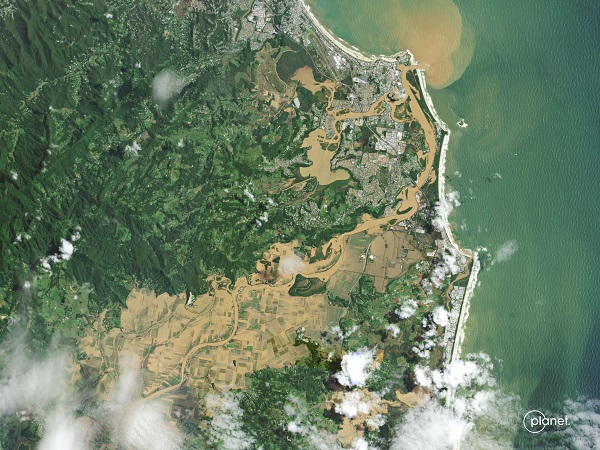
Recently, during the devastating flooding of the Kabul River in Pakistan, PlanetScope, another TPM mission, provided invaluable very high resolution images of the areas of interest.
Data show environmental impact
Tracking water quality with remote sensing data on ocean colour is useful for keeping watch on the aquaculture industry. OceanSat-2 data on ocean chlorophyll – accessible via the agency’s TPM programme – can help research into primary production estimation and the monitoring of phytoplankton blooms.
Understanding the long-lasting environmental impact of fish farming sites can be determined by comparing satellite-based water quality data from different periods, for example using long-time data series from the agency’s Heritage mission, Envisat, which delivered a decade of environmental data before it stopped operation in 2012.
Decadal assessment of ice sheet change is possible using data from the agency’s European Remote Sensing (ERS) programme - composed of two satellites, ERS-1 and ERS-2.
ERS satellites also tracked sea surface topography and sea surface winds, helping scientists understand how moisture transfers in and out of the ocean.
Since water plays such a fundamental role in Earth’s climate system, scientists strive to understand the pieces of our water cycle and how it is being impacted by humankind.
As our planet warms, monitoring water - using data from ESA’s diverse remote sensing missions – is more critical than ever.