- All Categories (86)
- Data (5)
- News (15)
- Missions (2)
- Events (10)
- Tools (5)
- Activities (1)
- Campaigns (1)
- Documents (47)
News - Thematic area articles
How to use space data to probe humankind’s ancient past
Data disseminated by ESA’s Third Party Missions (TPM) programme are enabling archaeological investigations that could help to unravel the mysteries of past societies and cultures.
News - Infographics
Discover how RADARSAT scans Earth's surface
Learn about how RADARSAT scans Earth's surface in our new infographic.
News - Thematic area articles
Monitoring water on Earth's surface
ESA's Earth observation satellites are playing a leading role in furthering our understanding of how Earth's terrestrial hydrosphere is being influenced by humankind.
News - Thematic area articles
Satellites investigate Earth’s terrestrial hydrosphere
ESA’s Earth observation satellites are playing a leading role in furthering our understanding of how Earth’s water cycle is being influenced by humankind.
Document - Data Access Information
ESA-archive-third-party-mission-collections.pdf
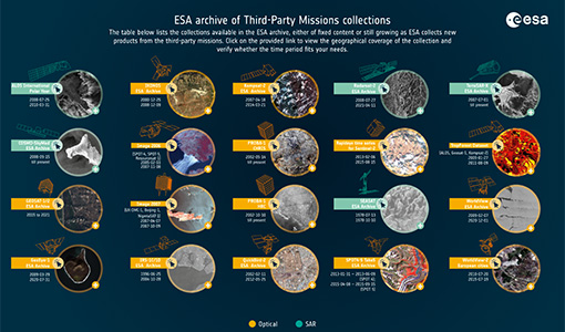
Discover the ESA archive data collections offered for the Third Party Missions programme.
News - Infographics
A summary of ESA Third Party Mission collections
A new summary is available, showcasing the ESA archives for Third Party Mission collections.
News - Thematic area articles
Space helps monitor Earth’s changing biosphere
Earth’s biosphere is continually changing. Through its pioneering Earth observation missions, ESA is making critical contributions to monitor these changes and their impacts on Earth’s water and carbon cycles.
Document - General Reference
Heritage Space Programme interactive brochure
Learn about ESA's Heritage Space Programme in this interactive brochure.
Document - General Reference
Heritage Missions brochure
This brochure describes ESA's Heritage Space Programme and includes infographics describing some of the missions in the programme.
Document - General Reference
Third Party Missions Brochure
This brochure summarises ESA's Third Party Missions programme, providing a timeline and examples of content related to some of the missions.
News - Success Stories
New open-source Python library improves rapid mapping services
In emergency services, rapid response is paramount. ICube-SERTIT’s Rapid Mapping Service provides near real-time delivery of geo-information to help emergency services respond quickly to disasters such as flooding, fires and landslides. A new Python open-source library, called EOReader, speeds up this mapping response by enabling the easy opening of imagery from multiple satellite sensors, both optical and synthetic aperture radar (SAR).
News - Data Release news
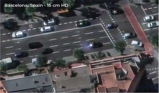
15 cm HD and 30 cm HD products added to EUSI ESA archive collections
Two new products, 15 cm HD and 30 cm HD, have been added to the collections from GeoEye-1, QuickBird-2, and WorldView (1 – 4).
News - Infographics
An overview of ESA's Third Party Missions programme
ESA’s Third Party Missions programme consists of almost 50 satellite missions, which are owned by organisations around the world. ESA has agreements with these organisations to acquire, process, and distribute data from their missions
News - Infographics
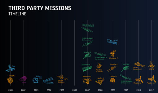
ESA Third Party Missions timeline
We've released a new timeline to illustrate the history of the ESA Third Party Missions.
News - Data Release news
EUSI ESA archive collections now open to users
In the Third Party Missions Programme framework, archive collections from GeoEye-1, QuickBird-2 and WorldView (1 to 4) have been opened to users.
Activity - General activities
GSCB and LTDP
The Copernicus programme is based on a fleet of European Earth observation satellites, built and operated by ESA, member states and commercial entities. Copernicus will also offer data from non-European satellites.
Data - Fast Registration with approval (Restrained)
QuickBird-2 ESA archive
The QuickBird-2 archive collection consists of QuickBird-2 products requested by ESA supported projects over their areas of interest around the world. The dataset regularly grows as ESA collects new products over the years. Panchromatic (up to 61 cm resolution) and 4-Bands (up to nominal value of 2.44 m resolution, reduced to 1.63 m when the orbit altitude was lowered to 300 km at the end of the mission) products are available. The 4-Bands includes various options such as Multispectral (separate channel for Blue, Green, Red, NIR1), Pan-sharpened (Blue, Green, Red, NIR1), Bundle (separate bands for PAN, Blue, Green, Red, NIR1), Natural Colour (pan-sharpened Blue, Green, Red), Coloured Infrared (pan-sharpened Green, Red, NIR1), Natural Colour / Coloured Infrared (3-Band pan-sharpened). The processing levels are: STANDARD (2A): normalised for topographic relief View Ready Standard (OR2A): ready for orthorectification View Ready Stereo: collected in-track for stereo viewing and manipulation Map-Ready (Ortho) 1:12,000 Orthorectified: additional processing unnecessary Map-Ready (Ortho) 1:15,000 Orthorectified: additional processing unnecessary Spatial coverage: Check the spatial coverage of the collection on a map available on the Third Party Missions Dissemination Service. The following table summarises the offered product types EO-SIP product type Band Combination Description BGI_PAN_2A Panchromatic (PAN) Panchromatic Standard/Panchromatic Ortho Ready Standard BGI_PAN_MP Panchromatic (PAN) Panchromatic Map Scale Ortho BGI_PAN_OR Panchromatic (PAN) Panchromatic Ortho Ready Stereo BGI_4B__2A 4-Band (4B) 4-Band Standard/4-band Ortho Ready Standard BGI_4B__MP 4-Band (4B) 4-Band Map Scale Ortho BGI_4B__OR 4-Band (4B) 4-Band Ortho Ready Stereo
Tools - Other
Geohazards TEP
The Geohazards Thematic Exploitation Platform (TEP) aims to provide Earth observation data for supporting geohazards applications.
Document - Proceedings
Fringe-2011-workshop-recommendations.pdf
This document contains the recommendations from the session summaries of the Fringe 2011 Workshop.
Document - Product Document
DigitalGlobe-Stereo-Imagery.pdf
Stereo Imagery products are designed for users with advanced image processing capabilities and photogrammetric tools.

