- All Categories (45)
- Data (5)
- News (19)
- Missions (2)
- Events (4)
- Tools (2)
- Activities (1)
- Documents (12)
News - Infographics

Timeline to over 40 years of historical satellite missions
ESA's Heritage Space Programme preserves historical data from over 40 years of Earth observation missions.
Document - General Reference

Third Party Missions Brochure
This brochure summarises ESA's Third Party Missions programme, providing a timeline and examples of content related to some of the missions.
Document - General Reference
The International Charter- Space and Major Disasters
The Charter is an important step forward in linking the needs of disaster and relief organisations with space technology solutions to help mitigate the effects of disaster on human life, property and the environment.
News - Success Stories

The Earthnet Programme: 40 years of evolution and future challenges
ESA's Earthnet Programme provided the initial means to access and exploit Earth Observation data.
News - Thematic area articles

Space data help to unravel the complexities of Earth’s atmosphere
As the impacts of the climate crisis intensify, scientists are using ESA’s Earth observation archives to investigate atmospheric processes and their influences on the planet’s changing environment.
News - Infographics
Showcasing the atmosphere-studying Odin mission
Learn about the Odin mission in our new infographic.
News - Success Stories

Satellites track the health of the ozone layer
ESA’s Earth observation activities are contributing to international efforts to monitor and preserve the layer of stratospheric ozone that blankets the planet.
News - Thematic area articles
Satellites expand research on Space Weather and Sun-Earth Interactions
Earth observation data provide vital warnings about the impact of solar activity and strive to unravel the influence the Sun has on Earth’s system.
News - Data Release news
Sample data products from ESA’s Third Party Missions
Samples of data products from a range of Third Party Missions are now available to download, offering a preview of what these missions provide.
Data - Project Proposal (Restrained)
ResourceSat-1/IRS-P6 full archive
ResourceSat-1 (also known as IRS-P6) archive products are available as below: Sensor Type Resolution (m) Coverage (km x km) System or radiometrically corrected Ortho corrected (DN) Neustralitz archive Global archive LISS-IV Mono-Chromatic 5 70 x 70 X X 2004 – 2010 2003 - 2013 LISS-III Multi-spectral 20 140 x 140 X X 2004 – 2013 2003 - 2013 AWiFS Multi-spectral 60 370 x 370 X X 2004 – 2013 2003 - 2013 Note: LISS-IV: Mono-Chromatic, the band is selectable. In practice the red is used. For LISS-IV MN and LISS-III ortho corrected: If unavailable, user has to supply ground control information and DEM in suitable quality. For AWiFS ortho corrected: service based on in house available ground control information and DEM. The products are available as part of the GAF Imagery products from the Indian missions: IRS-1C, IRS-1D, CartoSat-1 (IRS-P5), ResourceSat-1 (IRS-P6) and ResourceSat-2 (IRS-R2) missions. 'ResourceSat-1 archive' collection has worldwide coverage: for data acquired over Neustrelitz footprint, the users can browse the EOWEB GeoPortal catalogue to search archived products; worldwide data (out the Neustrelitz footprint) can be requested by contacting GAF user support to check the readiness since no catalogue is not available. All details about the data provision, data access conditions and quota assignment procedure are described in the Terms of Applicability.
Document - User Guide

ResourceSat-1-Data-User-Handbook.pdf
The IRS-P6 Data User’s Handbook is published to provide essential information to the users about the mission - the sensors, orbit and coverage, referencing scheme, data acquisition, products, services and potential applications of the data.
News - Thematic area articles
Remote sensing data map impacts of natural hazards
As climate change increases the frequency and severity of natural disasters, remote sensing data can warn about extreme events and help tackle emergency situations.
News - Data Release news
Release of Odin SMR reprocessed data
Data from the Odin Sub-Millimetre Radiometer (SMR) reprocessing has been released to users and is now freely available.
Document - General Reference
PREMIER-Report-for-Mission-Selection-An-Earth-Explorer-to-observe-atmospheric-composition.pdf
The objective of the PREMIER mission is to quantify the processes controlling global atmospheric composition in the mid/upper troposphere and lower stratosphere (5-25 km height range), which is a region of particular importance for climate change.
Activity - Quality
Odin-SMR
ESA/SPPA took the initiative to support the reprocessing of all Odin-SMR measurements in order to create a fully consistent and homogeneous dataset of stratospheric species profiles.
Document - Product Document

Odin-Level-2-Aeronomy-data-products.pdf
This document outlines the format and storage of the various data products from the Level 2 processing software for the Odin mission.
Data - Data Description
Odin SMR data products
The latest Odin Sub-Millimetre Radiometer (SMR) datasets have been generated by Chalmers University of Technology and Molflow within the Odin-SMR Recalibration and Harmonisation project, funded by the European Space Agency (ESA) to create a fully consistent and homogeneous dataset from the 20 years of satellite operations. The Odin satellite was launched in February 2001 as a joint undertaking between Sweden, Canada, France and Finland, and is part of the ESA Third Party Missions (TPM) programme since 2007. The complete Odin-SMR data archive was reprocessed applying a revised calibration scheme and upgraded algorithms. The Level 1b dataset is entirely reconsolidated, while Level 2 products are regenerated for the main mesospheric and stratospheric frequency modes (i.e., FM 01, 02, 08, 13, 14, 19, 21, 22, 24). The resulting dataset represents the first full-mission reprocessing campaign of the mission, which is still in operation.
Data - External Data (Restrained)
Odin OSIRIS data products
The Odin OSIRIS (Optical Spectrograph and Infra-Red Imaging System) data provides vertical profiles measures of spectrally dispersed, limb scattered sunlight from the upper troposphere into the lower mesosphere. The data products are regularly processed and provide Ozone density vertical profiles (both Level 2 and Level 3), vertical profiles of stratospheric Aerosol (both Level 2 and Level 3), slant column densities of nitrogen dioxide NO2 profiles (Level 2), stratospheric BrO profiles (Level 2).
News - Success Stories

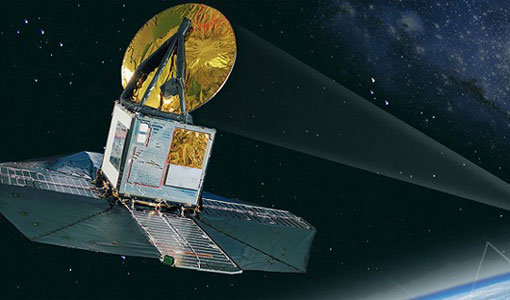
Odin celebrates 18 years in orbit
ESA is proud to celebrate the excellent long-lasting performance of the Swedish-led Odin mission.
Mission - Third Party Missions
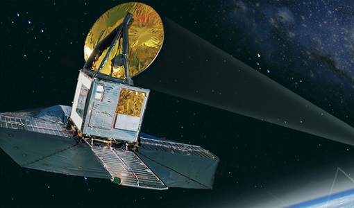
Odin
Odin is an atmosphere-studying satellite mission from Sweden, Canada, France and Finland.