- Learn & Discover
- Space data help to unravel the...
Space data help to unravel the complexities of Earth’s atmosphere
27 Apr 2022
As the impacts of the climate crisis intensify, scientists are using ESA’s Earth observation archives to investigate atmospheric processes and their influences on the planet’s changing environment.
These activities are facilitating numerous key applications, including modelling weather conditions, tracking greenhouse gas emissions and building improved projections of the climate.
Consisting of a blend of gases that envelops the planet, the atmosphere sustains life on Earth by protecting against heat and radiation emitted by the Sun and providing the air that people breathe.
Emissions from human activities are having substantial long-term impacts on this protective blanket – and, for decades, ESA has been helping the global community to track these changes, thanks to a succession of state-of-the-art remote sensing missions.
What is Earth’s atmosphere made of?
The atmosphere is composed of five layers, the troposphere, stratosphere, mesosphere, thermosphere and exosphere. Most satellites orbit in the highest layers; the thermosphere and exosphere, and atmospheric measurements acquired by satellites focus on the lowest layers; the troposphere and stratosphere.
Shaping understanding of the atmosphere
These include several non-operational Heritage Missions, such as ESA’s Envisat satellite, which launched in 2002 and delivered 10 years of data detailing different aspects of the environment.
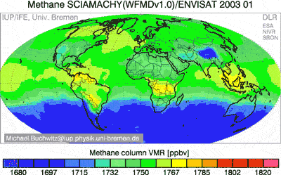
Envisat carried three instruments for monitoring the atmosphere, the Scanning Imaging Absorption Spectrometer for Atmospheric Cartography (SCIAMACHY), the Michelson Interferometer for Passive Atmospheric Sounding (MIPAS), and the Global Ozone Monitoring by Occultation of Stars (GOMOS) sensor.
Using SCIAMACHY, the cornerstone ESA Earth observation mission delivered unprecedented insight into the global distributions of methane and carbon dioxide, helping to underpin current understanding of these planet-warming gases.
In addition, MIPAS enabled Envisat to monitor the annually occurring Antarctic ozone hole, allowing scientists to track the long-term health of the ozone layer.
Through ESA’s Heritage Space Programme, Envisat data are maintained, made accessible, and continuously improved, so that these data can be combined with information from active missions to build continuous pictures of the environment.
International collaboration
Scientist’s understanding of planet-warming emissions is being further improved through current international remote sensing activities.
The Japanese GOSAT series, for instance, consists of two innovative satellites that are dedicated to monitoring carbon dioxide and methane.
The first GOSAT mission – which launched in 2009 and remains operational – hosts a greenhouse gas observation sensor and a cloud and aerosol sensor. In 2018, it was joined in orbit by GOSAT-2, which carries enhanced versions of its predecessor’s instruments.
In addition, the GHGSat constellation can monitor emissions from industrial facilities, revealing point sources as small as individual oil and gas wells. There are currently three GHGSat satellites in orbit, and there are plans to extend the constellation to up to 10 satellites dedicated to methane measurements by the end of 2023
The availability of GOSAT and GHGSat data is promoted through ESA’s Third Party Missions Programme, which fosters international collaborations to promote the delivery of accessible information about Earth’s environment.
Other atmosphere-monitoring missions covered by this programme include SciSat-1 and Odin.
Breakthrough space-borne technology
In addition to monitoring the composition of the air, ESA is using breakthrough space-borne technology to foster new insight into atmospheric processes.
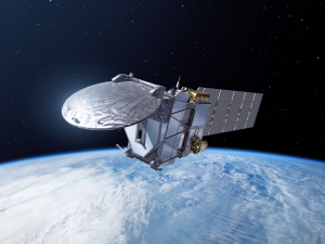
In 2018, the agency launched a pioneering satellite that uses laser technology to monitor the winds that sweep across the planet, paving the way for future doppler wind lidar missions.
The Aeolus mission – which is part of ESA’s Earth Explorers programme – carries one sensor called the Atmospheric Laser Doppler Instrument (ALADIN), which continues to operate in orbit.
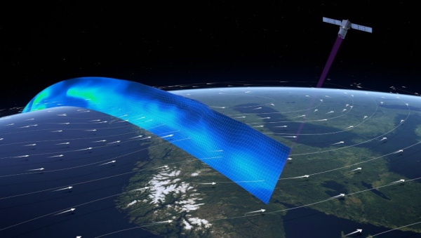
ALADIN fires short pulses of UV light towards the planet, which bounce off air molecules and other particles as they are blown through the atmosphere. The tiny fraction of light that scatters back towards the satellite is collected by a large telescope. By measuring the shift in frequency of the light that is scattered back to the satellite, Aeolus can determine the speed and direction of the wind in the lowermost 30 km of the atmosphere.
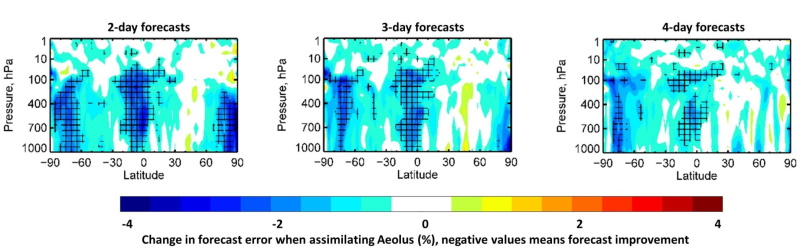
One of the most significant achievements of the mission is that meteorological centres now feed Aeolus data into their daily weather forecasting models, demonstrating the high quality of the satellite’s observations.
In addition, Aeolus data are being used to improve the accuracy of numerical weather predictions, advance understanding of atmosphere dynamics, and support climate-related research.
How far is the atmosphere from space?
The outmost layer of the atmosphere, the exosphere, extends to 10,000 km above Earth’s surface, but the edge of the atmosphere is generally regarded as being between 80 and 120 km. At this point, the atmosphere becomes so thin that spacecraft in Earth’s orbit experience little effect from aerodynamic forces.
Next Earth Explorers
Aeolus is one of several active Earth Explorers designed to investigate interactions between the planet’s systems – and the programme is set to expand in the coming years with a new mission called EarthCARE.
EarthCARE – the largest and most complex Earth Explorer to date – will use high-performance lidar and radar technology that has never been flown in space before.
Its objective is to deliver unprecedented datasets that will help scientists investigate the role that clouds and aerosols play in reflecting solar radiation back into space and trapping infrared radiation emitted from Earth's surface. This will support research into weather and climate change.