- All Categories (80)
- Data (15)
- News (20)
- Missions (4)
- Events (5)
- Tools (7)
- Activities (3)
- Campaigns (14)
- Documents (12)
Event - Workshop
EO for Agriculture Under Pressure 2024
EO for Agriculture Under Pressure 2024 Workshop follows up from previous events, bringing together the large community working on EO-based science and solutions for agriculture.
News - Data Release news
New FLEX-related campaign datasets released
New datasets have been released for three campaigns, covering activities supporting the upcoming FLEX mission.
News - Thematic area articles
Space data support Earth’s ecosystems
ESA’s Earth observation (EO) missions are making a critical contribution to monitoring transformations in our planet’s ecosystems, helping track changes in the vegetation, soil, and ocean that affect these systems.
Campaign
FLEXSense 2018
The 2018 Fluorescence Explorer Sense (FLEXSense) campaign combined various field activities in preparation for the FLEX satellite mission.
Document - Campaign Report
Photosynthetic-Proxy Experiment Final Report
This report summarises the PhotoProxy 2019 campaign.
Campaign
PhotoProxy 2019
The Photosynthetic-Proxy Experiment campaign address relevant open aspects that are related to the quantitative assessment of vegetation photosynthesis and vegetation stress from space.
Document - Campaign Report
FLEXSense 2018 Final Report
This report summarises the FLEXSense 2018 Campaign.
Document - Campaign Report
FLEXSense 2019 Final Report
This report summarises the FLEXSense 2019 campaign.
Campaign
FLEXSense 2019
The FLEXSense 2019 campaign activities were undertaken in Germany and Italy with the goal of providing a complete set of high-resolution experimental data, including all relevant elements required for the preparation of the FLEX satellite mission.
Tools - Apps
Earth Online Visuals
The Earth Online Visuals app displays interactive 3D models of ESA’s Earth Explorers and the Envisat and GOCE Heritage satellites. The models detail the mission payloads and where the instruments are placed on the satellites.
News - General News
3D Earth Online Visuals application takes off
A new app has just been launched, enabling you to explore ESA’s satellite missions in 3D and providing a new perspective on how satellite data contribute to our understanding of Earth systems, the climate, and their interactions.
News - General News
Pioneering science missions: Summarising ESA’s Earth Explorers
Designed for research purposes, ESA's Earth Explorer missions are dedicated to monitoring parts of Earth’s system. Learn more about the Earth Explorers in this video.
News - Data Release news
New Landsat RBV data collection opened to users
ESA is pleased to announce that the Landsat RBV data collection has been opened to users.
Data - EO Sign In Authentication (Open)
Landsat RBV
This dataset contains Landsat 3 Return Beam Vidicon (RBV) products, acquired by ESA by the Fucino ground station over its visibility mask. The data (673 scenes) are the result of the digitalization of the original 70 millimetre (mm) black and white film rolls. The RBV instrument was mounted on board the Landsat 1 to 3 satellites between 1972 and 1983, with 80 metre resolution. Three independent co-aligned television cameras, one for each spectral band (band 1: blue-green, band 2: yellow-red, band 3: NIR), constituted this instrument. The RBV system was redesigned for Landsat 3 to use two cameras operating in one broad spectral band (green to near-infrared; 0.505–0.750 µm), mounted side-by-side, with panchromatic spectral response and higher spatial resolution than on Landsat 1 and Landsat 2. Each of the cameras produced a swath of about 90 km (for a total swath of 180 km), with a spatial resolution of 40 m.
News - Thematic area articles
Global understanding of Earth's land surfaces greatly boosted by satellite data
ESA perform land surface monitoring with a range of instruments onboard satellites acquiring optical and radar data. Collections of data from these missions are freely available for research purposes.
News - Infographics
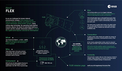
Measuring photosynthetic fluorescence - ESA's FLEX mission
Learn about ESA's upcoming FLEX mission, which is dedicated to gathering information about photosynthetic activity to shed light on the functioning of Earth's vegetation, in our latest infographic.
News - Data Release news
Full European Landsat data collection now available under the same catalogue
The Full European Landsat data collection, from Landsat-1 to Landsat-8, is now available under the same catalogue
News - Infographics
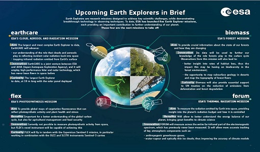
What are the next Earth Explorers?
Learn about the planned missions in the Earth Explorers programme - EarthCARE, Biomass, FLEX, and FORUM - which will further our understanding of Earth’s climate.
Event - Conference
Living Planet Symposium 2022
Learn about the 2022 edition of ESA's Living Planet Symposium.
News - Thematic area articles
Space helps monitor Earth’s changing biosphere
Earth’s biosphere is continually changing. Through its pioneering Earth observation missions, ESA is making critical contributions to monitor these changes and their impacts on Earth’s water and carbon cycles.


