- All Categories (45)
- Data (2)
- News (6)
- Events (8)
- Campaigns (3)
- Documents (26)
Event - Conference
International Symposium on Sea Ice 2023
The International Glaciological Society, the Alfred-Wegener-Institute, Helmholtz-Zentrum für Polar- und Meeresforschung, and the University of Bremen jointly organize the symposium which will be held in Bremerhaven, Germany from 4 to 9 June 2023.
News - Thematic area articles
Monitoring water on Earth's surface
ESA's Earth observation satellites are playing a leading role in furthering our understanding of how Earth's terrestrial hydrosphere is being influenced by humankind.
News - Thematic area articles
Global understanding of Earth's land surfaces greatly boosted by satellite data
ESA perform land surface monitoring with a range of instruments onboard satellites acquiring optical and radar data. Collections of data from these missions are freely available for research purposes.
Document - Product Readme Note

SMOS-Wind-Data-Service-Read-Me-First-Note.pdf
A Read Me First Note for the SMOS Wind Data Service (SMOS Near Real Time Sea Surface Wind Speed Processor)
News - Data Release news
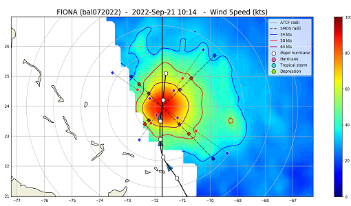
Minor Update for the SMOS Near Real Time Sea Surface Wind Speed Processor
An updated version of the SMOS Near Real Time Sea Surface Wind Speed Processor - Version 302 - was released on the 23 November 2022.
Event - Training

EO Summer School 6
ESA's series of summer schools, on Monitoring of the Earth System, aims to promote the exploitation of Earth observation data.
News - Thematic area articles

Satellite data central to ocean monitoring
Over 95% of Earth’s water is found in our oceans, and yet sadly, oceans are under stress from climate change and pollution. Monitoring our oceans is vital for Earth’s survival and satellites are the primary means of long-term and independent observation of our vast ocean bodies and their associated coastal zones.
Document - Product Document

L2OSv700_release_note_20220321.pdf
This note summarises the quality of the SMOS Level 2 Sea Surface Salinity data products generated by version 7 of the Level 2 Processor.
News - Thematic area articles

Satellite data boost global understanding of land surface
Understanding our changing land surface is essential in the study of climate change. Satellites are used to monitor changes to the material that covers Earth’s surface, so-called land cover, such as vegetation and water.
Event - Workshop

Fringe 1996 Workshop
The workshop on ERS SAR Interferometry was open to scientists and students working in the field of Synthetic Aperture Radar (SAR) interferometry and its applications.
Event - Workshop
SEASAR 2008
The "Advances in SAR Oceanography from Envisat and ERS missions" was a thematic workshop on SAR remote sensing techniques for oceanography.
Document - Product Document
SMOS-Level-2-Sea-Surface-Salinity-release-note-v700.pdf
This note summarises the quality of the SMOS Level 2 Sea Surface Salinity data products generated by version 7 of the Level 2 Processor.
News - Success Stories

Using Satellite Data to Predict Floods and Droughts
Scientists are turning to remote sensing to fill the in-situ data gap in hydrological data models in some parts of the world.
Event - Workshop

POLinSAR 2013
The objectives of the PolInSAR 2013 workshop were to present the latest studies and results of SAR polarimetry and polarimetric interferometry.
Data - Announcement of Opportunity (Restrained)

Announcement of Opportunity for NoR
ESA invites submissions for the Network of Resources (NoR) call, which aims to support research, development and pre-commercial users to innovate their working practices, moving from a data download paradigm towards a 'bring the user to the data' paradigm.
Data - Fast Registration with immediate access (Open)
Envisat ASAR Wave Imagette Cross Spectra L1 [ASA_WVS_1P]
The ASAR Wave product is extracted from the combined SLC and Cross Spectra product, ASA_WVI_1P, which is generated from data collected when the instrument was in Wave Mode using the Cross Spectra methodology. The product is meant for Meteo users. The spatial coverage is up to 20 spectra acquired every 100 km, with a minimum coverage of 5km x 5km. The file size has a maximum of 0.2 Mbytes. Auxiliary data include Orbit state vector, Time correlation parameters, Wave Processing parameters ADS, Wave Geolocation ADS, SQ ADS. The product provides a continuation of the ERS-SAR wave mode data. Output: Wavelength range from 20 to 1000 m in 24 logarithmic steps.
Campaign

DOMEX-1
The purpose of the DOMEX experiment was to acquire the first combined, in-situ microwave emission measurements using C- and L-band radiometers.
Campaign
CoSMOS 2006
ESA conducted an airborne campaign to map sea surface salinity named "CoSMOS-OS" that took place in April 2006 over the Norway Sea off the coast of Stavenger.
Campaign
CoSMOS 2005, 2007, 2008, 2010
The Campaign for Validating the Operation of SMOS (coSMOS) was designed to acquire SMOS-like data so that the algorithms were fine-tuned and properly validated before the launch of SMOS mission in 2007.
Event - Workshop
POLinSAR 2019
ESA organised POLinSAR 2019, the 9th International Workshop on Science and Applications of SAR Polarimetry and Polarimetric Interferometry.