- All Categories (99)
- Data (19)
- News (21)
- Missions (1)
- Events (23)
- Tools (4)
- Activities (8)
- Campaigns (1)
- Documents (22)
Document - Technical Note

(A)ATSR Expert Support Laboratory FAST Level 1b Product Definition
(A)ATSR Expert Support Laboratory FAST Level 1b Product Definition.pdf
Document - Conference Presentation - Poster

04_OCT2013_ESA-EO_programmes.pdf
ESA EO missions and their exploitation for science and applications ESA
Event - Training

2nd Advanced Training Course on Ocean Remote Sensing 2009
This advanced training course focused on ocean remote sensing theory and applications.
Event - Workshop

2nd Space for Hydrology Workshop
The workshop aimed to assess the current stage of knowledge and activities in space-based hydrological observations and to exchange knowledge and know how with hydrologists and researchers.
Event - Training
3rd Advanced Training Course on Land Remote Sensing 2011
This 2011 advanced ESA training course focused on land remote sensing theory and applications.
Event - Conference

3rd ERS Symposium
The ESA Directorate for Observation of the Earth and its Environment held the 3rd ERS Symposium, in 1997, where many of the results from the ERS-1 and ERS-2 missions were presented and discussed by the scientific community.
Event - Training

4th Advanced Training Course in Land Remote Sensing
ESA organised the 4th Advanced Training Course in Land Remote Sensing which took place in Athens, Greece from 1 to 5 July 2013
News - Success Stories
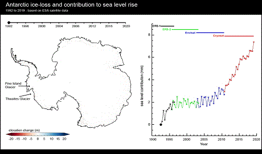
A quarter of glacier ice in West Antarctica is now unstable
Scientists have discovered warming ocean waters have caused ice to thin so rapidly that 24% of glacier ice in West Antarctica is now affected.
Event - Training
Advanced Training Course in Land Remote Sensing 2012
The 2012 advanced training course focused on land remote sensing theory and applications.
Event - Training
Advanced Training Course in Ocean Remote Sensing 2011
Within the framework of the Dragon Programme, a joint collaboration between the European Space Agency (ESA) and the Chinese Ministry of Science and Technology (MOST), ESA and NRSCC are providing a series of advanced thematic training courses on remote sensing applications hosted by university and research institutions in P.R. China.
Document - Product Document

ANNEX-A-ERS-1-ALT-RAW-Products-CCT-Format-Specification.pdf
Historical Document.This document deals with the product specification of the Altimeter Raw Data Product which provides the user with annotated, uncorrected altimeter measures, sensor parameters and sensor characteristics.
Document - Product Document
ANNEX-B-ERS-1-ALT-FDC-Products-CCT-Format-Specifications.pdf
This document deals with the product specification of the Altimeter Fast Delivery Copy. Valid for data processed up until July '95 when there was a switch from CEOS to CCSDS.
Document - Product Document
Annex-D-ERS-1-ALT-OPR-Product-CCT-Format.pdf
This product aims at providing the users with geophysically corrected altimeter measures over ocean, including all the engineering corrections and all the geophysical corrections due to the troposphere, the ionosphere and the electromagnetic bias. In addition, the surface altitude over the ellipsoid is calculated, correcting for the surface elevation due to tides and geoid.
Document - Product Document
Annex-E-ERS-1-ALT-WDR-Products-CCT-Format-Specifications.pdf
This product consists of the altimeter transcribed raw data with associated immediately available calibrations, corrections, geolocation and characterisation. This product is routinely generated on receipt of altimeter data at UK-PAF.
Data - Announcement of Opportunity (Restrained)

Announcement of Opportunity for G-POD
ESA is offering all scientists the possibility to perform bulk processing and/or validation of their own algorithms exploiting the large ESA Earth-observation archive.
Event - Workshop
Applications of the ERS Along Track Scanning Radiometer Workshop 1999
The workshop on ERS mission's Along Track Scanning Radiometer (ATSR) instrument gathered researchers and specialists working on different applications of the mission.
Campaign

BACCHUS-DOC
The BACCHUS-DOC Radar and Optical Campaign was an area mapping project of vineyards near Frascati (Italy). ESA required high resolution geo-referenced airborne SAR data of different wavelength and polarisation (preferably polarimetric).
Data - Campaigns (Open)
BACCHUS-DOC
The BACCHUS-DOC Radar and Optical Campaign was an area mapping project of vineyards near Frascati (Italy). ESA required high resolution geo-referenced airborne SAR data of different wavelength and polarisation (preferably polarimetric).
Event - Workshop
CEOS-IVOS Workshop on Inter-comparison of Large Scale Optical and Infrared Sensors
The 2004 workshop was an opportunity to present and exchange experiences and knowledge from work on inter-comparing large scale optical sensors at different product levels.
Document - Conference Presentation - Poster
D4P2a_Minchella_NEST_LTC2013.pdf
D4P2a Hands on using NEST - Interferogram generation over the Etna Volcano, Italy A. Minchella, M. Foumelis