- All Categories (25)
- Data (1)
- News (10)
- Missions (2)
- Events (8)
- Tools (1)
- Activities (3)
Event - Conference
3rd ERS Symposium
The ESA Directorate for Observation of the Earth and its Environment held the 3rd ERS Symposium, in 1997, where many of the results from the ERS-1 and ERS-2 missions were presented and discussed by the scientific community.
Event - Workshop
Applications of the ERS Along Track Scanning Radiometer Workshop 1999
The workshop on ERS mission's Along Track Scanning Radiometer (ATSR) instrument gathered researchers and specialists working on different applications of the mission.
Event - Conference
15 Years of Progress in Radar Altimetry Symposium
A Symposium on "15 Years of Progress in Radar Altimetry" and the annual meeting of the Ocean Surface Topography Science Team, the International Doris Service Workshop and the ARGO Workshop.
Event - Training
Advanced Training Course on Ocean Remote Sensing 2006
The objective of the course was to provide first-hand information on a broad range of ocean research topics including key principles of SAR, Radar Altimetry, Ocean Colour and Sea Surface Temperature measurements, processing algorithms, data products and their use in oceanographic applications.
Event - Meeting
20th GHRSST Science Team Meeting
The 20th GHRSST International Science Team meeting in 2019 brought together sea surface temperature experts to look at future innovations.
Mission - Heritage Missions
Envisat
Envisat was ESA's successor to ERS. Envisat carried ten instruments aboard for a wide range of Earth observing fields. The mission was operational from 2002 to 2012.
Mission - Earth Explorers
Aeolus
The Aeolus mission which was launched into space on 22 August 2018 and was retired on 30 April 2023, provided global observations of wind profiles from space to improve the quality of weather forecasts, and to advance our understanding of atmospheric dynamics and climate processes.
Data - Fast Registration with immediate access (Open)
Envisat ASAR Wave Imagette Cross Spectra L1 [ASA_WVS_1P]
The ASAR Wave product is extracted from the combined SLC and Cross Spectra product, ASA_WVI_1P, which is generated from data collected when the instrument was in Wave Mode using the Cross Spectra methodology. The product is meant for Meteo users. The spatial coverage is up to 20 spectra acquired every 100 km, with a minimum coverage of 5km x 5km. The file size has a maximum of 0.2 Mbytes. Auxiliary data include Orbit state vector, Time correlation parameters, Wave Processing parameters ADS, Wave Geolocation ADS, SQ ADS. The product provides a continuation of the ERS-SAR wave mode data. Output: Wavelength range from 20 to 1000 m in 24 logarithmic steps.
News - Success Stories
COVID-19: Aeolus and weather forecasts
The drop in commercial flights has led to fewer measurements for weather forecasts, but fortunately, ESA’s Aeolus satellite mission is helping to fill the gap.
Activity - Projects
Swarm Outflow
The Swarm+ Coupling High-Low Atmosphere Interactions: Ion Outflow ("Swarm+ Outflow") project, which began in May 2019, centres on using Swarm spacecraft to tackle unanswered questions around non-thermal processes that lead to ion outflow.
Event - Training
2nd Advanced Training Course on Ocean Remote Sensing 2009
This advanced training course focused on ocean remote sensing theory and applications.
Event - Workshop
SEASAR 2008
The "Advances in SAR Oceanography from Envisat and ERS missions" was a thematic workshop on SAR remote sensing techniques for oceanography.
News - Success Stories
Dust aerosol campaign validates Aeolus data
Prepared, implemented and executed by a consortium of French universities and research institutions, under the umbrella of the French Space Agency (CNES) and the French National Centre for Scientific Research (CNRS), the Clouds-Atmospheric Dynamics–Dust Interactions in West Africa (CADDIWA) campaign took place on Sal Island in Cape Verde, from 6 to 25 September 2021.
News - Success Stories
How Envisat helped to shape global understanding of Earth’s systems
Twenty years have passed since a ground-breaking European spacecraft designed to deliver unprecedented insight into the planet’s changing environment was lofted into orbit.
News - Success Stories
10 years of Envisat data help to illuminate ocean processes
A decade after Envisat beamed its final image to the planet, the pioneering ESA mission is continuing to foster improved understanding of Earth’s systems.
News - General News
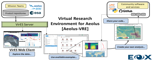
Launch of Aeolus VRE
The Aeolus Virtual Research Environment (VRE) is a cloud service, which provides users with a web-based development environment in the form of a JupyterLab workspace.
Tools - Processing
Aeolus VRE
The Aeolus Virtual Research Environment (VRE) is the latest extension to the VirES for Aeolus service, which offers more direct and in-depth data exploitation of the Aeolus mission. The VRE is a cloud service that provides a web-based development environment in the form of a JupyterLab workspace.
News - Thematic area articles
Satellite data central to ocean monitoring
Over 95% of Earth’s water is found in our oceans, and yet sadly, oceans are under stress from climate change and pollution. Monitoring our oceans is vital for Earth’s survival and satellites are the primary means of long-term and independent observation of our vast ocean bodies and their associated coastal zones.
News - Events and Proceedings
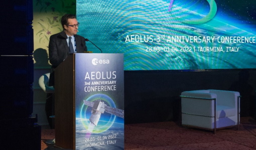
Exploring the prevailing achievements and future directions of Aeolus
A tight-knit community of European remote sensing experts converged on the Italian island of Sicily last month to discuss how the strong success of ESA’s Aeolus mission is shaping scientists’ understanding of the winds that sweep across the planet.
News - Thematic area articles
Space data help to unravel the complexities of Earth’s atmosphere
As the impacts of the climate crisis intensify, scientists are using ESA’s Earth observation archives to investigate atmospheric processes and their influences on the planet’s changing environment.


