- News
- Dust aerosol campaign validate...
Dust aerosol campaign validates Aeolus data
24 Jan 2022
Prepared, implemented and executed by a consortium of French universities and research institutions, under the umbrella of the French Space Agency (CNES) and the French National Centre for Scientific Research (CNRS), the Clouds-Atmospheric Dynamics–Dust Interactions in West Africa (CADDIWA) campaign took place on Sal Island in Cape Verde, from 6 to 25 September 2021.
Part of the larger international framework of the Joint Aeolus Tropical Atlantic Campaign (JATAC) supported by ESA, it aimed to investigate cloud-aerosol dynamics interactions offshore of West Africa, based on state-of-the-art ground, airborne and space-borne observations and regional numerical simulations.
The first objective of CADDIWA was to assess dust aerosol related effects on atmospheric dynamics, in the complex coastal environment offshore of Senegal. The second was to contribute to the calibration and validation of several space missions of interest to CNES and ESA, namely Aeolus and the Infrared Atmospheric Sounding Interferometer (IASI) aboard EUMETSAT’s MetOp-C satellite, as well as to verify algorithms for upcoming ESA mission EarthCARE and collect cloud data for the preparation of Earth Explorer 11 candidate mission Wivern.
An ideal location to study Saharan dust
Cape Verde is located immediately downstream of the dust plumes from the Sahel and Sahara that exit the African continent in September, while being advected westward by the easterly flow around 4 km above mean sea level. This makes it a perfect location to study the impact of the dust load on African Easterly Waves (AEWs) and other tropical wave development over the Atlantic Ocean.
Cape Verde is also ideally located to monitor interesting weather phenomena, such as the remains of continental Mesoscale Convective Systems (MCSs), as they evolve in the complex coastal environment and interact with the atmospheric circulation, the ocean and dust. This complex dynamical and compositional environment offshore of West Africa may very occasionally lead to the development of hurricanes in the region, as well as downstream from Cape Verde.
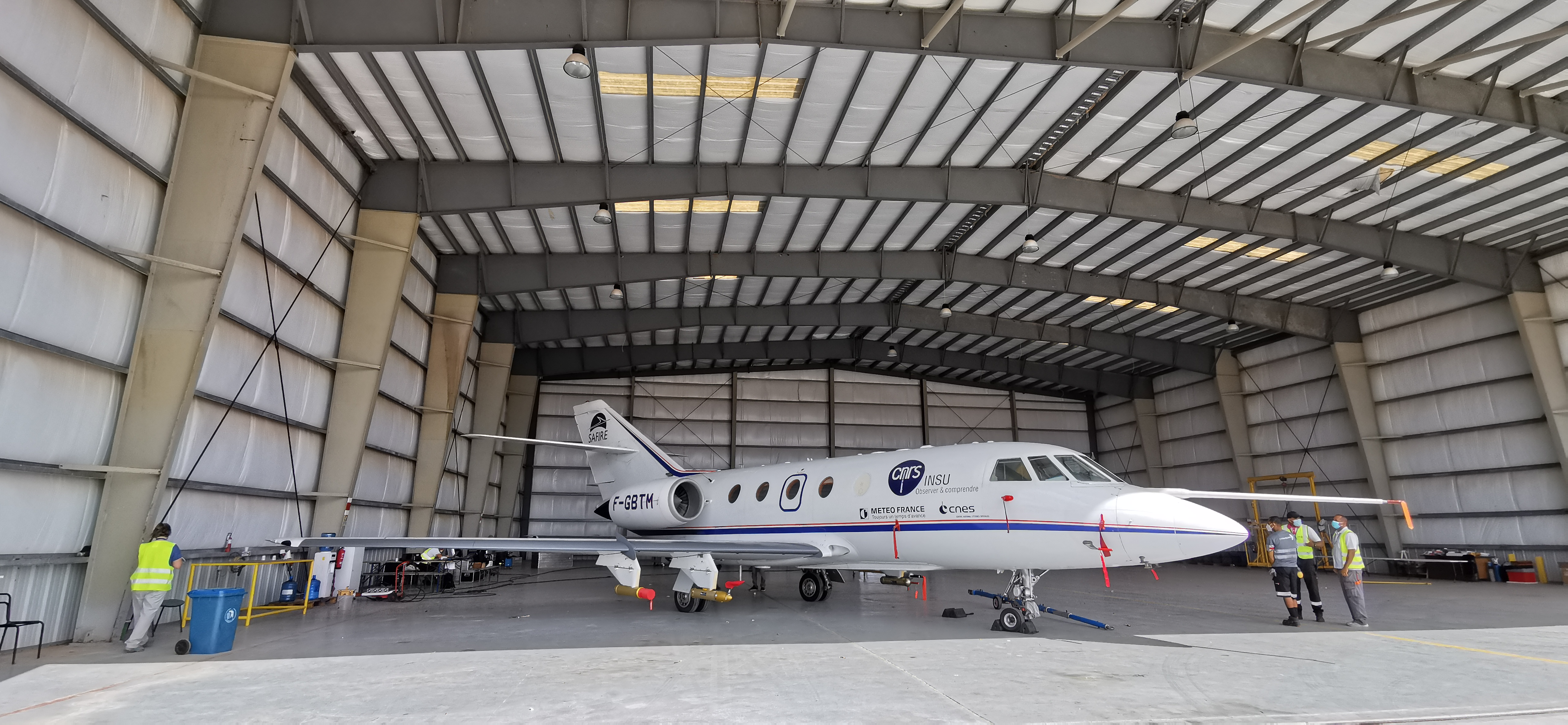
A flying scientific laboratory
CADDIWA was an aircraft-based campaign that used the SAFIRE Falcon 20 to collect measurements above Cape Verde. Its operations were coordinated with those of two other aircraft, the Slovenian Advantic WT-10 and the DLR Falcon 20 as well as with ground-based supersites such as the Cape Verde Atmospheric Observatory (CVAO) and the ground-based component of JATAC, ASKOS, operated from the Ocean Science Centre in Mindelo (OSCM) located on São Vicente island.
Aurélien Bourdon, head of SAFIRE, presents the SAFIRE Falcon 20’s modifications that made it an ideal aircraft for the CADDIWA campaign scientific goals.
The SAFIRE Falcon 20 was deployed from the Amilcar Cabral International Airport, where it shared a hangar with DLR’s Falcon 20. The purpose of each flight was determined by weather forecasts based on two atmospheric models of the French research community, Meso-NH and CHIMERE, which were already successfully deployed in numerous field campaigns.
Dedicated calibration and validation underflights for Aeolus and IASI were executed in more cloud-free conditions while EarthCARE and Wivern preparation flights took place in cloudier weather. For Aeolus orbits, long stacked underpasses with the Falcon 20 were favoured (one above the Saharan Aerosol Layer and one within it) to allow for the documentation of aerosol and wind gradients and to acquire enough wind and aerosol data to intercompare with a significant number of L2A and L2B Aeolus products profiles.
Instrumentation synergy
The SAFIRE Falcon 20 was equipped with a payload consisting of a radar-lidar system, radiometers, dropsondes, in situ dynamics, thermodynamics and aerosol/cloud microphysics probes covering the entire dust size spectrum as well as that of cloud particles.
The radar-lidar system was made up of two instruments: the Leandre New Generation (LNG) high-spectral-resolution aerosol/cloud Doppler lidar and the Radar Airborne System Tool for Atmosphere (RASTA) Doppler cloud radar.
Hélène Collomb, research engineer at LATMOS, presents the LNG lidar and how it is operated during Falcon 20 SAFIRE flights.
The LNG lidar retrieved wind measurements in clear air that will be used for Aeolus validation and supported another major CADDIWA campaign goal: the assessment of the effects of dust aerosols on atmospheric dynamics in the region around Cape Verde. The RASTA radar meanwhile was used to take measurements during cloudy weather conditions, complimenting lidar data to provide a comprehensive look at atmospheric profiles.
Quitterie Cazenave, research engineer at LATMOS, presents the RASTA radar aboard the SAFIRE Falcon 20.
The SAFIRE Falcon was also equipped with four external microphysics probes: two for aerosol and two for cloud measurements. Together with the data collected by the LNG lidar, the microphysics measurements provide a qualified dataset of aerosol-related optical properties to benchmark the Aeolus L2A products.
Pierre Coutris, research engineer at CNRS, presents SAFIRE Falcon's microphysics probes, their uses and how they are operated.
Ideal weather for a successful campaign
During the CADDIWA campaign, four African easterly waves passed south of Cape Verde from 6 to 21 September. Two of them led to weather events that affected Sal Island directly: a tropical disturbance on 11 to 12 September, associated with the second African easterly wave of the period and tropical storm Rose on 18 to 19 September, associated with the fourth wave. Three episodes of Saharan air transport also affected the area around the Cape Verde Islands: the first on 9 to 10 September, the second from 14 to 18 September and the last from 21 September onwards.
The SAFIRE Falcon carried out nine flights during the CADDIWA campaign, for a total of 32 hours flown and 46 dropsondes dropped. The varied and favourable weather conditions allowed the CADDIWA campaign to successfully achieve its main campaign objectives. It performed an analysis of the atmospheric environment before the passage of a tropical disturbance and a tropical storm, in relation to the cyclonic circulation associated with an African Easterly Wave.
The campaign validated Aeolus L2 products (wind and aerosols) along that satellite’s orbits passing near the island of Sal (two descending tracks in the morning and three ascending tracks), thanks in particular to the measurements of the LNG lidar in so-called Aeolus mode, in off-axis view at 37° from nadir.
The feasibility of the concept of Earth Explorer 11 candidate mission Wivern’s observations for the mapping of winds, precipitations and cloud properties on a global scale, was tested using the RASTA radar. The CADDIWA campaign further supported the preparation of algorithms for the EarthCARE radar-lidar mission using synergistic data from the RASTA radar and the LNG lidar (RALI) as well as the microphysics probes, obtained during the flights executed on convective cells in the environment of tropical depressions and tropical storms.
A paper detailing the campaign has already been published in number 115/2021 of the French journal La Météorologie. The findings will be presented to the Aeolus community in March 2022, during the Aeolus 3rd Anniversary Conference.