- Learn & Discover
- How Envisat helped to shape gl...
How Envisat helped to shape global understanding of Earth’s systems
01 Mar 2022
Twenty years have passed since a ground-breaking European spacecraft designed to deliver unprecedented insight into the planet’s changing environment was lofted into orbit.
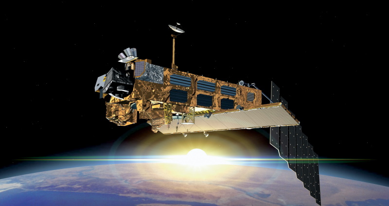
Envisat – the largest civilian Earth observation satellite ever sent to space – launched on 1 March 2002, onboard an Ariane 5 rocket from ESA’s Spaceport in French Guiana.
This marked the beginning of a decade-long endeavour that greatly augmented Europe’s contributions to environmental monitoring, providing uninterrupted observations of the planet’s land, atmosphere, oceans and ice caps.
Envisat succeeded ESA’s tandem remote-sensing ERS mission, ensuring the continuous and enduring delivery of a wealth of data that has a fundamental, ongoing role in society’s response to the climate crisis.

It continued to provide environmental information for 10 years – double its expected lifespan – until communications with the satellite were unexpectedly lost in April 2012, triggering the end of the mission.
Like its predecessors, Envisat was placed in a sun-synchronous near-Earth Polar orbit, circling the planet once every 100 minutes at an altitude of some 800 kilometres.
The 8-tonne school bus-sized satellite hosts a suite of 10 innovative instruments for monitoring the planet’s atmosphere and its surface. These operated over a wide range of the electromagnetic spectrum, ranging from microwaves to ultraviolet.
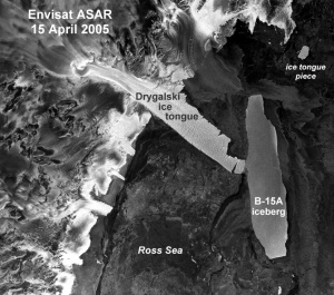
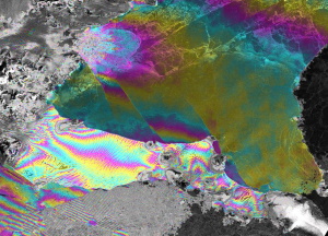
Amongst others, the mission’s instruments include an Advanced Synthetic Aperture Radar (ASAR) for high-resolution wide-swath radar images, several optical and infrared spectrophotometry instruments, and a precise orbit determination instrument.
Data download to Earth was ensured through a network of ground stations located in Kiruna, Sweden; Fucino, Italy; and Svalbard, Norway; as well as through ESA’s Artemis data relay satellite, enabling data downloads directly to the Payload Data Control Centre at ESA’s ESRIN facility in Frascati, Italy.
During its lifetime, Envisat circled Earth over 50,000 times and delivered over 1000 terabytes of data, resulting in the publication of some 7000 scientific papers, as well as facilitating the development of several operational and commercial applications.
The mission provided data that helped to characterise numerous key aspects of Earth’s systems, including melting Arctic sea ice, global sea level rise, fluctuations in the extent of the Antarctic ozone hole, and ocean currents and chlorophyll concentrations.
This helped scientists to better understand the long-term environmental changes impacting the planet, at a time when international concerns about global warming were beginning to intensify.
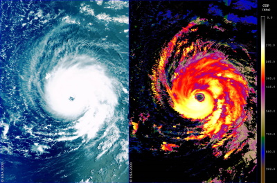
Envisat also enabled operational services to deliver rapid crisis responses by monitoring the extent of environmental catastrophes, such as floods, oil spills, volcanic eruptions and earthquakes.
In addition, the mission provided valuable information that helped Europe to implement its next generation of Earth observing satellites – the Copernicus Sentinels.
Mirko Albani, Heritage Missions Manager at ESA, states, “Envisat ensured continuity of the observations started with the ERS programme and provided us with new insights on our planet, the chemistry of our atmosphere, the behaviour of our oceans, and the effects of humankind’s activity on our environment.
“The wealth of data delivered by Envisat are still widely used for scientific research and applications in several domains, including climate change monitoring,” concluded Albani.
Envisat has now been inactive for a decade, but the pioneering mission makes important contributions to climate science to this day.
Through ESA’s Heritage Space Programme, the freely available data archive is being maintained and continuously improved to build harmonised time series with Copernicus Sentinel data.