- All Categories (41976)
- Data (71)
- News (251)
- Missions (23)
- Events (67)
- Tools (19)
- Activities (19)
- Campaigns (17)
- Documents (41509)
News - Events and Proceedings

Φ-Week Triumphs
In its fourth edition, Φ-Week presented the scientific community with amazing opportunities and projects—thus running alongside innovation at 360 degrees.
News - Success Stories
Young scientists bid farewell to ESA's wind mission
Students and early career researchers are saying an emotional goodbye to Aeolus ahead of its upcoming reentry.
News - Success Stories
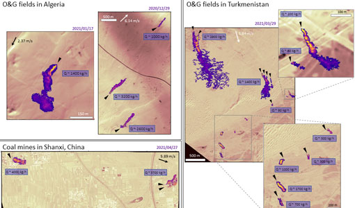
WorldView-3 satellite maps methane plumes at very high spatial resolution
Substantial advances have been made in the last years towards the detection and quantification of methane emissions from space- very high spatial resolution data from the WorldView-3 satellite can fill an important observational gap in the remote sensing of methane point emissions.
News - Success Stories

WorldView-3 helps to track offshore methane plumes from oil and gas
Scientists have used Earth observation data to reveal enormous methane plumes spilling out from an offshore oil and gas production rig in the Gulf of Mexico. This represents a significant breakthrough in the monitoring of industrial methane emissions from space.
Event - Conference

World Soils 2019 User Consultation Meeting
The World Soils 2019 User Consultation Meeting focussed on space-based EO tools for mapping and monitoring soils. The meeting brought together stakeholders and remote sensing experts.
Event - Meeting

World Ocean Circulation User Consultation Meeting 2019
The World Ocean Circulation User Consultation Meeting took place in 2019 with the aim to prepare a roadmap for new initiatives on ocean circulation research and applications.
Event - Workshop

Workshop on International Cooperation in Spaceborne Imaging Spectroscopy
The workshop aimed to recommend future international coordination permitting cooperation in the deployment, operation, and exploitation of space-based imaging spectrometers for terrestrial and coastal scientific and operational applications.
Data - EO Sign In Authentication (Open)

VT GOCE Data
This collection contains the VT GOCE software and associated data set needed to run the software that is used for GOCE data visualisation.
Event - Workshop
Volcanic Ash Monitoring - ESA/EUMETSAT Workshop
On 14 April 2010 the Icelandic volcano Eyjafjalla erupted and had been ejecting immense plumes of ash and sulphur into the atmosphere. The workshop was held in response to the emergency.
News - Success Stories
Vision-1 to enable cutting-edge science and spur innovation
Vision-1 – which is the result of a collaboration between Airbus Defence and Space and Surrey Satellite Technology Ltd. (SSTL) – provides sub-metric imagery to support activities across many industries, including urban planning, agricultural monitoring, land classification, natural resource management and disaster monitoring.
News - Data Release news
Vision-1 data now open to users
In the framework of the Third Party Missions programme, ESA is offering, for scientific research and application development, access to archive and new tasking data from the Vision-1 mission upon submission and acceptance of a project proposal.
Mission - Third Party Missions
Vision-1
Launched on 16 September 2018, Vision-1 offers orthorectified products with resolution up to 87 cm in panchromatic mode and 3.48 in multispectral mode as standard.
Tools - Analysis
VirES for Swarm
VirES adds discovery and visual analytics capabilities to the European Space Agency's online data access services established for the Swarm mission.
News - Data Release news
Version 2.0 of GOCE thermosphere reprocessed data released
Version 2.0 of the GOCE thermosphere dataset is now available on the GOCE Online Dissemination Service.
Document - Product Cal/Val Plan/Report

Validation-auroral-electrojet-auroral-boundaries-estimated-from-swarm.pdf
This document provides the validation report for the Swarm Level 2 AEBS products.
Document - User Guide

User's Guide to NASDA's SAR products
This document summarises the algorithms to obtain geometric and radiometric information from NASDA's JERS SAR products. It includes a list of the physical information to be derived from the JERS SAR products. Not applicable for JERS SAR data generated by ESA (only for NASDA data).
Document - Software Verification Plan/Report

User Toolbox Requirements Document - GOCE User Toolbox Specifications (GUTS)
Deliverable: WP2000: This document provides user requirement for the GOCE User Toolbox, designed around the GOCE mission.
Document - User Guide
User Guide for JERS-1 SAR data format
This document describes the Computer Compatible Tape (CCT) format and the film format for JERS-1's Synthetic Aperture Radar (SAR) data process in EOC. The EOC's CCT product conforms to the CEOS SAR data products format Standard.
Event - Workshop
URBIS24
URBan Insights from Space (URBIS24) Workshop will offer an insightful exploration of urban challenges and innovative EO-integrated solutions.
News - Data Release news
Updated Swarm EEF dataset released
An improved version of Swarm EEFxTMS_2F products (version 0203) is now available.