- All Categories (3249)
- Data (31)
- News (16)
- Missions (7)
- Events (16)
- Tools (3)
- Activities (1)
- Campaigns (4)
- Documents (3171)
Event - Workshop

11th International Workshop on PolInSAR and Biomass
Organised by ESA, the workshop will be held at Espaces Vanel Toulouse, France on the 19 - 23 June 2023
Document - Conference Presentation - Poster

1_Polarimetric_Soil_Moisture_Retrieval_Vegetated_Soils_in_TERENO.pdf
Polarimetric Decompositions for Soil Moisture Retrieval from Vegetated Soils in TERENO Observatories T. Jagdhuber [German Aerospace Center - DLR]
Document - Conference Presentation - Poster
1_POLinSAR2013_compact_v1.pdf
Time Series Decomposition Analysis for Compact Polarimetry S.R. Cloude [AEL Consultants - UK]
Document - Conference Presentation - Poster
1_PolinSAR2013_HJ.pdf
Interpretation Pol-InSAR Vegetation Signatures at X-Band H.J. Joerg [German Aerospace Center - DLR]
Document - Conference Presentation - Poster
2_Charbonneau_compact_pol.pdf
RCM Compact Polarimetry Applied to Watershed Study F. J. Charbonneau [Natural Resources Canada]
Event - Workshop

2nd CHRIS PROBA Workshop
This 2004 workshop was on the treatment of Compact High Resolution Images Spectrometer (CHRIS) data.
Document - Proceedings

2nd ERS Applications Workshop
Proceedings of the second ERS Applications Workshop held on 6-8 December 1995 in London, United Kingdom.
Event - Conference

3rd ERS Symposium
The ESA Directorate for Observation of the Earth and its Environment held the 3rd ERS Symposium, in 1997, where many of the results from the ERS-1 and ERS-2 missions were presented and discussed by the scientific community.
Event - Meeting

3rd Sentinel-2 Validation Team Meeting
This Sentinel-2 Validation Team (S2VT) meeting was the third edition of a meeting series, initiated in 2016. The S2VT is organised under the auspices of ESA, CNES, and ENSEEIHT.
Event - Training

Advanced Training Course in Land Remote Sensing 2012
The 2012 advanced training course focused on land remote sensing theory and applications.
Event - Conference
ALOS 2008 Symposium
The 2008 Joint PI Symposium of the ALOS Data Nodesa was a forum to exchange views on technical and scientific issues on the data exploitation.
Data - Fast Registration with approval (Restrained)
ALOS PALSAR products
The dataset contains all ESA acquisitions over the ADEN zone (Europe, Africa and the Middle East) plus some products received from JAXA over areas of interest around the world. Further information on ADEN zones can be found in this technical note. ALOS PALSAR products are available in following modes: Fine Beam Single polarisation (FBS), single polarisation (HH or VV), swath 40-70 km, resolution 10 m, temporal coverage from 02/05/2006 to 30/03/2011 Fine Beam Double polarisation (FBD), double polarisation (HH/HV or VV/VH), swath 40-70 km, resolution 10 m, temporal coverage from 02/05/2006 to 30/03/2011 Polarimetry mode (PLR), with four polarisations simultaneously: swath 30 km, resolution 30 m, temporal coverage from 26/08/2006 to 14/04/2011 ScanSAR Burst mode 1 (WB1), single polarisation: swath 250-350 km, resolution 100 m, temporal coverage from 12/06/2006 to 21/04/2011. Following processing levels are available: RAW (Level 1.0): Raw data generated by every downlink segment and every band. Divided into an equivalent size to one scene SLC (Level 1.1): Slant range single look complex product. Not available for WB1 GDH (Level 1.5): Ground range Detected, Normal resolution product GEC (Level 1.5): Geocoded product. The table summarises the ALOS PALSAR offer. Instrument mode Product type Processing level description JAXA processing level equivalent Fine Beam Single polarisation (HH or VV) FBS_RAW_0P Raw data generated by every downlink segment and every band. Divided into an equivalent size to one scene 1.0 FBS_GDH_1P Ground range Detected, Normal resolution product 1.5 FBS_GEC_1P Geocoded product 1.5 FBS_SLC_1P Slant range single look complex product 1.1 Fine Beam Double polarisation (HH/HV or VV/VH) FBD_RAW_0P Raw data generated by every downlink segment and every band. Divided into an equivalent size to one scene 1.0 FBD_GDH_1P Ground range Detected, Normal resolution product 1.5 FBD_GEC_1P Geocoded product 1.5 FBD_SLC_1P Slant range single look complex product 1.1 Polarimetry mode (4 polarisation) PLR_RAW_0P Raw data generated by every downlink segment and every band. Divided into an equivalent size to one scene 1.0 PLR_GDH_1P Ground range Detected, Normal resolution product 1.5 PLR_GEC_1P Geocoded product 1.5 PLR_SLC_1P Slant range single look complex product 1.1 ScanSAR Burst mode 1 (single polarisation) WB1_RAW_0P Raw data generated by every downlink segment and every band. Divided into an equivalent size to one scene 1.0 WB1_GDH_1P Ground range Detected, Normal resolution product 1.5 WB1_GEC_1P Geocoded product 1.5
News - Spotlight on EO community
An overview of the Biomass mission
In this video, Klaus Scipal - Biomass and SMOS Mission Manager - talks about ESA's upcoming Biomass mission.
Data - Announcement of Opportunity (Restrained)

Announcement of Opportunity for Aeolus Cal/Val
An Announcement of Opportunity call is open for the Aeolus mission. Scientists, new groups and individuals are invited to participate in Aeolus Cal/Val throughout the mission lifetime.
Data - Announcement of Opportunity (Restrained)

Announcement of Opportunity for S3VT (Sentinel-3 Validation Team)
In the framework of a Copernicus collaborative agreement ESA and EUMETSAT invite interested groups and individuals to support the Sentinel-3 Validation Team (S3VT).
Mission - Earth Explorers
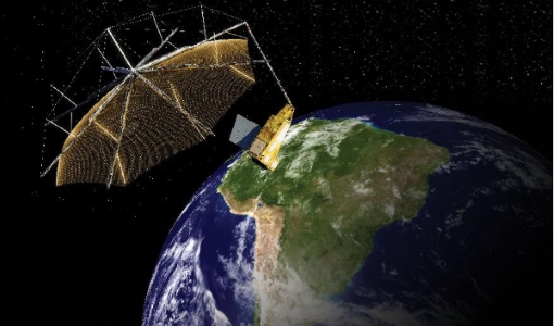
Biomass
The objective of the Biomass mission is to determine the global distribution of forest biomass.
Tools - Other
BioPAL
The Biomass Product Algorithm Laboratory (BioPAL) is an open-source scientific computing project, supporting the development of ESA's Biomass mission algorithms coded in Python.
Campaign

BioSAR 2007
The BioSAR campaign aimed to support geophysical algorithm development, calibration/validation and the simulation of future spaceborne Earth Observation missions.
Data - Campaigns (Open)
BioSAR 2007
The BioSAR campaign aimed to support geophysical algorithm development, calibration/validation and the simulation of future spaceborne Earth Observation missions.
Campaign

BioSAR 2008
The main objective of BioSAR-2 (BioSAR 2008) campaign was to record SAR data over boreal forests with topographic effects to investigate the effect on biomass retrieval.