- All Categories (3672)
- Data (83)
- News (74)
- Missions (28)
- Events (39)
- Tools (4)
- Activities (3)
- Campaigns (22)
- Documents (3419)
News - Success Stories

1 km resolution aerosol optical thickness retrieved from PROBA-V
The ESA SPAR@MEP project aims to deliver a long-term data record (LTDR) of aerosol optical properties and surface reflectance from SPOT-VGT and PROBA-V observations.
Event - Workshop

10 Years of GOME on ERS-2 Workshop
The workshop summarised 10 years of operation of the Global Ozone Monitoring Experiment (GOME) on board ERS-2.
Event - Workshop

11th International Workshop on PolInSAR and Biomass
Organised by ESA, the workshop will be held at Espaces Vanel Toulouse, France on the 19 - 23 June 2023
News - Data Release news

15 cm HD and 30 cm HD products added to EUSI ESA archive collections
Two new products, 15 cm HD and 30 cm HD, have been added to the collections from GeoEye-1, QuickBird-2, and WorldView (1 – 4).
Document - Conference Presentation - Poster

1_Polarimetric_Soil_Moisture_Retrieval_Vegetated_Soils_in_TERENO.pdf
Polarimetric Decompositions for Soil Moisture Retrieval from Vegetated Soils in TERENO Observatories T. Jagdhuber [German Aerospace Center - DLR]
Document - Conference Presentation - Poster
1_POLinSAR2013_compact_v1.pdf
Time Series Decomposition Analysis for Compact Polarimetry S.R. Cloude [AEL Consultants - UK]
Document - Conference Presentation - Poster
1_PolinSAR2013_HJ.pdf
Interpretation Pol-InSAR Vegetation Signatures at X-Band H.J. Joerg [German Aerospace Center - DLR]
Event - Conference
2024 European Polar Science Week
Polar regions are sentinels of climate change, biodiversity, and human resilience. European Polar Science Week is to bring together the European polar science community and reinforce European cooperation for polar science.
Document - Conference Presentation - Poster
2_Charbonneau_compact_pol.pdf
RCM Compact Polarimetry Applied to Watershed Study F. J. Charbonneau [Natural Resources Canada]
Event - Workshop
2nd CHRIS PROBA Workshop
This 2004 workshop was on the treatment of Compact High Resolution Images Spectrometer (CHRIS) data.
Document - Proceedings

2nd ERS Applications Workshop
Proceedings of the second ERS Applications Workshop held on 6-8 December 1995 in London, United Kingdom.
Event - Workshop
2nd Space for Hydrology Workshop
The workshop aimed to assess the current stage of knowledge and activities in space-based hydrological observations and to exchange knowledge and know how with hydrologists and researchers.
Event - Conference

3rd ERS Symposium
The ESA Directorate for Observation of the Earth and its Environment held the 3rd ERS Symposium, in 1997, where many of the results from the ERS-1 and ERS-2 missions were presented and discussed by the scientific community.
Event - Meeting

3rd Sentinel-2 Validation Team Meeting
This Sentinel-2 Validation Team (S2VT) meeting was the third edition of a meeting series, initiated in 2016. The S2VT is organised under the auspices of ESA, CNES, and ENSEEIHT.
Event - Workshop
4th CHRIS PROBA Workshop
Workshop on the treatment of Compact High Resolution Images Spectrometer (CHRIS) data.
News - Operational News
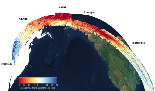
A Guide to Aeolus Range Bin Settings
After almost two years in space, Aeolus' near-real time observations have been assimilated into the Numerical Weather Prediction models of several European meteorological services, and have proven crucial during the COVID-19 pandemic, which led to a sharp decrease in meteorological observations.
Event - Training

Advanced Training Course in Land Remote Sensing 2012
The 2012 advanced training course focused on land remote sensing theory and applications.
Event - Workshop
Aeolus Cal/Val and Science Workshop
The ESA organised Aeolus Cal/Val virtual workshop was a forum for reporting on the mission status and product evolution, for informing and coordinating mission Cal/Val activities.
Activity - Quality
Aeolus DISC
The Aeolus DISC is the core element in ESA's data quality framework for the Aeolus mission, comprised of an international expert consortium to study and improve the data quality of Aeolus products.
Data - EO Sign In Authentication (Open)
Aeolus L2A Aerosol/Cloud optical product
The Level 2A aerosol/cloud optical products of the Aeolus mission include: Geo-located consolidated backscatter and extinction profiles Backscatter-to-extinction coefficient LIDAR ratio, scene classification Heterogeneity index Attenuated backscatter signals. Resolution: Horizontal resolution of L2A optical properties at observation scale (~87 km); Exceptions are group properties (horizontal accumulation of measurements from ~3 km to ~87 km) and attenuated backscatters (~3 km). Note: The resolution of "groups" in the L2A can only go down to 5 measurements at the moment, i.e. ~15 km horizontal resolution. This could be configured to go to 1 measurement - Vertical resolution 250-2000 m (Defined by Range Bin Settings).