- All Categories (63)
- Data (20)
- News (15)
- Missions (4)
- Events (15)
- Tools (1)
- Campaigns (3)
- Documents (5)
Event - Training

10th Advanced Training Course on Land Remote Sensing EO and AI for Forestry
This ESA course was dedicated to training the next generation of EO scientists and experts working in forestry domain to exploit data from EO missions and use AI for science and applications development.
Document - Conference Presentation - Poster

1_Polarimetric_Soil_Moisture_Retrieval_Vegetated_Soils_in_TERENO.pdf
Polarimetric Decompositions for Soil Moisture Retrieval from Vegetated Soils in TERENO Observatories T. Jagdhuber [German Aerospace Center - DLR]
Document - Conference Presentation - Poster
2_Charbonneau_compact_pol.pdf
RCM Compact Polarimetry Applied to Watershed Study F. J. Charbonneau [Natural Resources Canada]
Event - Workshop

2nd MERIS/AATSR User Workshop
The workshop addressed the utilisation of MERIS and AATSR data for remote sensing of open oceans, coastal waters, land surfaces and atmospheric processes.
Event - Training

3rd Advanced Training Course on Ocean Remote Sensing 2013
The 3rd Advanced Training Course on Ocean Remote Sensing was held from 23 to 27 September 2013 in Cork, at the National Maritime College of Ireland.
Event - Workshop
4th CHRIS PROBA Workshop
Workshop on the treatment of Compact High Resolution Images Spectrometer (CHRIS) data.
Document - Conference Presentation - Poster
5-Touzi_wetland_PolinSAR13.pdf
Investigation of Polarimetric L-band ALOS and C-band RADARSAT-2 for peatland subsurface water flow monitoring R. Touzi [Canada Centre for Remote Sensing]
Document - Conference Presentation - Poster
8_PolinSAR2013_soil_moisture_wetland_session_summary_Fina.pdf
Applications of SAR Polarimetry on Land: Soil Moisture and Wetlands
Data - Campaigns (Open)

AfriSAR 2016
In order to further support the BIOMASS mission development, especially concerning the mission concept verification and the development of geophysical algorithms, ESA funded the AfriSAR campaign.
Event - Conference

ALOS 2008 Symposium
The 2008 Joint PI Symposium of the ALOS Data Nodesa was a forum to exchange views on technical and scientific issues on the data exploitation.
News - Spotlight on EO community
An overview of the Biomass mission
In this video, Klaus Scipal - Biomass and SMOS Mission Manager - talks about ESA's upcoming Biomass mission.
Data - Announcement of Opportunity (Restrained)

Announcement of Opportunity for NoR
ESA invites submissions for the Network of Resources (NoR) call, which aims to support research, development and pre-commercial users to innovate their working practices, moving from a data download paradigm towards a 'bring the user to the data' paradigm.
Data - Announcement of Opportunity (Restrained)
Announcement of Opportunity for NovaSAR-1
ESA is launching an Announcement of Opportunity for the international scientific community to access data from the NovaSAR-1 mission for science and EO-based applications development.
Event - Workshop
Aquaculture User Consultation
The main goal of the workshop was to define a detailed set of user requirements for the future ESA Aquaculture project.
Mission - Earth Explorers
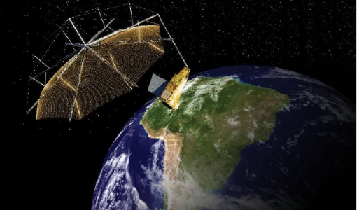
Biomass
The objective of the Biomass mission is to determine the global distribution of forest biomass.
Campaign

BioSAR 2007
The BioSAR campaign aimed to support geophysical algorithm development, calibration/validation and the simulation of future spaceborne Earth Observation missions.
Data - Campaigns (Open)
BioSAR 2007
The BioSAR campaign aimed to support geophysical algorithm development, calibration/validation and the simulation of future spaceborne Earth Observation missions.
Campaign

BioSAR 2008
The main objective of BioSAR-2 (BioSAR 2008) campaign was to record SAR data over boreal forests with topographic effects to investigate the effect on biomass retrieval.
Data - Campaigns (Open)
BioSAR 2008
The main objective of BioSAR-2 (BioSAR 2008) campaign was to record SAR data over boreal forests with topographic effects to investigate the effect on biomass retrieval.
Campaign

BioSAR 2010
The BioSAR-3 (BioSAR 2010) campaign was specifically planned and implemented to investigate possibilities for a future spaceborne P-band polarimetric and interferometric SAR with a life-time of multiple years.