- All Categories (37)
- Data (4)
- News (14)
- Missions (2)
- Events (10)
- Tools (1)
- Activities (2)
- Campaigns (1)
- Documents (3)
News - General News
Go-to guide to Third Party Mission data offering
ESA’s latest Third Party Missions Data Access Guide has been published, providing technical details and information on available data collections for all current or past Third Party Missions.
News - Thematic area articles
How to use space data to probe humankind’s ancient past
Data disseminated by ESA’s Third Party Missions (TPM) programme are enabling archaeological investigations that could help to unravel the mysteries of past societies and cultures.
News - Success Stories
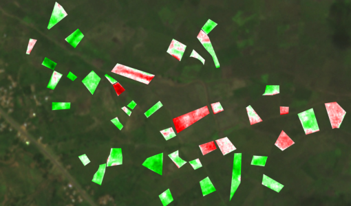
Synergy of space data helps modernise irrigation systems
The growing demands on agriculture, coupled with the climate crisis, are pressurising Earth’s valuable freshwater resources and making assessment of water practices ever more important.
News - Success Stories
ESA missions help to reveal worldwide lake water loss trend
Climate change, human consumption and sedimentation are depleting more than half of the world’s biggest lakes of water, according to a ground-breaking analysis that drew on three decades of satellite data.
News - Thematic area articles
Remote sensing data map impacts of natural hazards
As climate change increases the frequency and severity of natural disasters, remote sensing data can warn about extreme events and help tackle emergency situations.
Data - Announcement of Opportunity (Restrained)
Announcement of Opportunity for S3VT (Sentinel-3 Validation Team)
In the framework of a Copernicus collaborative agreement ESA and EUMETSAT invite interested groups and individuals to support the Sentinel-3 Validation Team (S3VT).
News - General News
How SNAP facilitates access to ESA Third Party Missions data
The tool – called the Sentinel Applications Platform (SNAP) – incorporates high-quality remote sensing data from numerous missions, including those operated by the agency’s international partners, known as Third Party Missions (TPM).
News - Data Release news
Two new ESA archive collections have been opened for PlanetScope and SkySat
PlanetScope ESA archive and SkySat ESA archive collections are available through ESA’s Third Party Missions programme via Fast Approval Registration.
Data - Fast Registration with approval (Restrained)
SkySat ESA archive
The SkySat ESA archive collection consists of SkySat products requested by ESA supported projects over their areas of interest around the world and that ESA collected over the years. The dataset regularly grows as ESA collects new products. Two different product types are offered, Ground Sampling Distance at nadir up to 65 cm for panchromatic and up to 0.8m for multi-spectral. EO-SIP Product Type Product Description Content SSC_DEF_SC Basic and Ortho scene Level 1B 4-bands Analytic /DN Basic scene Level 1B 4-bands Panchromatic /DN Basic scene Level 1A 1-band Panchromatic DN Pre Sup resolution Basic scene Level 3B 3-bands Visual Ortho Scene Level 3B 4-bands Pansharpened Multispectral Ortho Scene Level 3B 4-bands Analytic/DN/SR Ortho Scene Level 3B 1-band Panchromatic /DN Ortho Scene SSC_DEF_CO Ortho Collect Visual 3-band Pansharpened Image Multispectral 4-band Pansharpened Image Multispectral 4-band Analytic/DN/SR Image (B, G, R, N) 1-band Panchromatic Image The Basic Scene product is uncalibrated, not radiometrically corrected for atmosphere or for any geometric distortions inherent in the imaging process: Analytic - unorthorectified, radiometrically corrected, multispectral BGRN Analytic DN - unorthorectified, multispectral BGRN Panchromatic - unorthorectified, radiometrically corrected, panchromatic (PAN) Panchromatic DN - unorthorectified, panchromatic (PAN) L1A Panchromatic DN - unorthorectified, pre-super resolution, panchromatic (PAN) The Ortho Scene product is sensor and geometrically corrected, and is projected to a cartographic map projection: Visual - orthorectified, pansharpened, and colour-corrected (using a colour curve) 3-band RGB Imagery Pansharpened Multispectral - orthorectified, pansharpened 4-band BGRN Imagery Analytic SR - orthorectified, multispectral BGRN. Atmospherically corrected Surface Reflectance product. Analytic - orthorectified, multispectral BGRN. Radiometric corrections applied to correct for any sensor artifacts and transformation to top-of-atmosphere radiance. Analytic DN - orthorectified, multispectral BGRN, uncalibrated digital number imagery product Radiometric corrections applied to correct for any sensor artifacts Panchromatic - orthorectified, radiometrically correct, panchromatic (PAN) Panchromatic DN - orthorectified, panchromatic (PAN), uncalibrated digital number imagery product The Ortho Collect product is created by composing SkySat Ortho Scenes along an imaging strip. The product may contain artifacts resulting from the composing process, particular offsets in areas of stitched source scenes. Spatial coverage: Check the spatial coverage of the collection on a map available on the Third Party Missions Dissemination Service. As per ESA policy, very high-resolution imagery of conflict areas cannot be provided.
News - General News
Campaign using surface reflectance data to support validation of Earth observation products
Scientists from around the world are set to take part in a drone monitoring campaign and inter-comparison exercise that will deliver surface reflectance data to support the validation of Earth observation products.
News - Data Release news
PlanetScope and Skysat data available through ESA’s Third Party Missions Programme
Through ESA’s Third Party Missions Programme, researchers, scientists and companies from around the world can apply to access Planet’s high-frequency, high-resolution satellite data for non-commercial use.
News - Success Stories
Predicting crop yield using Planet data
The world’s population continues to grow, while the climate crisis is raising Earth’s temperatures and increasing the likelihood of extreme weather events – all of which affect food security.
News - Infographics
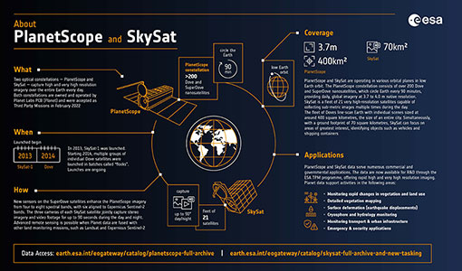
PlanetScope and SkySat - The high-resolution nanosatellite constellation
Find out more about the PlanetScope and SkySat missions in our new infographic.
Event - Workshop
Space and the Arctic 2009 Workshop
Temperatures in the Arctic are rising at an unprecedented rate. This workshop looked at the needs and challenges of working and living in the rapidly changing Arctic and explore how space-based services might help to meet those needs.
Event - Workshop
Insurance Industry Workshop on Earth Observation
This ESA workshop examined the potential value of satellite Earth Observation data to the insurance industry.
News - Infographics
An overview of ESA's Third Party Missions programme
ESA’s Third Party Missions programme consists of almost 50 satellite missions, which are owned by organisations around the world. ESA has agreements with these organisations to acquire, process, and distribute data from their missions
Document - Technical Note
Guidelines-for-the-SAR-Delay-Doppler-L1b-Processing.pdf
The purpose of this document is to present the major theoretical guidelines for a standard SAR (aka Delay Doppler) Processing from low-level data (FBR, aka L1a) to multi-looked waveforms (L1b) in case of the Closed-Burst instrument transmission mode (CryoSat-2 and Sentinel-3 case).
Activity - General activities
EO Science for Society
ESA's Earth Observation Science for Society programme aims to promote scientific exploitation of satellite data, forges new scientific discoveries and pioneers new services, stimulating downstream industrial and economic growth.
Tools - Other
Hydrology TEP
The Hydrology Thematic Exploitation Platform (TEP) enables access, processing, uploading, visualisation, manipulation and comparison of hydrological data.
Mission - Copernicus Sentinels
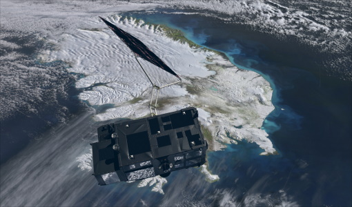
Copernicus Sentinel-3
Copernicus Sentinel-3 is an European Earth Observation satellite mission developed to support Copernicus ocean, land, atmospheric, emergency, security and cryospheric applications.

