- News & Events
- How SNAP facilitates access to...
How SNAP facilitates access to ESA Third Party Missions data
13 Sep 2022
Researchers and developers from around the world are unlocking the huge potential of Earth observation data, thanks to an open-access analysis and processing platform devised by ESA.
The tool – called the Sentinel Applications Platform (SNAP) – incorporates high-quality remote sensing data from numerous missions, including those operated by the agency’s international partners, known as Third Party Missions (TPM).
It also facilitates access to imagery from Sentinel-1, Sentinel-2 and Sentinel-3 of the European Union’s Copernicus Programme, as well as ESA Earth Explorer missions, such as SMOS.
SNAP has been accelerating Earth observation innovation since 2014 by helping the growing global community of data users to process imagery from numerous missions, resulting in numerous applications across society.
During a recent training activity, for example, ESA led a session which focused on using remote sensing data to monitor the growth of crops in Argentina.
The analysis drew on synthetic aperture radar data from Copernicus Sentinel-1 as well as the Italian COSMO-SkyMed constellation, which is part of ESA’s TPM programme. Data from the Japanese ALOS-2 mission were also used.
Focusing on farms in the province of Cordoba during the 2017 growing season, the researchers set out to investigate how radar backscatter from crops changed during the year. This information can be used to identify the type of crop as well as its developmental stage.
12 images were used from Copernicus Sentinel-1, which were complemented by six images from ALOS-2 and three images from COSMO-SkyMed. The different sensors used by the missions enabled researchers to compare L, C and X-band SAR data.

Comparing ALOS-2, Copernicus Sentinel-1 and COSMO-SkyMed data
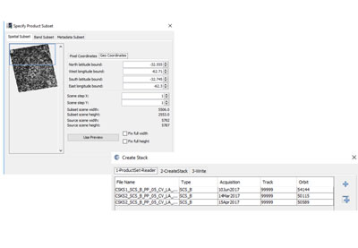
SNAP includes a number of tools for data processing, which were utilised during the project. The analysis workflow was similar for all the images.
First, the data were corrected radiometrically and geometrically. This included calibrating the images and applying functions such as multi-looking, speckle filtering and a range-doppler terrain correction.
Next, the corrected images were stacked on top of each other, before areas containing certain crops were identified. Using SNAP, virtual pins were placed on these locations.
The tool’s time series function was then used to extract temporal data on backscatter at the locations of the pins. This enabled the researchers to observe how backscatter changed over the course of the year at certain locations, as well as allowing comparisons of data between different fields.
More information on this activity – including step-by-step guides on how to use SNAP to process data – can be found on the course page.
In addition to scientific research, SNAP facilitates applications related to training and education, as well as operational services in many industries.
The tool includes an easy-to-use graphical interface and can also be operated from the command line, making it accessible to people with little experience of programming, as well as experts in data analysis.
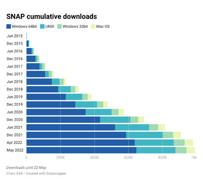
As a result, its user base is continuing to expand, with the tool reaching 1 million downloads earlier this year.
SNAP and other ESA toolboxes can be accessed via the Science Toolbox Exploitation Platform (STEP) website, which also hosts the SNAP discussion forum with more than 10,000 registered users, as well as documentation, tutorials, and third-party plugins.
SNAP is currently developed by a consortium that includes Brockmann Consult GmbH, CS France, CS Romania, SenSar and SkyWatch.