- All Categories (24)
- Data (2)
- News (9)
- Missions (4)
- Tools (2)
- Activities (5)
- Documents (2)
Data - Announcement of Opportunity (Restrained)

Announcement of Opportunity for S3VT (Sentinel-3 Validation Team)
In the framework of a Copernicus collaborative agreement ESA and EUMETSAT invite interested groups and individuals to support the Sentinel-3 Validation Team (S3VT).
News - Success Stories

Atmosphere-studying Odin mission enjoys ongoing success
More than two decades after it began operations, the Odin remote sensing satellite is continuing to make strong contributions to high-impact atmospheric science.
Activity - Projects

Auroral Electrojet and auroral Boundaries estimated from Swarm observations
In the Swarm-AEBS project, a set of new Swarm data products that characterise the auroral electrojets and auroral oval boundaries will be derived from Swarm magnetic field measurements.
Mission - Copernicus Sentinels

Copernicus Sentinel-3
Copernicus Sentinel-3 is an European Earth Observation satellite mission developed to support Copernicus ocean, land, atmospheric, emergency, security and cryospheric applications.
Activity - Projects
Dragon 2 Cooperation Programme
The Dragon 2 Programme focussed on the exploitation of ESA, ESA's Third Party Missions and Chinese Earth observation data for science and applications development in land, ocean and atmospheric applications.
Document - Proceedings

ERS-Envisat-symposium-proceedings.pdf
This document contains the proceedings of the ERS-Envisat Symposium, which took place in 2000.
Tools - Visualisation
EVDC Orbit Prediction Tool
The EVDC Orbit Prediction and Overpass Tool generates and visualises satellite's overpasses.
Mission - Earth Explorers

GOCE
ESA's Gravity field and Ocean Circulation Explorer (GOCE) mission mapped Earth's geoid very accurately, opening a window into Earth's interior structure as well as the currents circulating within the depths of its oceans.
Activity - General activities

GSCB and LTDP
The Copernicus programme is based on a fleet of European Earth observation satellites, built and operated by ESA, member states and commercial entities. Copernicus will also offer data from non-European satellites.
News - Success Stories

How Envisat helped to shape global understanding of Earth’s systems
Twenty years have passed since a ground-breaking European spacecraft designed to deliver unprecedented insight into the planet’s changing environment was lofted into orbit.
News - General News

New paper “Swarm Langmuir probes' data quality validation and future improvements” published
The paper “Swarm Langmuir probes' data quality validation and future improvements” by F. Catapano et al. has been published in the Geoscientific Instrumentation, Methods and Data Systems (GI) journal in March 2022.
Mission - Third Party Missions
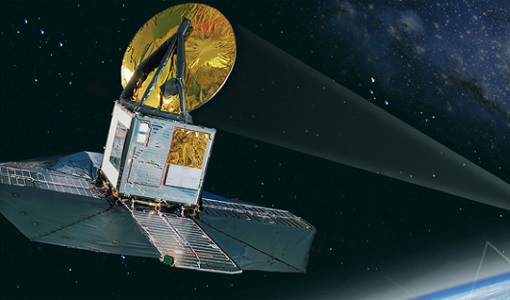
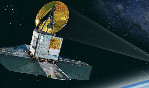
Odin
Odin is an atmosphere-studying satellite mission from Sweden, Canada, France and Finland.
News - Success Stories

Odin celebrates 18 years in orbit
ESA is proud to celebrate the excellent long-lasting performance of the Swedish-led Odin mission.
Data - Data Description
Odin SMR data products
The latest Odin Sub-Millimetre Radiometer (SMR) datasets have been generated by Chalmers University of Technology and Molflow within the Odin-SMR Recalibration and Harmonisation project, funded by the European Space Agency (ESA) to create a fully consistent and homogeneous dataset from the 20 years of satellite operations. The Odin satellite was launched in February 2001 as a joint undertaking between Sweden, Canada, France and Finland, and is part of the ESA Third Party Missions (TPM) programme since 2007. The complete Odin-SMR data archive was reprocessed applying a revised calibration scheme and upgraded algorithms. The Level 1b dataset is entirely reconsolidated, while Level 2 products are regenerated for the main mesospheric and stratospheric frequency modes (i.e., FM 01, 02, 08, 13, 14, 19, 21, 22, 24). The resulting dataset represents the first full-mission reprocessing campaign of the mission, which is still in operation.
Document - Product Document

Odin-Level-2-Aeronomy-data-products.pdf
This document outlines the format and storage of the various data products from the Level 2 processing software for the Odin mission.
Activity - Quality
Odin-SMR
ESA/SPPA took the initiative to support the reprocessing of all Odin-SMR measurements in order to create a fully consistent and homogeneous dataset of stratospheric species profiles.
News - Data Release news
Release of Odin SMR reprocessed data
Data from the Odin Sub-Millimetre Radiometer (SMR) reprocessing has been released to users and is now freely available.
News - Success Stories

Satellites track the health of the ozone layer
ESA’s Earth observation activities are contributing to international efforts to monitor and preserve the layer of stratospheric ozone that blankets the planet.
News - Infographics
Showcasing the atmosphere-studying Odin mission
Learn about the Odin mission in our new infographic.
News - Thematic area articles

Space data help to unravel the complexities of Earth’s atmosphere
As the impacts of the climate crisis intensify, scientists are using ESA’s Earth observation archives to investigate atmospheric processes and their influences on the planet’s changing environment.