- All Categories (101)
- Data (28)
- News (37)
- Missions (3)
- Events (10)
- Activities (1)
- Campaigns (8)
- Documents (14)
DATA
Discover and download the Earth observation data you need from the broad catalogue of missions the European Space Agency operate and support.
Data - Campaigns (Open)
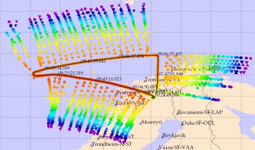
WALEX
The objective of (WALEX) was to collect valuable data to provide representative lidar measurements of water vapour and aerosol properties in different climatic zones.
Data - Campaigns (Open)
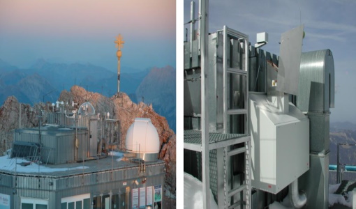
PremierEX
The campaign was based in the Arena Arctica in Kiruna (Sweden). The science campaign has addressed the science objectives and was part of the airborne campaign of the EU project RECONCILE.
Data - Fast Registration with immediate access (Open)
GOME Total Column Water Vapour Climate product
The GOME Total Column Water Vapour (TCWV) Climate product was generated by the Max Planck Institute for Chemistry (MPIC), and the German Aerospace Center (DLR) within the ESA GOME-Evolution project. It is a Level 3 type product containing homogenized time-series of the global distribution of TCWV spanning over more than two decades (1995-2015). The data is provided as single netCDF file, containing monthly mean TCWV (units kg/m2) with 1-degree resolution, and is based on measurements from the satellite instruments ERS-2 GOME, Envisat SCIAMACHY, and MetOp-A GOME-2. Details are available in the paper by Beirle et al, 2018. Please also consult the GOME TCWV Product Quality Readme file before using the data.
Data - Campaigns (Open)
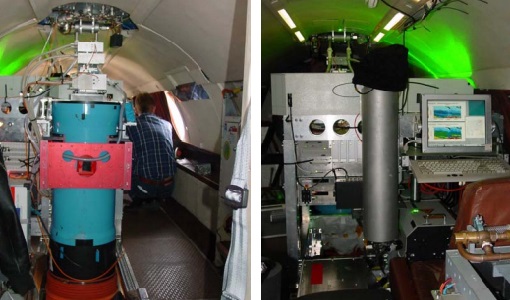
FIRMOS
In preparation of the Earth Explorer 9 FORUM mission, a new facility named FIRMOS (Far-Infrared Radiation Mobile Observation System) has been developed for field applications from both ground-based and airborne platforms to check with real measurements the sounding capability provided by FIR observations.
Data - Fast Registration with immediate access (Open)
ERS-2 GOME Total Column Amount of Trace Gases Product
GOME Level 2 products were generated by DLR on behalf of the European Space Agency, and are the end result of the Level 1 to 2 reprocessing campaign of GOME Level 1 version 4 data with Level 2 GOME Data Processor (GDP) version 5.0 (HDF-5 format). The GOME Level 2 data product comprises the product header, total column densities of ozone and nitrogen dioxide and their associated errors, cloud properties and selected geo-location information, diagnostics from the Level 1 to 2 algorithms and a small amount of statistical information.
Data - Fast Registration with immediate access (Open)
ERS-2 GOME Spectral Product L1
GOME Level 1 products contain Earthshine radiance at the Top of the Atmosphere and solar irradiance spectra. They were generated by DLR on behalf of the European Space Agency with Level 1 GOME Data Processor (GDP-L1) starting from the Extracted GOME Calibration (EGOC) Level 0 data files. Originally raw detector signals (binary Analog to Digital Converted units) of the science measurements plus calibration constants were provided (dataset version 4 and lower), but following the end of the operational phase of the ERS-2 mission (2 July 2011), as part of ESA's post-operational algorithm improvement activities (Coldewey-Egbers et al., 2018), the GOME Level 1 data type was entirely revised and a dataset of fully calibrated and ready to use data was generated with GOME processor version 5.1. The version 5.1 data bring relevant quality improvements for the revised calibration approach, compensating aging and instrument degradation, and provide enhanced accessibility. The version 5.1 data are in NetCDF format and differ fundamentally from the previous GOME Level 1 data, having the Envisat proprietary format and basically containing Level 1a data where a dedicated extraction software tool had to be applied by end user to obtain spectrally and radiometrically calibrated radiances (including the correction for polarisation, leakage current and stray light). Such calibrations are now applied to the version 5.1 L1b data product in the standard processing. Users of GOME Level 1 products are strongly recommended to migrate to the latest reprocessed dataset. Please consult the GOME Product Quality Readme file before using the data.
Data - Fast Registration with approval (Restrained)
ERS-1/2 ATSR Gridded Surface Temperature [AT1/AT2_NR__2P]
The Gridded Surface Temperature (GST) Product is the Level 2 full resolution geophysical product. The product contains gridded sea-surface temperature images using both nadir and dual view retrieval algorithms. The product includes pixel latitude/longitude positions, X/Y offset and the results of the cloud-clearing/land-flagging. It contains a single measurement data set the content of which is switchable, that is to say, the content of each pixel field will depend on the surface type. Specifically, the contents of the data fields will depend on the setting of the forward and nadir cloud flags and the land flag. The 3rd reprocessing of ATSR data was performed in 2013; the processing updates that have been put in place and the scientific improvements are outlined in full in the User Summary Note for the Third ERS ATSR Reprocessing.
Data - Fast Registration with approval (Restrained)
ERS-1/2 ATSR Gridded Brightness Temperature/Reflectance [AT1/AT2_TOA_1P]
The Gridded Brightness Temperature/Reflectance (GBTR) product contains top of atmosphere (TOA) brightness temperature (BT) values for the infra-red channels and reflectance values for the visible channels. Values for each channel and for the nadir and forward views occupy separate measurement data sets. Additional MDS contain cloud and land/sea flags and confidence flags for each image pixel. The 3rd reprocessing of ATSR data was performed in 2013; the processing updates that have been put in place and the scientific improvements are outlined in full in the User Summary Note for the Third ERS ATSR Reprocessing.
Data - Fast Registration with approval (Restrained)
ERS-1/2 ATSR Averaged Surface Temperature [AT1/AT2_AR__2P]
The Averaged Surface Temperature Product (AST) contains averaged geophysical data at two different resolutions, and with respect to two different averaging schemes: measurement data sets at resolutions of 0.5 by 0.5 degrees and 10 by 10 arcmin with respect to a latitude/longitude grid; other data sets contain data averaged over equal area cells of 50 by 50 km and 17 by 17 km aligned with the satellite ground track. Both top-of-atmosphere and surface data sets are provided. The surface temperature data sets provide, for sea cells, nadir and dual view sea surface temperatures, and for land cells, land surface temperature (currently 11 micron BT) and NDVI. Cloud data is also included. No ADS are included in the AST product; auxiliary data is contained within the MDS. The data sets of the AST product are arranged by surface type and resolution. The 3rd reprocessing of ATSR data was performed in 2013; the processing updates that have been put in place and the scientific improvements are outlined in full in the User Summary Note for the Third ERS ATSR Reprocessing.
Data - EO Sign In Authentication (Open)
Envisat MIPAS L2 - Temperature, pressure and atmospheric constituents profiles [MIPAS_2PS/2PE]
This MIPAS Level 2 data product describes localised vertical profiles of pressure, temperature and 21 target species (H2O, O3, HNO3, CH4, N2O, NO2, CFC-11, ClONO2, N2O5, CFC-12, COF2, CCL4, HCN, CFC-14, HCFC-22, C2H2, C2H6, COCl2, CH3Cl, OCS and HDO). It has a global coverage of Earth's stratosphere and mesosphere at all latitudes and longitudes. The vertical resolution of p, T and VMR profiles varies from 3 to 4 km, whereas the horizontal resolution is approximately 300 km to 500 km along track. This depends on the tangent height range and optical properties of the atmosphere. Auxiliary data include spectroscopic data, microwindows data, validation data, initial guess p, T and trace gas VMR profiles. The resolution range of the dataset is: 3 km (vertical) x 30 km (horizontal) at the tangent point. The latest reprocessed MIPAS Level 2 data (v8.22) is available as Standard products (MIPAS_2PS): A complete product containing 22 MIPAS L2 chemical species covering a single orbit and single species providing information generally needed by data users. Extended products (MIPAS_2PE): A complete product containing 22 MIPAS L2 chemical species covering a single orbit and single species intended for diagnostics and expert users who need complete information about the retrieval process. Both products are available in NetCDF format. Please refer to the MIPAS L2 v8.22 Product Quality Readme file for further details.
Data - EO Sign In Authentication (Open)

Envisat MIPAS L1 - Geo-located and calibrated atmospheric spectra [MIP_NL__1P]
This MIPAS Level 1 data product covers the geo-located, spectrally and radiometrically calibrated limb emission spectra in the 685-2410 cm-1 wave number range. It comprises 5 bands: 685-980 cm-1, 1010-1180 cm-1, 1205-1510 cm-1, 1560-1760 cm-1, 1810-2410 cm-1 and covers the following spatial ranges: Tangent height range: 5 to 170 km Pointing range: (azimuth pointing range relative to satellite velocity vector): 160° - 195° (rearward anti-flight direction); 80° - 110° (sideward anti-Sun direction). The instantaneous field of view (IFOV) is 0.05230 (elevation) x 0.5230 (azimuth)°. The length of measurement cell for an individual height step is approximately 300-500 km (dependent on tangent height and optical properties of the atmosphere). The spectral resolution spans from 0.030 to 0.035 cm-1, with a radiometric sensitivity of 4.2 to 50 nW / cm-1 / sr / cm2. The resolution range of the dataset is: 3 km (vertical) x 30 km (horizontal) at the tangent point. Please consult the Product Quality Readme file for MIPAS Level 1b IPF 8.03 before using the data.
Data - EO Sign In Authentication (Open)
Envisat MERIS Full Resolution - Level 2 [MER_FRS_2P/ME_2_FRG]
MERIS FR Level 2 is a Full-Resolution Geophysical product for Ocean, Land and Atmosphere. Each MERIS Level 2 geophysical product is derived from a MERIS Level 1 product and auxiliary parameter files specific to the MERIS Level 2 processing. The MERIS FR Level 2 product has Sentinel 3-like format starting from the 4th reprocessing data released to users in July 2020. The data package is composed of NetCDF 4 files containing instrumental and scientific measurements, and a Manifest file which contains metadata information related to the description of the product. A Level 2 product is composed of 64 measurement files containing: 13 files containing Water-leaving reflectance, 13 files containing Land surface reflectance and 13 files containing the TOA reflectance (for all bands except those dedicated to measurement of atmospheric gas - M11 and M15), and several files containing additional measurements on Ocean, Land and Atmospheric parameters and annotation. The Auxiliary data used are listed in the Manifest file associated to each product. The Level 2 FR product covers the complete instrument swath. The product duration is not fixed and it can span up to the time interval of the input Level 0/Level 1. Thus the estimated size of the Level 2 FR is dependent on the start/stop time of the acquired segment. During the Envisat mission, acquisition of MERIS Full Resolution data was subject to dedicated planning based on on-demand ordering and coverage of specific areas according to operational recommendations and considerations. See yearly and global density maps to get a better overview of the MERIS FR coverage.
Data - EO Sign In Authentication (Open)
Envisat MERIS Full Resolution - Level 1 [MER_FRS_1P/ME_1_FRG]
The MERIS Level 1 Full Resolution (FR) product contains the Top of Atmosphere (TOA) upwelling spectral radiance measurements. The in-band reference irradiances for the 15 MERIS bands are computed by averaging the in-band solar irradiance of each pixel. The in-band solar irradiance of each pixel is computed by integrating the reference solar spectrum with the band-pass of each pixel. The MERIS FR Level 1 product has Sentinel 3-like format starting from the 4th reprocessing data released to users in July 2020. Each measurement and annotation data file is in NetCDF 4. The Level 1 product is composed of 22 data files: 15 files containing radiances at each band (one band per file), accompanied by the associated error estimates, and 7 annotation data files. The 15 sun spectral flux values provided in the instrument data file of the Level 1 products are the in-band reference irradiances adjusted for the Earth-sun distance at the time of measurement. The band-pass of each pixel is derived from on-ground and in-flight characterisation via an instrument model. The values "Band wavelength" and "Bandwidth" provided in the Manifest file of the Level 1b products are the averaged band-pass of each pixel over the instrument field of view. Auxiliary data are also listed in the Manifest file associated to each product. The Level 1 FR product covers the complete instrument swath. The product duration is not fixed and it can span up to the time interval of the input Level 0 (for a maximum of 20 minutes). Thus the estimated size of the Level 1 FR is dependent on the start/stop time of the acquired segment. During the Envisat mission, acquisition of MERIS Full Resolution data was subject to dedicated planning based on on-demand ordering and coverage of specific areas according to operational recommendations and considerations. See yearly and global density maps to get a better overview of the MERIS FR coverage.
Data - EO Sign In Authentication (Open)

EarthCARE Orbit Data
EarthCARE data products encompass essential supporting auxiliary (AUX) and orbit data critical for accurate sensor data processing and analysis. Orbit data consists of on-board satellite data and orbital information predicted or determined by the Flight Operations Segment (FOS). For EarthCARE, this includes Reconstructed Orbit and Attitude Files, which provide detailed satellite positioning and orientation information. The integration of AUX and orbit data into EarthCARE's data processing workflow ensures the production of high-quality, scientifically valuable datasets for atmospheric research, climate modelling, and environmental monitoring.
Data - Restrained Access (Restrained)

EarthCARE L1 Products for Cal/Val Users
This EarthCARE collection is restrained, and contains the following data products: Level 1B: Fully Calibrated and Geolocated Instrument Science Measurements Level 1b data represents the fully processed, calibrated, and geolocated measurements from EarthCARE's instruments. Each measurement is aligned with the native instrument grid. For the Broadband Radiometer (BBR), measurements are also spatially integrated to various ground pixel sizes. Level 1C (MSI only): MSI Level 1b Data Interpolated to a Common Spatial Grid Specifically for the Multi-Spectral Imager (MSI), Level 1c data involves interpolating Level 1b measurements onto a standardised spatial grid that is consistent across all MSI bands. This grid closely matches the spacing used in MSI Level 1b data. Level 1D: Joint Standard Grid (JSG) for all instruments with ECMWF Meteorological Fields. Level 1d data provides a spatial grid to enable easy collocation and synergistic use of the data from all EarthCARE instruments, named the "joint standard grid." Additionally, this level incorporates ECMWF (European Centre for Medium-Range Weather Forecasts) meteorological fields limited to the EarthCARE swath, enabling comprehensive analysis and modelling of atmospheric conditions within the satellite's coverage area.
Data - EO Sign In Authentication (Open)

EarthCARE L1 Products
This EarthCARE collection contains the following data products: Level 1b: Fully Calibrated and Geolocated Instrument Science Measurements Level 1b data represents the fully processed, calibrated, and geolocated measurements from EarthCARE's instruments. Each measurement is aligned with the native instrument grid. For the Broadband Radiometer (BBR), measurements are also spatially integrated to various ground pixel sizes. Level 1c (MSI only): MSI Level 1b Data Interpolated to a Common Spatial Grid Specifically for the Multi-Spectral Imager (MSI), Level 1c data involves interpolating Level 1b measurements onto a standardised spatial grid that is consistent across all MSI bands. This grid closely matches the spacing used in MSI Level 1b data. Level 1d: Joint Standard Grid (JSG) for all instruments with ECMWF Meteorological Fields. Level 1d data provides a spatial grid to enable easy collocation and synergistic use of the data from all EarthCARE instruments, named the "joint standard grid." Additionally, this level incorporates ECMWF (European Centre for Medium-Range Weather Forecasts) meteorological fields limited to the EarthCARE swath, enabling comprehensive analysis and modelling of atmospheric conditions within the satellite's coverage area. CPR level 1b: C-NOM products is generated and provided by JAXA. This product is used as input, in combination with the X-MET aux file, for different processors in the EarthCARE production chain. AUX_MET_1D: meteorological analysis and forecast fields X-MET provided by ECMWF. This product is used as input, in combination with the C-NOM product, for different processors in the EarthCARE production chain.
Data - Restrained Access (Restrained)

EarthCARE L0 and L1 Products for the Commissioning Team
This EarthCARE collection for the Commissioning Team contains the following data products: Level 0: Annotated Raw Instrument Source Packets These packets contain unprocessed data as generated by EarthCARE's instruments, annotated with basic metadata in front of each packet Level 1b: Fully Calibrated and Geolocated Instrument Measurements Level 1b products are fully processed, calibrated, and geolocated measurements from EarthCARE's instruments. Each measurement is aligned with the native instrument grid. For the Broadband Radiometer (BBR), measurements are also spatially integrated to various ground pixel sizes. Level 1C (MSI only): MSI Level 1b Data Interpolated to a Common Spatial Grid Specifically for the Multi-Spectral Imager (MSI), Level 1c data involves interpolating Level 1b measurements onto a standardised spatial grid that is consistent across all MSI bands. This grid closely matches the spacing used in MSI Level 1b data. Level 1D: Joint Standard Grid (JSG) for all Instruments and ECMWF Meteorological Fields Level 1d data provide a spatial grid to enable easy collocation and synergistic use of the data from all EarthCARE instruments, named the "joint standard grid." Additionally, this level incorporates ECMWF (European Centre for Medium-Range Weather Forecasts) meteorological fields limited to the EarthCARE swath, enabling comprehensive analysis and modelling of atmospheric conditions within the satellite's coverage area.
Data - Restrained Access (Restrained)

EarthCARE JAXA L2 Products for the Commissioning Team
This EarthCARE collection contains the following data products: Level 2a: Single-Instrument Geophysical Products These products are derived from individual instrument data onboard EarthCARE. They provide detailed geophysical parameters and properties specific to each instrument's capabilities for example cloud and aerosol properties derived solely from radar or lidar measurements, offering high-resolution insights into atmospheric phenomena. Level 2b: Synergistic Geophysical Products Level 2b products leverage data from multiple EarthCARE instruments to generate comprehensive, synergistic geophysical datasets. By combining measurements from instruments like radar, lidar, and radiometers, these products offer a more integrated view of cloud-aerosol interactions and atmospheric dynamics. Synergistic products provide enhanced accuracy and depth compared to single-instrument outputs, enabling detailed studies of complex atmospheric processes.
Data - Restrained Access (Restrained)
EarthCARE JAXA L2 Products for Cal/Val Users
This EarthCARE collection is restrained, and contains the following data products: Level 2a: Single-Instrument Geophysical Products These products are derived from individual instrument data onboard EarthCARE. They provide detailed geophysical parameters and properties specific to each instrument's capabilities for example cloud and aerosol properties derived solely from radar or lidar measurements, offering high-resolution insights into atmospheric phenomena. Level 2b: Synergistic Geophysical Products Level 2b products leverage data from multiple EarthCARE instruments to generate comprehensive, synergistic geophysical datasets. By combining measurements from instruments like radar, lidar, and radiometers, these products offer a more integrated view of cloud-aerosol interactions and atmospheric dynamics. Synergistic products provide enhanced accuracy and depth compared to single-instrument outputs, enabling detailed studies of complex atmospheric processes.
Data - EO Sign In Authentication (Open)
EarthCARE JAXA L2 Products
This EarthCARE collection contains the following data products: Level 2a: Single-Instrument Geophysical Products These products are derived from individual instrument data onboard EarthCARE. They provide detailed geophysical parameters and properties specific to each instrument's capabilities for example cloud and aerosol properties derived solely from radar or lidar measurements, offering high-resolution insights into atmospheric phenomena. Level 2b: Synergistic Geophysical Products Level 2b products leverage data from multiple EarthCARE instruments to generate comprehensive, synergistic geophysical datasets. By combining measurements from instruments like radar, lidar, and radiometers, these products offer a more integrated view of cloud-aerosol interactions and atmospheric dynamics. Synergistic products provide enhanced accuracy and depth compared to single-instrument outputs, enabling detailed studies of complex atmospheric processes.