- All Categories (58)
- Data (2)
- News (18)
- Missions (1)
- Events (9)
- Tools (1)
- Activities (2)
- Campaigns (13)
- Documents (12)
News - Events and Proceedings
Featuring the power of Earth observation data at EGU
The European Geosciences Union General Assembly 2024 brings together geoscientists from all over the world, aiming to provide a forum where scientists and early career researchers can present their work and discuss their ideas with experts, in all fields of geoscience.
News - General News
Go-to guide to Third Party Mission data offering
ESA’s latest Third Party Missions Data Access Guide has been published, providing technical details and information on available data collections for all current or past Third Party Missions.
News - Success Stories
Trailblazing ERS-2 mission enables climate change applications
As ESA’s ERS-2 satellite approaches Earth’s atmosphere for reentry, it’s time to reflect on the mission’s great achievements in powering climate-related applications.
News - Thematic area articles
How to use space data to probe humankind’s ancient past
Data disseminated by ESA’s Third Party Missions (TPM) programme are enabling archaeological investigations that could help to unravel the mysteries of past societies and cultures.
Document - Newsletter

Earth Online Newsletter 01 December 2023
This issue of the Earth Online Newsletter covers a selection of the latest news and events from ESA.
News - Success Stories
ESA missions help to reveal worldwide lake water loss trend
Climate change, human consumption and sedimentation are depleting more than half of the world’s biggest lakes of water, according to a ground-breaking analysis that drew on three decades of satellite data.
News - Thematic area articles
Remote sensing data map impacts of natural hazards
As climate change increases the frequency and severity of natural disasters, remote sensing data can warn about extreme events and help tackle emergency situations.
News - Events and Proceedings
Scientists to showcase value of Earth observation data at EGU
Remote sensing scientists are getting ready to present innovative and exciting applications of satellite data at the European Geosciences Union general assembly which will take place from 24 to 28 April in Vienna, Austria.
News - General News
ESA's excellent Earth Explorer missions extended to 2025
Since 2009, ESA’s Earth Explorer missions have pioneered breakthrough technologies and transformed our understanding of Earth’s system, from its core to the outer stretches of the atmosphere.
News - Thematic area articles
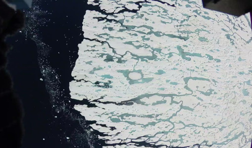
Monitoring water on Earth's surface
ESA's Earth observation satellites are playing a leading role in furthering our understanding of how Earth's terrestrial hydrosphere is being influenced by humankind.
Event - Conference

Living Planet Symposium 2022
Learn about the 2022 edition of ESA's Living Planet Symposium.
News - Data Release news

Two new ESA archive collections have been opened for PlanetScope and SkySat
PlanetScope ESA archive and SkySat ESA archive collections are available through ESA’s Third Party Missions programme via Fast Approval Registration.
Data - Fast Registration with approval (Restrained)
SkySat ESA archive
The SkySat ESA archive collection consists of SkySat products requested by ESA supported projects over their areas of interest around the world and that ESA collected over the years. The dataset regularly grows as ESA collects new products. Two different product types are offered, Ground Sampling Distance at nadir up to 65 cm for panchromatic and up to 0.8m for multi-spectral. EO-SIP Product Type Product Description Content SSC_DEF_SC Basic and Ortho scene Level 1B 4-bands Analytic /DN Basic scene Level 1B 4-bands Panchromatic /DN Basic scene Level 1A 1-band Panchromatic DN Pre Sup resolution Basic scene Level 3B 3-bands Visual Ortho Scene Level 3B 4-bands Pansharpened Multispectral Ortho Scene Level 3B 4-bands Analytic/DN/SR Ortho Scene Level 3B 1-band Panchromatic /DN Ortho Scene SSC_DEF_CO Ortho Collect Visual 3-band Pansharpened Image Multispectral 4-band Pansharpened Image Multispectral 4-band Analytic/DN/SR Image (B, G, R, N) 1-band Panchromatic Image The Basic Scene product is uncalibrated, not radiometrically corrected for atmosphere or for any geometric distortions inherent in the imaging process: Analytic - unorthorectified, radiometrically corrected, multispectral BGRN Analytic DN - unorthorectified, multispectral BGRN Panchromatic - unorthorectified, radiometrically corrected, panchromatic (PAN) Panchromatic DN - unorthorectified, panchromatic (PAN) L1A Panchromatic DN - unorthorectified, pre-super resolution, panchromatic (PAN) The Ortho Scene product is sensor and geometrically corrected, and is projected to a cartographic map projection: Visual - orthorectified, pansharpened, and colour-corrected (using a colour curve) 3-band RGB Imagery Pansharpened Multispectral - orthorectified, pansharpened 4-band BGRN Imagery Analytic SR - orthorectified, multispectral BGRN. Atmospherically corrected Surface Reflectance product. Analytic - orthorectified, multispectral BGRN. Radiometric corrections applied to correct for any sensor artifacts and transformation to top-of-atmosphere radiance. Analytic DN - orthorectified, multispectral BGRN, uncalibrated digital number imagery product Radiometric corrections applied to correct for any sensor artifacts Panchromatic - orthorectified, radiometrically correct, panchromatic (PAN) Panchromatic DN - orthorectified, panchromatic (PAN), uncalibrated digital number imagery product The Ortho Collect product is created by composing SkySat Ortho Scenes along an imaging strip. The product may contain artifacts resulting from the composing process, particular offsets in areas of stitched source scenes. Spatial coverage: Check the spatial coverage of the collection on a map available on the Third Party Missions Dissemination Service. As per ESA policy, very high-resolution imagery of conflict areas cannot be provided.
News - Thematic area articles

Transforming space data into climate action
ESA’s Earth observation activities are playing a key role in the revitalised global drive to combat climate change.
Campaign
CryoVEx ICESat-2 Summer 2019
The ESA CryoVEx/ICESat‐2 summer campaign 2019 is an add‐on to the campaign carried out in the spring 2019, which did not cover all the flights that were planned due to weather obstacles.
Campaign

CryoVEx/ICESat-2 Spring 2019
The ESA Spring CryoVEx/ICESat-2 campaign 2019 was the first CryoVEx campaign since the launch of NASA ICESat-2 in September 2018, and aimed at cross-validating ESA CryoSat-2 and NASA ICESat-2 missions over sea ice and land ice in the Arctic.
News - Data Release news

PlanetScope and Skysat data available through ESA’s Third Party Missions Programme
Through ESA’s Third Party Missions Programme, researchers, scientists and companies from around the world can apply to access Planet’s high-frequency, high-resolution satellite data for non-commercial use.
News - Success Stories

Predicting crop yield using Planet data
The world’s population continues to grow, while the climate crisis is raising Earth’s temperatures and increasing the likelihood of extreme weather events – all of which affect food security.
News - Infographics

PlanetScope and SkySat - The high-resolution nanosatellite constellation
Find out more about the PlanetScope and SkySat missions in our new infographic.
News - Data Release news
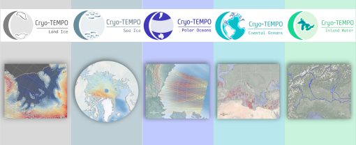
New CryoSat-2 Thematic Products Now Available
As of January 2022, ESA has started releasing new CryoSat-2 Thematic Products, dedicated to five distinct areas: Sea Ice, Land Ice, Polar Oceans, Coastal Oceans and Inland Waters.