- SPOT
- Objectives
SPOT Objectives
Series Objectives
Data acquired by the SPOT satellites has many operational applications ranging from Earth sciences to economic planning and decision making, including vegetation monitoring, agriculture, forestry, soils, geology, erosion, oil and mineral exploration, water resource management, urban and rural planning, civil engineering, development projects and environmental monitoring.
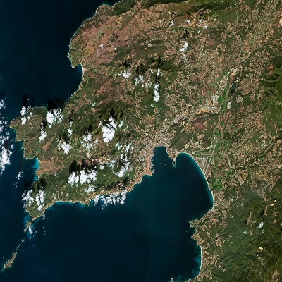
SPOT supplies high-resolution, wide-area optical imagery and sensory data through the differing imagers and sensors of each craft throughout their operational lifespans. With a focus on mapping, digital terrain modelling, and environmental monitoring, the SPOT satellite series offers acquisition and daily revisit capacity for anywhere in the world.
SPOT produces two high resolution optical images:
- The multispectral mode is in the red, green and infrared bands of the electromagnetic spectrum.
- The panchromatic mode is a single wide band in the visible part of the spectrum with higher resolution.
A SPOT satellite acquisition covers large areas in a single pass at resolutions up to 1.5 m. Such precise coverage is ideal for applications at national and regional scales from 1:250,000 to 1:15,000.
The SPOT archive contains more than 100 billion square kilometres of imaging data acquired since 1986, a unique database for temporal evolution monitoring.
SPOT key features:
- Stereo and tristereo capacity
- Ideal for 1:25,000 topographic mapping: Feature extraction (2D and 3D stereo plotting, geometric accuracy down to 1.2 m CE90, elevation and contour lines)
- Daily revisit anywhere by SPOT 6 or 7
- Maximum acquisition capacity of 3 million km² per day per satellite