- News & Events
- 1st International GOCE User Wo...
1st International GOCE User Workshop
23-Apr - 24-Apr 2001
Noordwijk, The Netherlands

This workshop provided a forum for presenting and discussing the development, use and exploitation of GOCE Level 2 (global and regional) geoid products, and of Level 3 (science and application) data products. The technical and programmatic status of the GOCE Project was also provided.
The workshop was open to all scientists with an interest in exploiting GOCE gravity data products. Preparations were underway in the international scientific community for exploitation of GOCE gravity data along with other geodetic and oceanographic data sources. These include use of the GOCE gravity field or geoid in various scientific applications. Moreover, GOCE data could be compared and/or combined with other gravity data derived from the ongoing German Challenging Minisatellite Payload mission (CHAMP) for geoscience and application or the US-German Gravity Recovery and Climate Experiment (GRACE) mission (launched in 2002).
Resulting high-precision geoid data are expected to have an impact in Oceanography, Solid-Earth Physics, Geodesy, Glaciology and Climate change research. The goal of the GOCE mission was to deliver a high-precision and high resolution global gravity field model, as well as global gridded geoid heights and gravity anomalies to the scientific community.
ESA was coordinating efforts to produce validated high-resolution gravity and geoid models. Various groups and consortia throughout Europe had also expressed an interest in development of either level 2 or 3 products, and in pursuing GOCE-related research. This workshop provided an opportunity to publicise these higher-level data processing plans and to coordinate such activities.
Mission Background
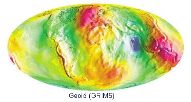
ESA's Gravity Field and Steady-State Ocean Circulation Explorer (GOCE) mission, launched in the 2009, was a geodetic mission exploiting a unique measurement technique to recover precision data on Earth's gravity field. In particular, GOCE recovered high spatial resolution (~ 100 km) gravity field data, and provided information with which to advance knowledge of the Earth's reference equipotential surface, the geoid.
Workshop Proceedings
Plenary Session
- Opening Welcome: M.R. Drinkwater
- Implications of GOCE Gravity Field/Geoid in Geodesy - H. Suenkel
- The GOCE Mission (Payload/Spacecraft) - A. Popescu
- What will GOCE do for Science (at Level 2)?
- Impact on Oceanography - J. Johannessen
- Impact on Solid-Earth Physics - R. Sabadini
European & National User Group Activities
- The European GOCE Gravity Consortium - G. Balmino
- GOCE-Italy - F. Sanso et al.
- GOCE-Germany (Geodesy Activities) - N. Sneeuw et al.
- GOCE-Norway (Geophysics and Geodesy) - R. Haagmans et al.
National User Group Activities (continued)
- GOCE-Germany (Oceanography) - J. Schroeter et al.
- GOCE-UK (Oceanography) - K. Haines et al.
- GOCE-Netherlands (Oceanography) - P.J. van Leeuwen et al.
Mission Synergy & Calibration/Validation
- Processing & CHAMP/GRACE/GOCE Product Synergy - T. Gruber
- Aspects of GOCE Calibration - R. Koop et al.
- External Geophysical Cal/Val - E. Schrama
- Validation of GOCE and GOCE/GRACE Data Products, Prelaunch Support and Science Studies - C.K. Shum et al.
Gravity Field Recovery
- Time-wise Determination of the Earth's Gravity Field... - P. Ditmar & R. Klees
- Gradiometric Data Analysis Using Icosahedral Grids; - J. Kusche et al.
- On the Regularisation Problem in Gradiometric Data Analysis from GOCE - J. Kusche et al.
- Assessment of Gravity Field Solution Strategies - W.-D. Schuh et al.
- Comparative Analysis of GOCE Simulated Data - J. Zielinski et al.
Data Combination Issues
- Covering the GOCE Mission Polar Gaps Using Gradients and Ground Gravity - C. Tscherning
- Multiscale Modelling of GOCE Data Products - W. Freeden
Level 3 Data Applications: Post-Glacial Isostatic Adjustment
- Glacial-Isostatic Adjustment and Sea-Level Studies - L. Vermeersen et al.
Level 3 Data Applications: Oceanography
- Mean Ocean Dynamic Topography - P-Y. LeTraon et al.
- Geoid Scales from Altimetry and In Situ Observations - H. Snaith et al.
- North Atlantic Dynamic Topography - H.P. Plag
Workshop Wrap Up
- Summary of Workshop Discussion Items &
Sequence of Activities with respect to Key GOCE Mission Operations Phases - Preliminary Technical Note on GOCE Data Products for the User Community (courtesy P. Visser)
Further information
Find out about other workshops in this series: