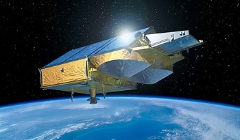
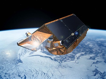
- CryoSat
- Mission
- CryoSat Overview
CryoSat Overview
Mission Background
CryoSat's radar altimeter is based on heritage from existing instruments, but with several major enhancements designed to improve measurements of icy surfaces. Because of its operations in SAR and Interferometric modes, the altimeter is called SIRAL (SAR Interferometric Radar Altimeter). CryoSat orbits at an unusually high inclination, reaching latitudes of 88° North and South.
CryoSat determines the thickness of floating sea ice by measuring the freeboard of ice floes; that is the height by which the ice extends above the water surface. This technique has been demonstrated with the ERS-1 radar altimeter, but this instrument, as with all conventional radar altimeters, is hampered by its relatively low spatial resolution of about 5 km. CryoSat achieves improved spatial resolution of 250 m in the along-track direction using the Synthetic Aperture technique.
The first returning energy in the radar echo comes from the part of the Earth's surface closest to the satellite. Over sea ice (and ocean) this point is directly below the satellite, but on sloping surfaces, such as those found around the edges of ice sheets, this nearest point can be anywhere. CryoSat is able to pin down the location of the echo in the fore- and aft-direction by using its SAR capability, but to resolve left and right an additional feature is needed. Over these sloping surfaces, CryoSat operates in SAR-Interferometry mode, which provides the key measurements of the angle of arrival and thus the pin-pointed source of the echo.
CryoSat was the third Earth Explorer mission to be launched. The Earth Explorers are specialised missions dedicated to observing different aspects of the planet and our environment. A secondary aim of the programme is to understand how these aspects interact with one another.
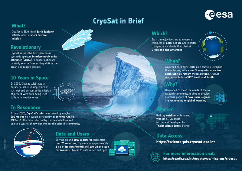
CryoSat is the first ESA mission dedicated to study the Earth's cryosphere, but during the course of the mission applications for oceanography have been discovered.
This satellite replaced the original CryoSat which was lost due to a launch failure in October 2005.
CryoSat Infographic
To mark the 10th anniversary of CryoSat in 2020, an infographic was produced to highlight the mission and its many achievements:
Satellite Design
CryoSat is a satellite with a single primary mission objective – therefore, the selection of its orbit and basic characteristics has been entirely driven by the scientific requirements.
Unlike most remote sensing satellites, CryoSat's orbit is not Sun-synchronous, but will go through frequent eclipse phases. This has presented some challenges in the satellite design; all parts will at some time be exposed to the full heating power of the Sun, while at other times parts of the satellite will be in permanent shadow for weeks on end.
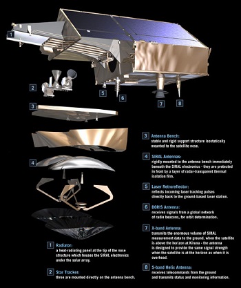
CryoSat does not have any deployable solar panels; in fact the satellite has no moving parts at all, except for some valves in the propulsion system. This has enabled a very significant cost saving, but does pose some problems for the provision of adequate solar power in CryoSat's unusual orbit. The solar panels are fixed to the satellite body, forming a 'roof' at a carefully optimised angle, which provides adequate power under all orbital conditions and still fits within the launch vehicle.
The other area that receives particular attention has been the mounting of the two SIRAL antennas. The baseline on which the SIRAL antennas were mounted has to be completely stable and has to ensure minimal thermal expansion. Any distortion will lead to errors in the assumed location of the echo and hence the elevation of the surface of the ice. The challenge has been met by designing the structure to be intrinsically stable and providing auxiliary attitude measurement sensors, in the form of star trackers, mounted directly onto the antenna bench structure.
The satellite is 4.6 m x 2.34 m x 2.2 m in dimension and has a mass of 725 kg.
Mission Operations
CryoSat flies in a non sun-synchronous low Earth Orbit at 92° inclination and 717 km mean altitude. The satellite has a 369 day repeat cycle (with a 30 day sub-cycle).
The mission has a single ground station at Kiruna in Sweden, which is responsible for payload data processing.
The flight operations are conducted at ESOC (European Space Operations Centre) in Germany.
Data is locally archived with precision processing one month after the delivery of precision orbits from the DORIS ground segment (under CNES responsibility).
User services and mission planning are coordinated at ESRIN, in Italy.
Track the CryoSat mission in orbit in real time using the ESTRACKnow tool.
| Power | 2x GaAs body-mounted solar arrays, with 800 W each at normal solar incidence. 78 Ah Li-ion battery. |
| TM-band | X-band data downlink: 100 Mbps at 8.100 GHz S-band TTC link: 2 kbps uplink, 16 kbps downlink |
| Data Volume | 1 internally redundant Solid-State Recorder, total capacity 256 Gbits |
Ground Segment
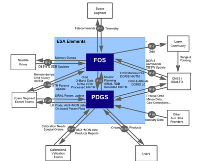
The CryoSat ground segment is currently organised around a single ESA ground station, located in Kiruna in northern Sweden. This is where contact is established with the satellite, for about 10 minutes 11 times per day, during which commands are sent to the satellite, and data downloaded over an X-band microwave link.
Mission planning, however, is performed in ESA-ESRIN for what concerns the payload part (mainly the instrument activity planning) and in ESA-ESOC for what concerns the platform part (mainly orbit maintenance through manoeuvres). The detail plan is uploaded weekly to the satellite from Kiruna-Salmijarvi.
It is worth noting that the CryoSat instrument activity is mostly repetitive, and is based on ground topology (ice boundaries evolving through the year) with a few specific user demands for Near Real Time applications, therefore it is subject to periodic modifications which follow the seasonal cycle.
The large amount of data received from the payload, and in particular from the altimeter, is processed at Kiruna-Esrange. Data products at Level-1b (radar echoes geo-located and corrected for instrument features) and Level-2 (ground elevation and ice freeboard, corrected for atmospheric and geo-physical effects) are produced by ESA systematically, based on the repetitive data acquisition planned above. There is no 'on-demand' data processing in the routine data production; however, provision is made for troubleshooting needs.
All external auxiliary data needed for the data processing, and in particular the Precise Orbit data is received from the SSALTO centre operated by CNES in Toulouse, with one exception - dynamic sea-ice concentration which is received from UCL in London.
Data are routinely distributed to users via the internet. Use of high-speed infrastructure and network services are also used to the maximum extent feasible.
Related Links
- CryoSat Mission and Data description document
- CryoSat on the eoPortal*
- CryoSat Operational Polar Monitoring*
- CPOM*
- Earth Observation Principal Investigators (EOPI) community
- ICESat Mission*
- International DORIS Service (IDS)*
- NOAA CryoSat IGDR*
- National Snow and Ice Data Center (NSIDC)*
- Sea-ice data products (AWI)*
*The information provided is sourced and updated by external entities. For further details, please consult our Terms and Conditions page.
Social and multimedia links
- Follow us on X (formerly known as Twitter)
- CryoSat on the eoPortal
- Arctic Campaign Blog
- CryoSat iPhone app
- CryoSat iPad app
- CryoSat app for Android
Frequently Asked Questions
What is SIRAL and what does it do?
How is the baseline orientation measured?
How is the position of the CryoSat satellite measured?
What is the orbit repeat cycle?
If this FAQ does not answer my question, what should I do?
Where can I access quality and technical information about the CryoSat products?
How can I be informed about the latest operational news on the mission?
Q: What is CryoSat?
A: CryoSat is an altimetry satellite built by the European Space Agency (ESA) and dedicated to polar observation. The mission aims to determine variations in the extent and thickness of the Earth's continental ice sheets and polar sea ice, and to test the prediction of global ice loss due to global warming.
Launched in April 2010, CryoSat is Europe's first dedicated ice mission. It provides multi-year elevation data at latitudes never reached before by a satellite altimeter. CryoSat carries sophisticated technologies to measure changes at the margins of the vast ice sheets that cover Greenland and Antarctica and marine ice floating in the polar oceans. By accurately measuring thickness change in both types of ice, CryoSat will provide information to contribute to a better understanding of the role ice plays in the Earth system.
Alongside CryoSat's contribution to the sea ice and land ice communities, CryoSat data is used widely by a number of other scientific communities including meteorology, oceanography, marine gravity, coastal zones and hydrology.
For more information, please visit the Living Planet website. A CryoSat e-book is also available to download.
Q: What is SIRAL and what does it do?
A: SIRAL stands for Synthetic Aperture Interferometric Radar Altimeter and is the primary instrument on-board CryoSat. It has extended capabilities to meet the measurement requirements for ice-sheet elevation and sea-ice freeboard.
Derived from the well-known Poseidon ocean altimeter on the Jason satellite, SIRAL is a very compact assembly, weighing just 90 kilograms. It combines three measurement modes to determine the topography of land and sea ice masses, as well as ice floes and significant elevation transitions, especially between land and ice fields:
- Over the oceans and ice sheet interiors, CryoSat operates like a traditional radar altimeter in Low Resolution Mode (LRM)
- Over sea ice, coherently transmitted echoes are combined via Synthetic Aperture Radar (SAR) processing, to reduce the surface footprint and enable CryoSat to map smaller ice floes. This mode is used to obtain high-resolution measurements of floating sea ice, enabling the indirect measurement of ea ice thickness.
- CryoSat's most advanced mode is used around the ice sheet margins and over mountain glaciers. Here, the altimeter performs synthetic aperture processing and uses a second antenna as an interferometer to determine the across-track angle to the earliest radar returns. This mode (SAR Interrfometry (SARIn)) provides the exact surface location being measured when the surface is sloping and can be used to study steep and mountainous terrains, such as the very active areas located at the junction of the ice sheet and the Antarctic continent, or Greenland.
Q: How is the baseline orientation measured?
A: Knowledge of the precise orientation of the baseline and the two receiving antennas is essential for the success of the mission. CryoSat measures this baseline orientation using the position of the stars in the sky. Three star trackers are mounted on the support structure for the antennas. Each contains a camera, which takes up to five pictures per second. The images are analysed by a built-in computer and compared to a catalogue of star positions.
Baseline parameters are available in the Baseline C Ice products. The L1B products contain values for the interferometric baseline vector and real beam direction vector. Both L1B and L2 products contain values for the antenna bench angles (Roll, Pitch and Yaw), which are used to calculate the mispointing angle in the L2 products. This is the angle between the antenna pointing (direction of beam) and the nadir direction, and nominally this should be zero.
Q: How is the position of the CryoSat satellite measured?
A: In order to accurately measure the position of the satellite, CryoSat carries some additional specific equipment:
- The Doppler Orbit and Radio-positioning Integration by Satellite (DORIS) radio receiver detects and measures the Doppler shift of signals broadcast from a network of over 50 radio beacons spread around the world
- A small laser retro-reflector reflects light back in exactly the direction it came from. A global network of laser tracking stations fire short laser pulses at CryoSat and record the time interval before the pulse is reflected back. This provides independent reference measurements of CryoSat's position.
- The International Laser Ranging Service (ILRS) provides tracking from its global network of laser ranging stations to support the project
Q: What orbit does CryoSat use?
A: CryoSat orbits at an unusually high inclination, of about 92 degrees. The orbit is not sun-synchronous and consequently the orbital plane rotates with respect to the sun direction, at an altitude of 717 kilometres.
Q: What is the orbit repeat cycle?
A: The repeat cycle for CryoSat is 369 days and 5344 orbits. This cycle provides full coverage of the earth and the cycle number is provided in the CryoSat product headers. The repeat cycle is made up of approximately 30-day sub-cycles, defined and used primarily for statistic and quality reporting.
Q: If this FAQ does not answer my question, what should I do?
A: All queries regarding CryoSat and SIRAL should be directed to ESA's User Services Portal.
Q: Where can I access quality and technical information about the CryoSat Products?
A: Users can access quality information about the CryoSat data products on the SIRAL Quality Control Reports page.
Q: How can I be informed about the latest operational news on the mission?
A: CryoSat operational news is regularly posted on this website and follow us @esa_cryosat on X (formerly known as Twitter).