earth online
  • Explore Missions
    • Earth Explorers
    • Heritage Missions
    • Third Party Missions
  • Explore Data
    • All Data
    • Open Data
    • Announcement of Opportunity
    • Project Proposal
    • Sample Data
    • Dashboard
  • Explore Tools
    • Analysis Tools
    • Processing Tools
    • Visualisation Tools
    • Catalogues
    • Apps
  • Explore News & Events
    • All News
    • Data Release News
    • Maintenance News
    • Operational News
    • All Events
    • Events Updates
    • Workshop
    • Conference
  • Explore Learn & Discover
    • Data Application Articles
    • Spotlight on EO Community
    • Gallery
    • FAQ
    • Success Stories
    • Infographics
    • Quality Reports Advanced Search
  • SEE ALL
  • SPOT
  • SPOT
  • Missions
    • SPOT 1
    • SPOT 2
    • SPOT 3
    • SPOT 4
    • SPOT 5
    • SPOT 6
    • SPOT 7
  • Overview
  • Objectives
  • SPOT
  • Missions
    • SPOT 1
    • SPOT 2
    • SPOT 3
    • SPOT 4
    • SPOT 5
    • SPOT 6
    • SPOT 7
  • Overview
  • Objectives
More

    SPOT

    The SPOT (from French "Satellite pour l'Observation de la Terre") series of missions has been supplying high-resolution, wide-area optical imagery since 1986.

    The SPOT (from French "Satellite pour l'Observation de la Terre") series of missions has been supplying high-resolution, wide-area optical imagery since 1986.

    Featured

    Enhanced Access to SPOT 6-7, Pléiades, and Pléiades Neo Collections

    Enhanced Access to SPOT 6-7, Pléiades, and Pléiades Neo Collections

    Under ESA's Third Party Missions Programme, we are proud to announce that significant updates to the SPOT 6-7, Pléiades, and Pléiades Neo collections (owned and operated by Airbus Defence and Space):

    International collaboration: Summarising ESA’s Third Party Missions

    International collaboration: Summarising ESA’s Third Party Missions

    ESA’s Third Party Missions programme consists of more than 50 missions from around the world. Learn more about the Third Party Missions in this video.

    Long-term data: Summarising ESA’s Heritage missions

    Long-term data: Summarising ESA’s Heritage missions

    ESA’s Heritage Space Programme preserves data from non-operational missions. Learn more about the Heritage missions in this video.

    Φ-Week Triumphs

    Φ-Week Triumphs

    In its fourth edition, Φ-Week presented the scientific community with amazing opportunities and projects—thus running alongside innovation at 360 degrees.

    OneAtlas Living Library subscription available for SPOT and Pléiades

    OneAtlas Living Library subscription available for SPOT and Pléiades

    To complement the traditional and fully customised ordering and download of selected Pléiades and SPOT images in a variety of data formats, users can now also request a subscription for access to the OneAtlas Living Library.

    About SPOT Series

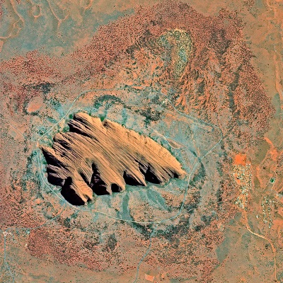
    Uluru (Ayers Rock), Australia, imaged by SPOT 6
    Uluru (Ayers Rock), Australia, imaged by SPOT 6. Copyright: Airbus

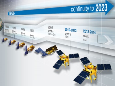
    The SPOT (from French "Satellite pour l'Observation de la Terre") series has been supplying high-resolution, wide-area optical imagery since 1986. Conceived by the French National Centre for Space Studies (CNES), five satellites were launched between 1986 and 2015, and in revealing Earth’s surface in detail they led to new applications in mapping, vegetation monitoring, land use and land cover, and the impacts of natural disasters.

    The latest satellites in the series, SPOT 6 and SPOT 7, are commercial satellites owned by Airbus Defence and Space, and assure data continuity through to 2024.

    All of the SPOT satellites provide imagery in panchromatic and multispectral bands with a swath of 60 km.

    The SPOT series is part of ESA's Third Party Missions Programme, in which ESA has an agreement with Airbus Defence and Space to distribute data products from the mission.

    SPOT Series Objectives

    The goal of the SPOT series is to improve the knowledge and management of Earth by exploring the planet's resources, detecting and forecasting phenomena involving climatology and oceanography, and monitoring human activities and natural phenomena.

    SPOT Series Missions
    SPOT-1
    SPOT 1 was launched on 22 February 1986 and operated succesfully until November 2003, when it was deorbited. The onboard HRV instrument supplied high-resolution, wide-area optical imagery.

    find out more
    SPOT-2
    SPOT 2 was launched on 22 January 1990 and operated successfully until it was deorbited in July 2009. The onboard HRV instrument supplied high-resolution, wide-area optical imagery.

    find out more
    SPOT-3
    SPOT 3 was launched on 26 September 1993 and operated for three years before suffering a stabilisation malfunction in November 1996. The onboard HRV instrument supplied high-resolution, wide-area optical imagery.
    find out more
    SPOT-4
    SPOT 4 launched on 24 March 1998 and operated successfully until it was retired on 29 June 2013. The onboard HRVIR instrument supplied high-resolution, wide-area optical imagery.

    find out more
    SPOT-5
    SPOT 5 was launched on 4 May 2002 and operated successfully until March 2015. The satellite carried the HRG and HRS instruments, which added new stereo pair imaging for 3D terrain modelling.

    find out more
    SPOT-6
    SPOT 6 was launched 9 September 2012 and was later joined by SPOT 7 to form a constellation providing continuity of high-resolution, wide-swath data up to 2024. It carries the NAOMI instrument.

    find out more
    SPOT-7
    SPOT 7 was launched on 30 June 2014 and operated successfully until March 2023. SPOT 7 formed a constellation with SPOT 6 to provide continuity of high-resolution, wide-swath data. It carried the NAOMI instrument.

    find out more


    Tweet
    Share

    People also search for

    DataNewsMissionsEventsTools and toolboxesActivitiesCampaignsLearn & Discover
    European Space Agency
    Terms and conditionsCookie NoticePrivacy NoticeContact UsFAQComplaintsLeave feedback